Western Trips

Showing posts with label 20th Century. Show all posts

Thursday, May 10, 2012

A Western Trip to the Classic 1955 Ford Crown Victoria / New Mexico

ford crown victoria The very first Ford Crown Victoria was built in the 1955 model year. This new designed vehicle had many distinctive features that really set it apart during the mid 1950's. In many ways it was a significant turning point in automobile design. The Ford Crown Victoria added a sport touch to a family vehicle.

The photos in this article were taken at one of the best smaller car museums I have visited. This classic car museum at the far east end of New Mexico, just a few miles from the Texas border has one of the best collections of vintage automobiles and trucks to be found. The museum is at Russell's Truck Stop in Endee New Mexico. This is right off Interstate 40 at Exit 369.

It's also very near an old famous automobile trail called Route 66. If you're vacationing or traveling anywhere in the area, I would highly recommend you stop in. Having a museum like this in such a remote area is a real gem. It's also a very good reason to take a short rest from driving. Time very well spent.

In 1955, the Fairlane models replaced the Ford Crestline's. Six different models were produced under the Fairlane line, the Crown Victoria Skyliner being one of them. Ford took the name Fairlane from Henry Ford's estate near Detroit which he named Fair Lane. The Fairlane's were built as full sized models. The name Crown Victoria is derived from the stainless band that 'Crowns' the roof line. Ford Fairlanes were in production from 1955 to 1971. The Fairlane models were great sellers for the Ford Motor Company.


1955 ford crown victoria
The 1955 Ford was advertised as a car with the feeling of motion built into the basic shape of the car itself. Ford offered in 1955 an entirely redesigned model, both inside and out. The new Ford design provided longer, lower and wider bodies, the lowest being Ford's new Crown Victoria, which was the company's first closed car under five feet high. A very sleek car indeed for the mid 1950's.

Two of the most unique features of the 1955 Crown Victoria were the stainless steel edging all along the roof line. The second feature was very sporty for it's time but didn't sell too well in the sunny southern states and was discontinued. That was an acrylic glass roof section on the forward part of the roof. This model was called the Ford Crown Victoria Skyliner. Due to the strong southern sun it appears that most of the glass roof models sold in Scandinavian countries where a strong sun wasn't an issue.

ford crown victoria skyliner
The 1955 Ford Crown Victoria came in a  2-door 6-seater hardtop coupe which was  part of the Ford Fairlane line.The Crown Victoria differed from the regular Victoria model by having a lower, sleeker roof line. In addition to the steel trim roof line, the car had more stainless steel trim in general.

 You can see the extra steel trim along the back fins and around the spare tire carrier on the rear. Prices have certainly changed with the times. I have seen 1955 Crown Victoria classic cars selling for $35,000. I have also seen asking prices in the range from $60,000 to $70,000. The factory price in 1955 was $2,300. You'll also find a large market today for 1955 Crown Victoria parts such as the chrome molding.

Two additional articles you should find interesting are the Route 66 and Vintage Cars and America's Car Museum.

You'll want to also visit out site AutoMuseumOnline which has a gallery of vintage and classic cars and trucks along with their history.

If your travel plans include a road trip on Interstate 40 in New Mexico which is generally along the old Route 66, there are several fine auto museums and collections along the way. Another one that is a must stop is in Santa Rosa New Mexico.You'll find an amazingly large collection of vintage cars and trucks at the Route 66 Auto Museum located at 2411 Historic Route 66 in Santa Rosa. The Route 66 Auto Museum also sells some of the vintage cars on display. It's quite an impressive museum with a lot of old Route 66 history. It' definitely worth a visit. 


(Article and photos copyright Western Trips)


Sunday, May 6, 2012

Healdsburg California / A Western Road Trip to the Sonoma Wine Country

healdsburg california
Healdsburg California is a delightful Sonoma Wine Country destination with a lot to enjoy. The town is built around a 19th century plaza. The plaza today is a venue for many fun events scheduled throughout the year. Around the plaza can be found unique shops and restaurants with some even with five star status. If you're a fan of B & B's, you'll find some excellent ones in and around Healdsburg. If you're looking for that unique hotel, Healdsburg California hotels offer a wide variety. You'll also find many fine Sonoma vacation rentals.

Don't miss the art galleries. The art galleries include cooperatives to local one artist storefronts. You'll find works of nationally and internationally known artists. June is Jazz Festival time in Healdsburg. The Jazz Festival which began in 1999 offers many free events and tickets are available for their headliner acts. Concerts take place all over Healdsburg with many at  outdoor venues. The festival is a ten day celebration of jazz in the middle of one of the most picturesque wine towns north of San Francisco. Other events include antique fairs and car shows.

History of Healdsburg

The town of Healdsburg California was made possible by a man named Harmon Heald. Heald was originally a businessman from Ohio and in 1857 took hold of a section of land  in Sonoma County called the Rancho Sotoyome where he had been residing for the past seven years. This would have been from the start of California statehood. In 1867, Heald's growing town was incorporated.

The economy was principally farms and orchards. A big plus for Healdsburg was in 1872 when the tracks of the San Francisco and North Pacific Railroad reached the town. Rail service became extensive throughout Sonoma County. The railroad helped the town gain population and in transporting agricultural products to market.

Sites to See in Healdsburg California


healdsburg california wine country
Another good stop in Healdsburg is the Healdsburg Museum and Historical Society. The museum has an excellent display of artifacts regarding Healdsburg and the surrounding Sonoma County area. Featured are collections from the local Pomo and Wappo Indian tribes which include a large collection of decorative and utilitarian baskets.

Also, Native American stone tools and ethnographic research materials from the Southern Pomo and Western Wappo tribes. Both of these tribes are noted as being the world’s most skilled basket makers. In the museum you'll also view vintage weaponry including frontier guns, rifles, a cannon and cannonballs, and other items used both in battle and for hunting. Included are many other artifacts of clothing, classic farm tools and paintings. They include oils, acrylics, watercolors, large framed photographs of historic Healdsburg and Sonoma County. The museum is a excellent showcase for the entire north bay region of California.

Visit the Healdsburg Wineries

healdsburg ca
Healdsburg wineries are located everywhere in and around the town. There are numerous wineries all around Healdsburg in every direction.

Two small wineries not far from Healdsburg which you may be interested in are the Benovia Winery and the Hafner Vineyard. Benovia Winery located in the heart of the Russian River valley harvests grapes from estate vineyards that span more than 71 planted acres in three distinctive locations across the Russian River Valley and Sonoma County. Their winery address is 3339 Hartman Rd. Santa Rosa, CA.

The Hafner Vineyard is a small family winery located in Sonoma's Alexander Valley. They have been making Cabernet Sauvignon and Chardonnay for thirty years only from grapes grown at their winery. Hafner Vineyard reserves two visiting times each month for  visitors. The times are 2 p.m. on the first and third Fridays of every month. Their phone number is 707-433-4606.

Some of the larger wineries within easy driving distance of Healdsburg include the Francis Ford Coppola Winery in Guyserville. Their address is 300 Via Archimedes, Geyserville, CA.

Another is the Rodney Strong Vineyards. They are located just off U.S. Highway 101, three miles south of Healdsburg on Old Redwood Highway. Guided winery tours are available daily at 11 a.m. and 3 p.m. Another is Windsor Vineyards which has a tasting room in Healdsburg at 308 Center Street. The winery is located at 205 Concourse Blvd, Santa Rosa, CA.

The following two articles may give you some additional ideas for your wine country road trip. The Luther Burbank Home and Gardens in Santa Rosa has been a popular side trip for decades. Also the towns of Bodega and Bodega Bay on the Pacific coast is almost a must if you have the time. Bodega and Bodega Bay were the settings for Alfred Hitchcock's classic movie The Birds.

Nearby Sonoma County Trip Ideas

Healdsburg's location in Sonoma County is ideal as a base for your wine country tour. Many half day or full day side trips are an easy drive away. As mentioned above, not only is the city surrounded with wineries in about a ten to fifteen mile radius, but the city is also near to many recreation areas.

One of the most popular is the Russian River which flows directly through Healdsburg and west to the Pacific Ocean. The Russian River is noted for it's canoeing and kayaking. Several canoeing companies offer trips from the town of Guerneville. Kayaks can be rented during the warm months at Johnson's Beach in Guerneville.  A short drive west of Guerneville is the scenic Pacific coastline. All oif these attractions and sites are within an easy drive from Healdsburg.

Healdsburg is located off U.S. Hwy 101 about 65 miles north of the Golden Gate Bridge. Exit Hwy 101 at the central Healdsburg exit.

(Article and photos copyright Western Trips)


View Larger Map

Monday, April 23, 2012

The Donner Pass Train / Southern Pacific's Baldwin Locomotive 4294


The last steam type locomotive ordered by the Southern Pacific Railroad was a very unique designed train. This was a cab forward design 4-8-8-2 configuration. The locomotive was designed to pull very heavy loads primarily over the very high Donner Pass in the Sierra Nevada Mountains.

The Cab Forward Locomotives
 
All of the cab forward engines used by Southern Pacific were oil burning locomotives as opposed to coal. The oil fuel was used to produce steam in the boiler. Interestingly enough, the Sierra Nevada challenged the steam locomotives with some thirty-nine tunnels and almost forty miles of snow sheds.

The cab forward design kept most of the engine's exhaust away from the crew through tunnels. The Southern Pacific Railroad had some 150 miles of track with grades of at least 2.5 percent. On a geographical basis, the Southern Pacific Railroad was thought to have the most difficult routes. This Baldwin locomotive of the AC 12 class was powerful enough to do the job.

Crossing the Sierra Nevada

southern pacific 4294 locomotive
Southern Pacific 4294
The Sierra Nevada's Donner Summit typically has very heavy snowfalls and consequently the railroad has several long snow sheds constructed along very steep mountainsides.

The snow sheds were originally planned back in 1860 by Theodore Judah, a very talented engineer and promoter of the transcontinental railroad. His dream came to reality with the establishing of the Central Pacific Railroad and it's subsequent link as the western segment of America's first transcontinental railroad.

The Sierra Nevada snow sheds can still be seen today to travelers on Interstate 80 driving through the mountains between California and Nevada. Today's route through the Sierra Nevada's is utilized by Amtrak's California Zephyr which operates passenger service between Chicago and Emeryville California, across the Bay from San Francisco.

If  you ever happen to ride the California Zephyr between Reno Nevada and Sacramento, you'll be able to see just how extensive the snow sheds are around the Donner Summit area.

The forward cabin design of these engines kept the train crew away from the smoke and especially so when the locomotive had to run through the tunnels and long snow sheds of the Sierra Nevada's and other western mountains. The 4294 locomotive also was able to bend or turn in the middle. The length of the engine necessitated this so to be able to negotiate curving tracks. The 4294 and all engines of it's class were quite unique. Very different from the standard rear cabin locomotives and much more streamlined.

The only concerns about the new design was from a few of the train crew. The concern was that if they hit a flammable truck at a crossing they would be right on top of the wreck and explosion. Fortunately for everyone involved, in the over forty years these locomotives were in service, an accident like that never occurred. By the same token, having the cab so far forward gave the train crews a great unobstructed view of the track ahead.

The Baldwin 4294

4294 locomotive gauges
World War Two brought along challenges for the American railroad industry. The Southern Pacific Railroad may have been affected the most.

Their routes running to the west coast were vital for supplying the west coast ports with critical war supplies. This meant long and heavy loads and in the case of the Southern Pacific it meant pulling these heavy loads over western mountains.

 As train loads became heavier, the railroads needed more powerful locomotives. One answer to that problem was the development of the AC-12 Class of locomotive of which the 4294 featured here was a part.

This particular locomotive, 4294, was the last of twenty ordered and was built in March of 1944. Baldwin Locomotive was the manufacturer. The engines weight is 657,900 lbs and boiler pressure of 250 psi and it's cylinder size a large 24 x 32 in. The Southern Pacific 4294 stayed in service until 1956.

On Display at the California State Railroad Museum

The Southern Pacific Railroad Baldwin 4294 on display at the California State Railroad Museum in Sacramento California is the only one of it's class that survived. After all of the AC-12's were removed from service, the railroad made the decision to preserve at least one of the models from the class.

The Southern Pacific donated this locomotive to the city of Sacramento who placed it on outdoor display at the Southern Pacific depot in 1958. When Interstate 5 was being built, the locomotive had to be moved and was in storage until 1981. Beginning that year it was moved to the railroad museum. It's fortunate for everyone that this very unique locomotive was kept for historical purposes. It was designed for the tough job of climbing the steep grades of the Sierra Nevada Mountains and it's fitting that it found a home in Sacramento.

california state railroad museum signThe Southern Pacific Baldwin manufactured 4294 is on display at the fabulous California State Railroad Museum in Old Town Sacramento California.

This museum is really a must stop if your vacation or western road trip takes you anywhere near Sacramento. The California State Railroad Museum will amaze you. The number of vintage trains under one roof makes it a one of a kind venue.

Another Western Trips link with photos you'll find interesting is a trip on Amtrak's Coast Starlight.

The California State Railroad Museum is now over forty years old. This museum features 21 lavishly restored locomotives and cars, some dating back to 1862.

There is a full-scale diorama of an 1860s construction site high in the Sierra Nevada as well as a bridge elevated 24 feet above the museum floor. The locomotive collection of the California State Railroad Museum contains 19 steam locomotives dating from 1862 to 1944. As an added railroad adventure for the family, the museum operates an excursion train on weekends, April through September.

(Article and photos copyright Western Trips)

Friday, April 6, 2012

California Trips / A Fun Road Trip to the California Coast

When it comes to California trips, there's a lot to choose from and one of the best things about visiting the San Francisco Bay area are the added tourist destinations within a days drive from the city. The city itself surely has it's share of interesting vacation stops and when your stay in San Francisco allows you to explore more of northern California, a western road trip to the California coast from the Bay Area is a fun addition to your road trip agenda.

san francisco california
San Francisco California
This particular article showcases some beautiful and historic west coast tours within an easy days drive south of the Bay Area and are quite scenic California trips.. Depending on where you start out from, a road trip down to Monterey or Carmel is anywhere from ninety minutes to a few hours one way. This allows a leisurely drive with enough time to enjoy some great sites along the way and, after spending the night, another leisurely drive back to the Bay Area with plenty of time to make stops on your return. There are many fine hotels in Monterey and the surrounding area at at all price ranges.

Two of the most visited west coast destinations on the California coast south of San Francisco are Monterey and Carmel. Both seaside communities are picture perfect and a great place to take pictures as well. In addition to the scenery and excellent restaurants are several very interesting historic sites. This area of California is very historic particularly in regards to the Spanish colonization of what was then referred to as Alta California. In fact, for many years Monterey was the seat of the Spanish California government. A Monterey vacation has plenty to offer.

pebble beach california
Pebble Beach Golf Course
A very good stop to add to you road trip planner is the Spanish mission San Juan Bautista. The mission is located in the town of San Juan Bautista just a few miles off of US Hwy 101 and about 33 miles northeast of Monterey. It's a good stop on your drive down from the Bay Area. In addition to the mission itself are several historic structures including an old hotel and livery stable. The Spanish mission system built by the Franciscans was a key part of Spanish colonization. It's very scenic and directly on the old Spanish Mission Trail. The following link will give you a lot more information on this historic site as well as photos. Mission San Juan Bautista.

Another excellent stop to consider is the Steinbeck Center located in Salinas California, just a short drive east of Monterey. The Steinbeck Center honors the writing and career of John Steinbeck who grew up in Salinas and spent a good deal of time in Monterey. One of Steinbeck's most popular novels of course was The Grapes of Wrath. The following link tells more about the Steinbeck Center with photos. The Steinbeck Center.

Further on down the coast is Carmel-By-The-Sea. Carmel happens to be the site of California's second Spanish mission built, the first being in San Diego. The Carmel Mission was first erected in Monterey in 1770 and then rebuilt in Carmel a short time later under the direction of Father Junipero Serra. This mission as well as the one in San Juan Bautista are still conducting mass. The Carmel Mission is named San Carlos Borromeo de Carmelo. The mission in Carmel is on the National Register of Historic Places and is also a National Historic Landmark. The Carmel Mission serves as a place of worship and also hosts concerts, art exhibits, lectures and many other community events. For more information on the Carmel Mission along with photos see our article San Carlos Borromeo de Carmelo.

carmel california beach
Carmel California Beach
There are many fun things to do in Monterey including a visit to Fisherman's Wharf and, if time permits, a whale watching boat ride. The Pacific Ocean off the Monterey and Carmel coasts is home to one of the richest marine life sanctuaries in the entire world. The sea floor canyons are very deep and this attracts a large variety of marine life and as a result is one of the west coast's best locations for whale watching.

On this same topic, Monterey is home to the world renown Monterey Bay Aquarium. I've visited this museum several times and enjoyed each and every visit. The museum was established in 1984 and is on the site of a former sardine factory on Monterey's Cannery Row. The Monterey Bay Aquarium can easily fill a half day of your visit.

Another fun drive while visiting the Monterey Peninsula is the 17 Mile Drive. The drive goes through Pacific grove and Pebble Beach and as you can imagine a great place for photos. The 17 Mile Drive will take you right past the Pebble Beach Golf Course which has to be one of the most beautiful golf settings in the world. You can begin the 17 Mile Drive at the Pacific Grove gate and exit at the Carmel gate to the south. It's one of the most leisurely and scenic drives you can take.

One stop on your way south from the San Francisco area, a bit out of the way perhaps but well worth it, is Moss Landing. Moss Landing is about 15 miles north of Monterey and is home to the very popular Phil's Fish Market. Great fresh seafood and it's right on the ocean. The most visible land mark that will help you find Moss Landing is the power plant. Near the power plant smoke stacks is Moss Landing Road. If coming from the north make a right hand turn. If from Monterey then turn left. Drive over the bridge and you'll see Phil's on the left hand side. Phil's Fish Market has been featured on the Food Network and is well worth the stop. Weather permitting there is both indoor and outdoor seating.

(Article and photos copyright Western Trips)


View Larger Map

Saturday, March 24, 2012

Big Sur and the California Highway 1 Bridges

Driving California Highway 1 along the Big Sur coastline is certainly one of the most scenic Pacific coast drives you can take. This is million dollar scenery and if you are planning a California vacation you will want to add this to your trip planner if at all possible. The Big Sur coast drive is spectacular and the bridges along Highway 1 are an interesting historical  story themselves. The following Big Sur photos will give you an idea of just how difficult it was to complete this coast highway.

The Concept of a California Route 1

bixby bridge big sur
Bixby Bridge, Big Sur California
The concept of Route 1 Big Sur had it's beginnings in the very early 1900's. According to the Cambria California Historical Society, the idea for a road along the coast in Big Sur came from a Dr.John L.D. Roberts.

Dr. Roberts idea arose during the time he was responding to the SS Los Angeles that had the misfortune of running aground near the area of the Point Sur Lighthouse. It took the doctor hours to reach the scene and this convinced him that a coastal roadway needed to be built all the way south to San Simeon.

Dr. Roberts surveyed the area and estimated that a road would cost about $50,000. The Big Sur CA doctor was known to speculate in real estate and therefore had good reason to want a coastal highway. He well knew the spectacular beauty of the Big Sur coast and of course would directly benefit from a tourist industry that would surely follow. As it turned out, after enlisting help from people in power such as a state senator, plans were eventually approved for the project but on the grounds of building a military highway, not one for the tourist trade.

The Famous Bridges of Big Sur

Coming from the north on Highway 1 out of Monterey or Carmel California, the first bridge entering the Big Sur region you'll cross is the Bixby Bridge. Many feel this is the most scenic of all the Big Sur bridges. It's also considered the world's highest concrete single-span bridge.  The Bixby Bridge is over 260 feet high and over 700 feet in length. The bridge was constructed by the Ward Engineering Co. of San Francisco. It was completed on October 15th 1932 at a cost of  $202,334. It was estimated that about 45,000 sacks of cement were used for it's construction.
bixby bridge in big sur california
Bixby Bridge and Big Sur coastline

The Bixby Bridge was formally dedicated on November 27th of that year. Building this particular bridge was difficult especially at it's base. The foundation had to resist the waves which at certain times reached its base. The framework took two months itself to build. You can see from the photo at right the difficult and dangerous work it took to lay down the bridge foundation. Foundations had to be secured on the walls of steep cliffs.

If you stop at this site for picture taking, one of the first things you'll notice is an unpaved road to the left just before the bridge. Interestingly enough, this was the road you had to take heading south prior to the Bixby Bridge's construction. Driving on this unpaved road that winds high around the canyon takes a vehicle with both high clearance and four wheel drive. At least that's what is recommended for a safe passage. Historians will note that at one time, prior to Big Sur Route One, being designated the coastal road, the passage was then called Route 56, or the Carmel-San Simeon Highway. The highway hugs the coast so closely that during World War Two a nighttime blackout was ordered there to prevent the coast from being spotted by Japanese submarines.


old route through Big Sur
Old road used prior to bridge
Because Big Sur Route 1 crosses many canyons and inlets, there are several bridges in the Big Sur region. Another one of these bridges is the Granite Canyon Bridge. The bridge was built in 1932 and spans 127 feet with a 24 foot width. This bridge like the others is a concrete span bridge. This bridge was built by George J. Ulrich Construction Company of Modesto for a cost of $33,700

The Garrapata Creek Bridge, about thirteen miles south of Carmel, has a 150 foot span about 85 feet above the creek plus one 25 foot approach span on the north and four on the south making the total length 285 feet. It was built by Hanrahan Company of San Francisco at a cost of $35,500 and O. R. Bosso was the resident engineer. The arch on this bridge carries the roadway about 100 feet over the creek. As you can easily see by the topography along the Big Sur coastline, any highway built will necessitate the construction of bridges that will span very high over the creeks it crosses. On the photo below you can see the fog hovering on the mountains which is characteristic of the Big Sur coastline.

big sur garrapata creek bridge
Garrapata Creek Bridge
This area of California's coastline is known for it's mountains virtually touching the sea. Another area similar is north of the San Francisco Bay area on Hwy 1 north of the town of Jenner. While there not these type of bridges constructed there, Hwy 1 is full of switchbacks that hug the edge of the mountains.

The Building of California Route 1

Appropriations for funding construction of Hwy 1 were approved by the state in 1919. Federal funds were appropriated and in 1921 voters approved additional state funds. An interesting side note is that a good deal of the road's construction was done by prisoners from San Quentin State Prison. Prison camps were set up at various points to house the inmate workers. Highway 1 was officially completed in 1937.

Constructed lasted some eighteen years and during the 1930's was helped with funding from the New Deal program. First being called the Carmel-San Simeon Highway, the road was renamed California Highway 1 in 1939. Over the years there have been some realignments with California Highway 1 but the road along the Big Sur coast has remained constant.

You may find the following three articles below related to the area around Big Sur interesting. 

Their links are Carmel By The Sea and a popular city just a few miles north of Carmel, Monterey California and it's harbor. 

Also see the Historic Custom House in Monterey

Even though the highway was completed in 1939, the Big Sur region remained one of the most remote areas in the country. Electricity didn't reach Big Sur until the 1950's and the area had just a few structures and few residents. Eventually, and for good reason, Hwy 1 in Big Sur was named California's first State Scenic Highway in 1965. Even today, Big Sur remains a relatively remote area although that stretch of Highway 1 brings thousands of tourists annually through the region. A great thing for tourists driving through is that there appears to be a good number of turn out areas where one can snap some pretty scenic pictures of the coastline.

granite canyon bridge in big sur ca
Big Sur Granite Canyon Bridge
The photo left is of the Granite Canyon Bridge which was built in 1932. This bridge is a bit north of the large Bixby Bridge eight miles south of Carmel. This is also a concrete arch bridge.

Visit Big Sur California

The Big Sur coast is noted for not having any urban areas. What you have are small groups of stores and or restaurants along with a gas station in a few areas.

 For those wishing to escape the urban life, if for at least a short while, then Big Sur needs to be on your trip planner. Weather is what you would expect for the central California coast. Due mainly to the ocean water, temperatures along the Big Sur coast don't change too much during the year with warm dry summers and cooler wet winters. Daytime temperatures usually high 60's to low 70's and in the 50's at night.

The bridges along Highway 1 through Big Sur CA is what made this scenic road possible in the first place. Hopefully you'll have the opportunity to enjoy this fun road trip and see the amazing string of concrete bridges built back during the days of the 1930's. Great coastal scenery, unique dining establishments, hiking trails, unique camping options and much more await you in fabulous Big Sur CA.

(Article and photos copyright Western Trips)


View Larger Map

Tuesday, March 13, 2012

Route 66 and Tucumcari New Mexico / A Western Trip

tucumcari tonite sign
Tucumcari Tonite Banner along Route 66
When you're driving on today's Interstate 40 approaching Tucumcari New Mexico from either east or west, chances are you'll see the Tucumcari hotel road signs proclaiming "Tucumcari Tonite". That slogan has been seen by New Mexico motorists and vacationers for decades.

Tucumcari Along Route 66

The signs dotted historic Route 66 almost from it's inception. As you may remember, ther was also a Rout 66 song. When traveling west out of Texas, not only does the scenery change but vacationers will find Tucumcari, the first larger town they'll find in New Mexico. Many people consider it the gateway town to New Mexico.

 At it's peak, Tucumcari offered travelers some 2,000 hotel rooms. Today, the number is a fraction of that amount. There is however a Tucumcari motel that has survived over all of those decades and that is the Blue Swallow Motel. Originally called the Blue Swallow Court, the Tucumcari NM hotel was built between 1930-1941 and it's believed to have opened for business in 1941.

The Colorful History of Tucumcari NM

Tucumcari has a long history of being a travel stop and a crossroads of sorts. In fact, the map of Route 66 changed over the years with various rerouting in some states including New Mexico, but as far as Tucumcari was concerned, the road always went through the center of town.

Before the automobile descended upon it, Tucumcari was a railroad town. Tucumcari was founded in 1901 even before Quay County itself was established. The year 1901 was also the time that the Chicago, Rock Island and Pacific Railroad built a construction camp in what is now the western portion of Quay County. The Rock Island camp was originally given the nickname of "Six Shooter Siding" because of it's too numerous gunfights.

Certainly not an inviting name and not a good name for a permanent community, the name of Tucumcari was adopted officially in 1908. This railroad was in competition with the Atchison Topeka & Santa Fe Railroad between Chicago and Los Angeles. The Rock Island route went through Tucumcari and then south to El Paso before heading west to California.

The AT&SF ran more to the north following much of the old Santa Fe Trail in New Mexico. The AT&SF Railroad along with Fred Harvey promoted Santa Fe heavily as a tourist destination. Although the railroad has always been a major part of Tucumcari, the town really gained it's biggest publicity from it's connection to old Route 66.


tucumcari mountain
Tucumcari Mountain
How did Tucumcari Get it's Name?

That's really a good question and there doesn't seem to be unanimous agreement among historians although their are a few credible answers.

What seems to be the best explanation comes from a man named Elliot Canonge, a linguist in Oklahoma. Canonge believes that the term is derived from the Comanche "Tukamukaru". This term means to lie in wait for someone or something to approach. Canonge also learned that Tucumcari Mountain was often used as a lookout. This does sound like a credible explanation.

Another historian has an equally convincing explanation. According to historian Herman Moncus, the name Tucumcari could have come from the Jemez Indians who hunted in the area of present day Tucumcari. Moncus says that he can translate Tucumcari into the Jemez language which means "place of the buffalo hunt". 

Several Explanations for It's Name

Another explanation is less factual although quite colorful. The story that's floated around involves a story about an old Apache chief. The aged chief was very concerned as to who would take his place after he passed away. The answer the chief came up with was to select two candidates among the young men of his tribe and have them fight against each other with knives. The winner of the fight would assume the chief's role after he died. The two warriors were named Tonopah and Tocom. The chief also had a daughter named "Kari". The survivor of this fight would also win the chief's daughter for marriage. The tale goes on to say that Tocom, who Kari really loved, was slain by Tonopah. In her grief, Kari allegedly grabbed the kinfe, killed Tonopah and then killed herself. The distraught chief then killed himself and while dying cried out "Tocom-Kari", "Tocom-Kari". While not verified, the story still survives.

Visiting Tucumcari

route 66 in tucumcari
A stretch of Route 66 through Tucumcari
The modern Tucumcari has quite a lot to offer and a lot of interesting Tucumcari hotels are still to be found. It is home to Mesalands Community College that has, among others, excellent programs in paleontology and operates the Mesalands Dinosaur Museum. The museum has been open since 2000 and gets visitors from all fifty states. In case you wonder why a dinosaur museum is in Tucumcari, the city and college is located in a unique location which is advantageous for fossil exploration. The mesalands of northeastern New Mexico are filled with fossils. Everything from dinosaur footprints to mammoth tusks. The museum is filled with many great exhibits and a lot of educational material. Mesalands Community College is also noted for it's North American Wind Research and Training Center and offers both certificate and degree programs.

Tucumcari's business community points out their strategic location to major markets in Colorado, New Mexico and Texas.

Tucumcari also boasts Ute Lake Ranch which is a 25,000 acre master planned community on the north and south shores of Ute Lake. There is also a Ute Lake State Park. The lake area, a Canadian River reservoir, is home to ducks, quail, doves and pheasant. Deer and antelope can be found roaming about the surrounding plains and mesas. The park is located three miles west of Logan NM via N.M. 540.

Tucumcari as a Movie Set

When you drive to Tucumcari and view the scenery, you just have to know that the area was used as locations for various movie and television productions. For those who remember the old television western series "Rawhide", many of the scenes were shot around Tucumcari between 1959 and 1966. There was a movie produced in 1971, "Two-Lane Blacktop" which has a scene showing Tucumcari Mountain in the background. Another movie credit that Tucumcari can boast about involves the Sergio Leone 1965 production of "For a Few Dollars More". That movie starred both Clint Eastwood and Lee Van Cleef.

Another article on Western trips you'll find interesting is the story of historic Puerto de Luna New Mexico.

Tucumcari is a very interesting and scenic place to visit with a lot of old Route 66 nostalgia. When you're on that western road trip on Interstate 40 in eastern New Mexico you just might want to make it Tucumcari Tonite.

(Article and photos copyright Western Trips)

Thursday, February 9, 2012

John Steinbeck Center and Monterey California / A Western Trip

 
monterey california harbor
Harbor at Monterey California
The famous American writer, John Ernst Steinbeck,Jr., born in Salinas California in 1902, might best be remembered by his Pulitzer Prize winning novel, The Grapes of Wrath, which was published in 1939 near the end of the Great Depression.

John Steinbeck's  Monterey California

While being the author of twenty-seven books, John Steinbeck was also a very big part of Monterey California.

Monterey County California has many historic sites connected with Steinbeck including it's Cannery Row, a big attraction for tourists. In fact, anyone who has been on a road trip to Monterey knows how picturesque this coastal city is. Many tourists enjoy the Monterey hotels on Cannery Row which are directly on the water.

Monterey is located just about 100 miles south of San Francisco and because of this close proximity to the City By the Bay, it's quite a favorite side trip and remains a top item of things to do in San Francisco. Lodging and restaurants in Monterey can fit any travel budget and, if you haven't traveled there, you really need to add it to your California vacation planner.

In addition to visiting Monterey, you'll want to set time aside to visit the National Steinbeck Center in Salinas California which is a great way to learn more about this unique writer. The John Steinbeck biography encompasses both Salinas CA and the Monterey area. The Steinbeck Center lets you view the life of Steinbeck through interactive, multi-sensory exhibits for all ages. There are rare artifacts and seven themed theaters showcasing East of Eden, Cannery Row, Of Mice and Men, The Grapes of Wrath and much more. It's the best place in the world to gain insight into John Steinbeck's life and writings It's a fun and educational experience and definitely worth your time.

John Steinebeck

cannery row in monterey
Cannery Row in Monterey California
The John Steinbeck biography includes being raised in Salinas California just a short drive east of Monterey and a graduation from Salinas High School in 1919. He went on to attend Stanford University in Palo Alto, just south of San Francisco. Even though Steinbeck attended Stanford for five years, he left without receiving his degree. From there he decided to travel to New York City and work at odd jobs while trying to start a writing career.

The New York writing career venture wasn't working out and Steinbeck then decided it was time to head back across the continent to California. He found a job as a caretaker at a home at Lake Tahoe California and worked there from 1926-28.

Steinbeck married for the first time in 1930, right at the start of the Great Depression. His bride was named Carol Henning who he had met while working at Lake Tahoe. Steinbeck and his new wife for some time in a cottage in Pacific Grove, directly next to Monterey and near the point of the Monterey Peninsula. The cottage was owned by his father who worked for the Monterey County government. During this period he spent time caring for his ill mother who resided in Salinas. Steinbeck's mother passed away in 1934 and, as events would have it, his father passed away about a year later in 1935.

Steinbeck was also focused on his writing projects while living in the rent free cottage in Pacific Grove. The elder Steinbecks also bankrolled his writing efforts with loans starting in 1928 and supplied him with paper so that he could subsist and totally concentrate on his writing.

Steinbeck's Writings

john steinbeck poster
Banner on Cannery Row
John Steinbeck first published the novel, "Cup of Gold" in 1929 and three shorter books between then and 1934. Steinbeck's  novel, "Tortilla Flat", was set in Monterey and published in 1935 and was his first critical success.

In 1939, he published which may have been the most noted Steinbeck novel, "The Grapes of Wrath", which wrote about a family, after losing their Oklahoma farm, journeys to California, where they face hardship and injustice as migrant workers. The novel hit a chord with many in the American public who, after witnessing a financial depression along with the "dust bowl" years in the plains states, journeyed to California over historic Route 66 to build a new life and search for opportunity. For many Oklahomans, the Grapes of Wrath exemplified life in the 1930's.

Steinbeck then published "The Log From The Sea of Cortez". This work was the result of a six week trip around the Gulf of California on a borrowed sardine boat with a good friend, Ed Ricketts, a marine biologist. Steinbeck accompanied Ricketts on this voyage to obtain marine biological specimens and, as a result, this publication is believed by most Steinbeck historians to be his most important work of non-fiction. Unfortunately for the couple, the Steinbecks were divorced not long after his return from the trip to Baja California. Most reports were that the marriage had been in trouble for some time and perhaps the voyage with Ricketts hurried things along.
Steinbeck the War Correspondent


national steinbeck center
National Steinbeck Center
With the start of World War Two, John Steinbeck did what several other writers and journalists did, he became a war correspondent.

Actually, Steinbeck became a correspondent about a year before another popular writer, Ernest Hemingway, decided to do the same. This was a bit surprising since Hemingway had already been involved with the Spanish Civil War in the late 1930's.

Steinbeck was employed by the New York Herald Tribune and the London Daily Express. He was based out of London but went many places including the war zone in North Africa. He also was present during the U.S. landing at Salerno Sicily. Steinbeck went back home to California in 1944 after being injured in a munitions explosion.

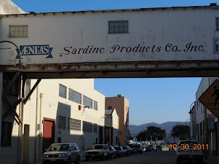
The Steinbeck novel, "Cannery Row", published in 1945,  takes place on a street lined with sardine factories which was exactly what Monterey's Cannery Row was at that time. In fact, the street had been named Ocean View Avenue and renamed Cannery Row in honor of the Steinbeck novel. The Cannery Row book, similar to The Grapes of Wrath, was set during the Great Depression. Today, Cannery Row is lined with shops, hotels and restaurants.

Another short story on our Western Trips site regards Jack London and California's Jack London State Park near Sonoma California, just north of San Francisco. A visit to the Jack London Park is a good and quite interesting addition to your Sonoma Wine Country tour.

Visit the John Steinbeck Center in Salinas Califronia

There is much more to learn about the amazing literary life of John Steinbeck. The Steinbeck Center in Salinas California is a great place to start. The National Steinbeck Center is located at One Main Street, in the historic Oldtown Salinas, the birthplace of Nobel Prize-winning author John Steinbeck.

You may also want to stop by at John Steinbeck's childhood home which is located at 132 Central Avenue in Salinas. Being located only about 17 miles east of Monterey, about 60 miles south of San Jose and 100 miles south of San Francisco, a visit to the National Steinbeck Center can be combined with visits to other nearby historic sites such as the Carmel Mission and the Mission San Juan Bautista.

A visit to the National Steinbeck Center makes the perfect short weekend road trip or a good addition to your California vacation planner.

(Article and photos copyright Western Trips)


View Larger Map

Wednesday, February 8, 2012

Salado Texas

salado texas
Salado Texas Shopping
Located directly Interstate 35 in central Texas, Salado may very well be the best little art town in the entire state. Salado Texas is located north of Austin and south of Waco and Interstate 35 is probably the heaviest traveled highway in the state. Salado's Main Street and vicinity is filled by over sixty unique shops and artists galleries. Inn fact, Salado has one of the most unique art galleries in Texas. If you're into antiques, fine art, pottery and southwest collectibles and more, then Salado Texas should be on your Texas vacation planner. Salado is a blend of history and Texas folk art and is one of the best Texas day trips you might make. If you're traveling along Interstate 35 between San Antonio and Dallas it's definitely a great side trip.

Together with the very unique shopping in Salado are several excellent hotels and bed and breakfast inns. Located right in the middle of Texas Wildflower country, you can enjoy carriage rides and leisurely walks and if there's a golfer in your group, Mill Creek Golf Club offers a championship course. Mill Creek features three nine-hole courses designed by world renowed architect Robert Trent Jones Jr.  The casual atmosphere of the facility, the beauty of the environment and the classic test of the golf course combine to provide one of the finest golf experiences in Texas at very affordable rates. I've played this course several times and it's a good one. Mill Creek also offers condo rentals which are very near the golf courses.

Main Street, Salado Texas
Salado Texas has been around a long time. It's right on the way south from Dallas towards the Texas Hill Country. Salado was first incorporated in 1867 for the sole purpose of building a bridge across the Salado Creek which runs though the center of town. You'll find many historic sites around Salado. The Stagecoach Inn is the oldest continuously run hotel in the state of Texas.

The George Washington Baines House in Salado is on the National Register of Historic Places. Baines was the great grandfather of former U.S. President Lyndon Baines Johnson. George Baines was a minister and founded several Baptist churches and newspapers in Texas. Baines was the third president of Baylor University and reportedly had baptized Sam Houston. George Washington Baines was certainly an active figure in early Texas.

White settlers first appeared in the area around 1834. In that year, a settlement where Salado is today, was right on the western fringes of the Texas frontier. In fact, settlers in that specific area were under Indian attack often. Nearby was Parker's Fort which was the site of a brutal Comanche attack killing and kidnapping the entire Parker family. This was the attack that years later produced the half breed Comanche leader and warrior Quanah Parker. Parker was also the last Comanche leader to surrender in the 1870's ending the decades long Comanche War. As years went by, the frontier line in Texas would have kept expanding westward as more people came and the army forts were established accordingly. Texas was a very volatile region in the mid 1800's.

salado texas shops
Store on Salado's Main Street
As Salado history goes, the town was right in the line of progress. The old Chisholm Trail ran right past the town going from south Texas past Salado and eventually to the rail heads in Kansas such as Abilene. At one time in the mid 1800's, the Overland Stage and Pony Express stop ran right through the town. Several popular figures overnighted in Salado Texas including Robert E. Lee, Sam Houston and General George Armstrong Custer. There are also tales that the legendary train and stagecoach robberl Sam Bass and the James brothers may have passed through town as well. When you visit Salado you'll see The Stagecoach Inn which was involved with the old stage line. The hotel was founded in 1861 as the Shady Villa. The Van Bibber family bought it in 1941, beginning the heritage of Salado's Stagecoach Inn and it's famous dining room. The dining room has an old-fashioned atmosphere with many wood details including homey shelves and cupboards. The Stagecoach Inn itself is a historic site where the wheels of progress, the stagecoach, made it's regular stop.

There are more than a dozen historic homes found in Salado. Today, many have been converted into restaurants, shops or B and B"s.The Baines House mentioned above is now a Salado B & B. The main house was the home of George Washington Baines. Another Salado B & B that I'm acquainted with is the Rose Mansion. The main house was constructed in 1870 by Major A.J. Rose and has four bedrooms. Three of them fireplaces. You'll also see Rose family memorabilia and a  great collection of antiques. This B and B was featured several times in Southern Living Magazine between 1996 and 1999.

salado texas art gallery
The historic Barton House
Another stop to make while touring Salado is The Central Texas Area Museum. This museum was established by a group of interested citizens of the Central Texas area and received its area charter from the State of Texas in 1958. The museum opened a year later. The Museum is housed at present in a beautiful old rock building more than 100 years old just a few hundred yards from the picturesque clear spring-fed Salado Creek. A major purpose of the museum is to tell the history and development of Central Texas. You'll be able to enjoy an excellent collection of Texas pioneer artifacts as well as a lot of research materials.


Salado is the perfect stop for a food or shopping break while traveling on Interstate 35. The Salado Historical Society also offers a driving tour of the village available on both CD and Cassette format. Their website is www.saladohistoricalsociety.org. Other nearby fun vacation or trip stoips are the Texas Ranger Hall of Fame Museum in Waco Texas and the famous and historic Driskill Hotel in Austin.

(Photos from author's private collection)

Sunday, February 5, 2012

Big Sur California / A Western Road Trip Like No Other

big sur california
Big Sur coastline
If you have an opportunity to take a California vacation and your plans include a road trip in the central part of the state, you will be very well rewarded including a drive on California Hwy 1 along the simply magnificent Big Sur coastline. I have driven this route several time over the years and I will say there is no other quite like it. The pictures on this page will give you a good glimpse of just how beautiful this stretch of California coastline is.

A Very Popular California Destination


If your road trip through the California Big Sur turns out to be more than a day trip and you decide to stay awhile an enjoy the area, there are an abundance of Big Sur campgrounds. Big Sur camping has long been a favorite for many tourists and northern California locals. There are also some very unique hotels in Big Sur. One favorite is Deetjens Big Sur Inn.This Big Sur Inn happens to be on the national Register of Historic Places and is currently operated by the Deetjens Big Sur Inn Preservation Foundation. This Big Sur Inn was actually built over a span of three decades from the 1930's to the 60's. Deetjen's Big Sur Inn offers both rooms and cottages.

big sur coastline
Rugged cliffs of Big Sur
Additional great lodging in Big Sur California is the Big Sur River Inn. The Big Sur River Inn is directly on Hwy 1 and nestled alongside the scenic Big Sur River. The Big Sur River Inn has been in operation since 1934 and among other things offers the visitor riverside dining. Like so many other tourist areas of California, the land which today's Big Sur River Inn is situated on dates from 1888 when Jay Pheneger acquired a 160 acre parcel from the U.S.l government. Pheneger gave his name to the creek that bounds the River Inn to the south. Barbara and Michael Pfeiffer, who had already homesteaded and were farming near Pfeiffer Beach later purchased the Pheneger property. A significant event in the area of Big Sur certainly was the eventual paving of the section from Carmel California on southward through Big Sur. The inn has been operated, added to and grown ever since the 1934 opening. It is still operated by both members of the Pfeifer family along with family friends.

river inn at big sur
Big Sur River Inn
For the campers out there, Big Sur campgrounds have plenty to offer. Big Sur camping presents a lot of options. You can enjoy the state parks in Big Sur or try the privately owned campgrounds. The is stream side camping as well as ocean side camping on the high bluffs. Bluff camping is situated on the southern end of Big Sur. Both tent camping and RV camping is available. One popular camping spot is Big Sur Campground and Cabins. The emphasis is placed on family camping and lodging. Tent and RV camping on the forest floor is featured while you can enjoy an inner tube on the cool river. Several styles of cabins, from rustic tent cabins to fully equipped cabins with kitchens and fireplaces are also featured.As you can see, lodging and camping choices in Big Sur California are quite varied. Also, there's something to fit all travel budgets.

People sometimes wonder what the boundaries are for the official Big Sur California historic region. There are actually a few definitions. First of all, there really are no "official" boundaries. One includes ninety miles of coastline from the Carmel River south to the San Carpoforo Creek. This definition extends Big Sur to about twenty miles inland. Some other sources extend the area to only about twelve miles inland. Other people have considered the Big Sur California region to be roughly between Carmel and San Simeon along Hwy 1. One of the reasons that Big Sur makes a fine weekend road trip is that the northern boundary of the area is only about 120 miles south of San Francisco. In fact, there are so many historic and fun stops along the route from San Francisco to Big Sur that a visit there can easily be made into a week long California vacation. Two excellent combination trips along with Big Sur California are the Carmel Mission in Carmel-By-The-Sea and the Mission San Juan Bautista. Both are between San Francisco and Big Sur and you'll pass both of them on your drive.

The History of Big Sur California

big sur road
Hwy 1 along Big Sur
Like much of California, the first Europeans to lay their eyes on Big Sur were the Spanish mariners including Juan Cabrillo. Cabrillo sailed by in 1542 (two years after Coronado's expedition into New Mexico) but sailed past without landing his ships. At the time, the Big Sur area in general were inhabited by three different Native American tribes. The first European to actually land in the area a travel inland was Gaspar de Portola. Portola landed in the southern region of the area and traveled inland from there to not encounter the sheer cliffs of Big Sur. In 1770, Portola landed in Monterey Bay to the north and worked to establish a mission there with the aid of Father Junipero Serra who established the first California mission in 1769 in San Diego. As most people know, the Spanish missions were established in California for really two reasons. One was to attempt to educate and convert the native population to Christianity. The other was to help solidify Spanish control over the entire Alta California area. In a way, the Spanish military worked closely with the Franciscan friars operating the various missions. A tragic byproduct of European exploration into these land that were once the exclusive domains of the Native Americans was that European diseases were introduced. Just as had been the case in the American western frontier one hundred years later, the Native Americans picked up diseases of which their immune systems couldn't handle and many of the died from this.

big sur river
When Mexico took over Alta California after the 1820's Mexican Revolt, the lands of the Big Sur were granted to certain Mexican citizens for Ranchos. Mexican governor Jose Figueroa gave almost 9,000 acres of land to Juan Bautista Alvarado for this purpose. Alvarado eventually gave this Big Sur acreage to his uncle by marriage, a Captain John Cooper in exchange for Rancho Bolsa del Potrero. A good historic site to see during your Big Sur vacation is the Cooper Cabin, built in 1861, which is on the Cooper Ranch and is said to be the oldest surviving structure at Big Sur. The Cooper Cabin, also called the Pioneer Cabin, is at the Andrew Molera State Park.

Weather at Big Sur

Weather in Big Sur can vary greatly. In fact, it's almost impossible to give it any generalization. For one thing, weather can vary significantly between two locations only a mile apart. About the only thing you can on the National Weather Service regarding Big Sur is the high and low temperature forecasts. Many people very familiar with the area contend that you'd need dozens of forecasters at various locations to give a true forecast. What in some other areas of the country might be a rainstorm that starts and stops and then people continue with their plans, in Big Sur a rainstorm has the chance of changing your plans for weeks or more. One truism about Big Sur is that rainstorms can and have washed out roads, such as Hwy 1, and it's not too uncommon for the rain to cause slides which also can close the highway. Winter rainstorms at Big Sur can be problematic.

big sur lighthouse
Point Sur Lighthouse location
If you absolutely had to describe weather in Big Sur, you would say that it has a relatively mild climate year-round. Summer and fall are typically sunny and dry. Winter and spring bring on the rainy season. Temperatures on the coast stay fairly constant throughout the year, ranging from the 50s at night to the 70s by day from June through October. From November to May you are looking at the 40s to 60s. Like most California locales, the further inland you go the more temperatures vary. In any event, when the sun goes down at Big Sur temperatures can be quite cool in any season so a good jacket is always something good to bring along.

It should be mentioned that in addition to being one of the world's most scenic drives and best photo opportunity site in North America, Big Sur is also an excellent place for birding. Birdwatching at Big Sur is a popular activity. Andrew Molera State Park offers a wealth of avian life. The park is some 5,000 acres in size and includes the Big Sur River mouth. It's said that the Molera State Park hosts a list of about 379 species. Surprisingly, people, especially locals, were well aware of the birding potential in Big Sur for many years.l decades. The problem mostly was that the area was not readily accessible until it became a state park in 1972. Still, not as many people as you might think took advantage of the birding opportunities until 1992. At that point a non-profit conservation organization, Ventana Wilderness Society, established a research and education center and bird observatory, Big Sur Ornithology Lab, in the Andrew Molera State Park. This research center has been operating ever since. The establishing of the bird observatory and research center increased the awareness of just how popular Big Sur is as a world renown birding site.

Adding a Big Sur California road trip to your California vacation planner is well worth it. It is truly one of the most unique and scenic automobile road trips in the U.S. and adjacent to many other historic sites in the state.


(Photos from author's private collection).


Thursday, January 5, 2012

Lyndon B. Johnson National Historical Park / Johnson City Texas


The lands and structures that comprise the Lyndon B. Johnson National Historical Park were donated by the Johnson family beginning with the LBJ Boyhood Home and Reconstructed Birthplace in 1969. The Texas Hill Country is a special place in Texas. The natural environment and cultural heritage of the Texas Hill Country is preserved and maintained thanks to a regional network of private and public stewardship. Lyndon B. Johnson National Historical Park is very involved in this stewardship. 

lbj national park signThe LBJ Historical Park is a showcase of the Texas Hill Country's unique place in Texas history and it's connection to some of the programs of the Johnson Administration. The Lyndon B. Johnson National Historical Park includes the old LBJ Ranch located just west of Johnson City Texas. The park tells the  life story of our 36th President. The story begins with LBJ's ancestors, continues through the time that the LBJ Ranch served as the Western Whitehouse during his presidency and ends with his final resting place on his former ranch. The LBJ Ranch, Johnson City Texas and a structure in Stonewall Texas are all part of the LBJ Hill Country park. In addition to the national Park in the Texas Hill Country there is the Lyndon Baines Johnson Library and Museum in Austin Texas at 2313 Red River Street. This is another stop you may want to add to your Texas vacation itinerary.

An interesting permanent exhibit added to the LBJ National Historical Park in 2010 was a thirteen seat Lockheed JetStar. This same aircraft flew in and out of Lyndon Johnson's ranch when he was vice president and president in the 1960s.The acquisition of this plane after so many years is an interesting story. The National Park Service acquired the 50-year-old Lockheed JetStar from the Pentagon's "bone yard". The Bone Yard houses over 4,400 old planes in the dry, desert air of Tucson, Arizona. The NPS paid $261,000 to relocate the plane to Texas, to provide shelter and to restore the exterior of the VC-140 Lockheed aircraft with a new paint job that replicates the outside of Air Force One. When this aircraft was used during the Johnson administration it was nicknamed Air Force One-Half. The President generally traveled on Air Force One which was a Boeing 707. This large airliner couldn't land on the 6,300 foot asphalt airstrip on the ranch so there was a fleet of the smaller Lockheeds available to him. The Jetstar however could land and taxi to within 200 yards of LBJ's  Western White House along the Pedernales River.

lyndon johnson home
The images to the right are of the front and back of the boyhood home of Lyndon Johnson located in the town of Johnson City Texas. This is also a part of the LBJ National Historical Park. Lyndon Johnson spent most of ten years living in this home. In 1908 Johnson was born west of this location in a small farm house located in Stonewall Texas only a few miles west of the ranch towards Fredericksburg. A reconstruction of that house is located in the western unit of the National Park.

Today, the visitor to this home site in Johnson City will see a very neatly landscaped front yard. In reality however, when LBJ lived in this home the surroundings were a bit different. In Johnson's boyhood days, this yard included almost everything needed to sustain a family. This included an orchard, vegetable garden, woodpile, windmill, barn, smokehouse and hog wire fences that kept in chickens and livestock.
lbj home
This home was erected in 1901 by a man named W.C. Russell who was sheriff in Blanco County Texas. The style is folk Victorian and was purchased by the president's father Samuel Ealy Johnson Jr.for $2,925. The home included just under two acres.

The house had electricity installed circa 1930 which was quite an undertaking in this particular part of Texas. Most of rural Texas in the 1930s was still in the dark. Electric lines hadn't been built in the rugged Texas Hill Country. Lyndon Johnson made a campaign pledge early on that once he had the political power to bring change, he would work to bring electricity to the region. Some electric co-op customers and Hill Country residents still talk about the time wheng life in this region meant no electricity. The electrification of the area has long been noted as the key to it's past growth. When you visit the LBJ National Park you will see documentation and artifacts regarding Johnson's work to make electricity a reality for Texas Hill Country residents. Some of this is included in the exhibit of home movies of the era narrated by Lady Bird Johnson.

blanco county texas courthouse
Blanco County Courthouse
Another interesting fact is that, while many assume the name of the town Johnson City in Blanco county came from LBJ, in reality the town got it's name from James Polk Johnson who was a relative of LBJ's grandfather. Another interesting fact about LBJ's boyhood was that his mother, Rebekah Baines Johnson was a schoolteacher. In fact, she was one of the very few college educated women in the area. Her emphasis on education would have an influence on all of her children resulting in all five of the Johnson siblings attending college. Johnson attended a one room school house named Junction School and is only a short distance from this house.

lbj boyhood home The National Park Service acquired the land where the school house is and it's now part of the Ranch unit of the Lyndon B. Johnson National Historical Park.

The fact that the Lyndon B. Johnson National Historical Park is located in the beautiful Texas Hill Country helps makes it a fun place to visit. The Texas Hill Country features many great bed and breakfast inns and is one of Texas' largest tourist areas. The most direct route to Johnson City and the Lyndon Johnson National Historical Park is to drive west from Interstate-35 on Texas Hwy .You can pick up Hwy 290 just a few miles south of downtown Austin. Johnson City is about 50 miles west of Austin. Nearby are many historic Hill Country towns such as Fredericksburg, Wimberley, Boerne, New Braunfels, Gruene and San Marcos. Fredericksburg Texas itself was the boyhood home of Admiral Chester Nimitz and hosts the Nimitz Museum of the Pacific War, an excellent museum which has world acclaim. The Hill Country is also adjacent to both San Antonio and the state capital of Austin, two cities with lots of history and historic sites. Excellent hotels and B & B's can be found in all of these locations. Another very interesting stop in San Antonio is the Guenther House which is also the historic site of the Pioneer Flour Company, started by a German immigrant in the 1850's. The Guenther House is also one of San Antonio's most popular restaurants.


View Larger Map