

The Concept of a California Route 1
 |
| Bixby Bridge, Big Sur California |
Dr. Roberts idea arose during the time he was responding to the SS Los Angeles that had the misfortune of running aground near the area of the Point Sur Lighthouse. It took the doctor hours to reach the scene and this convinced him that a coastal roadway needed to be built all the way south to San Simeon.
Dr. Roberts surveyed the area and estimated that a road would cost about $50,000. The Big Sur CA doctor was known to speculate in real estate and therefore had good reason to want a coastal highway. He well knew the spectacular beauty of the Big Sur coast and of course would directly benefit from a tourist industry that would surely follow. As it turned out, after enlisting help from people in power such as a state senator, plans were eventually approved for the project but on the grounds of building a military highway, not one for the tourist trade.
The Famous Bridges of Big Sur
Coming from the north on Highway 1 out of Monterey or Carmel California, the first bridge entering the Big Sur region you'll cross is the Bixby Bridge. Many feel this is the most scenic of all the Big Sur bridges. It's also considered the world's highest concrete single-span bridge. The Bixby Bridge is over 260 feet high and over 700 feet in length. The bridge was constructed by the Ward Engineering Co. of San Francisco. It was completed on October 15th 1932 at a cost of $202,334. It was estimated that about 45,000 sacks of cement were used for it's construction.
 |
| Bixby Bridge and Big Sur coastline |
The Bixby Bridge was formally dedicated on November 27th of that year. Building this particular bridge was difficult especially at it's base. The foundation had to resist the waves which at certain times reached its base. The framework took two months itself to build. You can see from the photo at right the difficult and dangerous work it took to lay down the bridge foundation. Foundations had to be secured on the walls of steep cliffs.
If you stop at this site for picture taking, one of the first things you'll notice is an unpaved road to the left just before the bridge. Interestingly enough, this was the road you had to take heading south prior to the Bixby Bridge's construction. Driving on this unpaved road that winds high around the canyon takes a vehicle with both high clearance and four wheel drive. At least that's what is recommended for a safe passage. Historians will note that at one time, prior to Big Sur Route One, being designated the coastal road, the passage was then called Route 56, or the Carmel-San Simeon Highway. The highway hugs the coast so closely that during World War Two a nighttime blackout was ordered there to prevent the coast from being spotted by Japanese submarines.
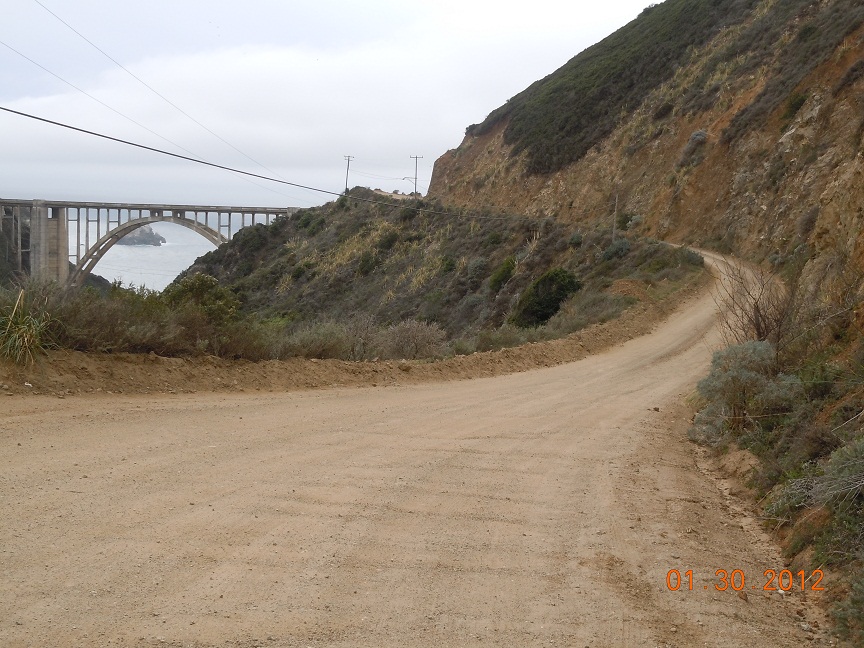 |
| Old road used prior to bridge |
The Garrapata Creek Bridge, about thirteen miles south of Carmel, has a 150 foot span about 85 feet above the creek plus one 25 foot approach span on the north and four on the south making the total length 285 feet. It was built by Hanrahan Company of San Francisco at a cost of $35,500 and O. R. Bosso was the resident engineer. The arch on this bridge carries the roadway about 100 feet over the creek. As you can easily see by the topography along the Big Sur coastline, any highway built will necessitate the construction of bridges that will span very high over the creeks it crosses. On the photo below you can see the fog hovering on the mountains which is characteristic of the Big Sur coastline.
 |
| Garrapata Creek Bridge |
The Building of California Route 1
Appropriations for funding construction of Hwy 1 were approved by the state in 1919. Federal funds were appropriated and in 1921 voters approved additional state funds. An interesting side note is that a good deal of the road's construction was done by prisoners from San Quentin State Prison. Prison camps were set up at various points to house the inmate workers. Highway 1 was officially completed in 1937.
Constructed lasted some eighteen years and during the 1930's was helped with funding from the New Deal program. First being called the Carmel-San Simeon Highway, the road was renamed California Highway 1 in 1939. Over the years there have been some realignments with California Highway 1 but the road along the Big Sur coast has remained constant.
You may find the following three articles below related to the area around Big Sur interesting.
Their links are Carmel By The Sea and a popular city just a few miles north of Carmel, Monterey California and it's harbor.
Also see the Historic Custom House in Monterey
Even though the highway was completed in 1939, the Big Sur region remained one of the most remote areas in the country. Electricity didn't reach Big Sur until the 1950's and the area had just a few structures and few residents. Eventually, and for good reason, Hwy 1 in Big Sur was named California's first State Scenic Highway in 1965. Even today, Big Sur remains a relatively remote area although that stretch of Highway 1 brings thousands of tourists annually through the region. A great thing for tourists driving through is that there appears to be a good number of turn out areas where one can snap some pretty scenic pictures of the coastline.
 |
| Big Sur Granite Canyon Bridge |
Visit Big Sur California
The Big Sur coast is noted for not having any urban areas. What you have are small groups of stores and or restaurants along with a gas station in a few areas.
For those wishing to escape the urban life, if for at least a short while, then Big Sur needs to be on your trip planner. Weather is what you would expect for the central California coast. Due mainly to the ocean water, temperatures along the Big Sur coast don't change too much during the year with warm dry summers and cooler wet winters. Daytime temperatures usually high 60's to low 70's and in the 50's at night.
The bridges along Highway 1 through Big Sur CA is what made this scenic road possible in the first place. Hopefully you'll have the opportunity to enjoy this fun road trip and see the amazing string of concrete bridges built back during the days of the 1930's. Great coastal scenery, unique dining establishments, hiking trails, unique camping options and much more await you in fabulous Big Sur CA.
(Article and photos copyright Western Trips)
View Larger Map