Western Trips

Tuesday, February 22, 2011

Fort Ross/ Northern California


Fort Ross is located north of the San Francisco Bay area on the Pacific Coast Highway on the Sonoma coast. It is approximately 94 miles north of San Francisco and about 12 miles north of the coastal town of Jenner.


Fort Ross was built by the Russians and represents their southernmost expansion on the North American continent. An interesting side note is that when you consider the European countries that explored North America, The French, English and Spaniards traveled west over the Atlantic whereas the Russians went east. All of the world's powers seemed to meet on the North American continent.

Historic Fort Ross

The explorations by the Russians were essentially for trading purposes rather than to colonize. They established the Russian American Company, somewhat on the same lines as the Hudson Bay Company. The main interest was the fur trade such as beaver and otter. Fort Ross itself was established primarily as an agricultural settlement to supply provisions to the surrounding traders. At the time of settlement the Spanish influence in California extended north to San Francisco. The Mexicans went a bit further north up to and around the town of Sonoma. All of this came to an end in the mid 1840's when the United States expanded into California as a result of the Mexican American War.

Fort Ross, circa 1828
Some interesting facts about Fort Ross and the Russian American Fur Company operators had to do with their relations with the Native Americans in the area.

The Russians and the Spaniards in California

The Russians seemed to have forged a good working relationship with the local Indians and trading between the two took place regularly. This of course was much different than the Spaniards to the south who set up a mission system primarily to convert the Indians to Christianity.

The reason for these differences were because, as mentioned above, the Russians never had any serious intentions of trying to colonize the northwest. The Spaniards of course did want to colonize and the Americans who came into Alta California after the Spaniards and Mexicans did as well. The Russian outposts along the northern coast of California extended as far south as today's Bodega Bay and they were there for fur trading purposes.

Regardless of the fact that the Russians never tried to colonize, both the Spaniards and Mexicans after them were concerned about the Russian presence to the north. Most historians seem to believe that this was the reason that the Sonoma Mission and barracks were erected by the Mexicans after Spanish rule ended. The Sonoma Mission was the last mission built and the furthest north.

Visit Historic and Scenic Fort Ross

There are several reasons why Fort Ross CA makes an excellent side trip. The fort has been designated a state park and there is much to explore. Lots of history is explained when you enter the fort compound. It's also very convenient in as much as it's proximity to the Sonoma County wine country and the drive there is spectacular along the Pacific Coast Highway going north from the town of Jenner. It's one of those drives where you'll take many pictures. Fort Ross CA is situated right on the coast with magnificent ocean views.

See our Western Trips articles n the links below...

 Russian River Kayaking

Coastal Hiking at Bodega Bay


These websites will give you a lot of additional information on the area:


www.militarymuseum.org/FtRoss.html


www.googlemaps.com


Here are also some very good restaurants in the towns of Guerneville, Occidental and Bodega Bay south of Fort Ross:

Lucas Wharf- Bodega Bay

The Tides- Bodega Bay


Union Hotel- Occidental


Applewood Inn & Restaurant- Guerneville

Monday, February 21, 2011

Montana Mining / Virginia City

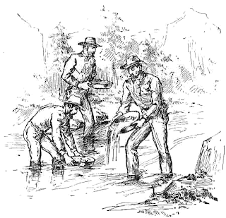
miners gold panning

If you want to add a stop at a real Montana gold mining town during your next Montana vacation, Virginia City Montana is a must stop. The town is a perfect rendition of what Virginia city was like during the 1860's gold mining boom. A walking tour of this old frontier mining town is a great Montana side trip for the entire family.

Montana mining was legendary and it brought permanent change to the territory.

The 1863 Gold Discovery

Gold was discovered in 1863 at Alder Gulch by six prospectors. Word obviously spread like wildfire. This meant a huge influx of people hoping to strike it rich. It was like the next California 49s gold strike. Shortly thereafter the town was plotted and the name chosen was Virginia City. Actually there was quite a bit of contention over the name because at this period, during the civil war, there were prospectors with allegiances to both sides. Some wanted to name the town after the wife of Jefferson Davis and others from the Union side certainly objected. Davis' wife was named Varina, so the name Virginia could be considered some sort of compromise. The town was shortly designated as the Territorial capital in as much as this was where most people were due to the Montana gold strike.

bozeman trail route
Bozeman Trail route along yellow line
A Stampede of Many Characters, Good and Bad

Anytime you have a sudden discovery of gold you have an influx of many people. Montana mining was no exception.

The discovery at Alder Gulch was all that it took to start the stampede. Some new arrivals were prospectors, some were shopkeepers to supply the miners and some of course were outlaws wanting to take advantage of the situation. At one point it became so bad that miners were killed when they attempted to leave the area with their take of gold. In fact it came to epidemic proportions. Where's there a lot of gold and a lot of strangers, danger usually lurks nearby.

From Gold Miners to Cattle Ranchers

When the Montana gold eventually dried up, which gold usually does at some point, the area became better known for cattle ranching. Montana had an abundance of first class grazing land and this attracted the cattlemen. It attracted cattlemen and cowboys all the way from Texas.

Many additional stories came from the cattle era. Many range disputes all around the west were between cattlemen and sheep men regarding the use of grazing land. Montana was no exception. You also had the ever present cattle rustler and horse thief.  One particular event was "The Horse Thief War". Horses could be stolen and transported easily to either the Dakota's or Canada. The situation got so bad that the cattlemen (many of their particular names were kept in secret) formed a committee and went after the horse thieves. The cattlemen knew pretty much who to suspect and when they were captured it was hanging on the spot with very little ceremony.The Horse Thief War was a product of the cattlemen's associations.


thomas francis meagher house
Thomas Francis Meagher House
To give you an idea of the scale of the pursuit of the horse thieves, in the month of July 1884 alone, there was approximately 16 to 19 people hung by the cattlemen committee, some right in the center of town. This did pretty much end the horse thief problem at that time. It had the intended results even though it broke the law.

The photo at right is the Thomas Francis Meagher house. The photo is from the Historic American Buildings Survey. After the Civil War, Meagher served as the first governor of the Montana Territory.

The Montana mining boom during the 1860's was also the main reason for Red Cloud's War. The Lakota Sioux were attacking travelers all over the Bozeman Trail and many of these people were heading to the Montana gold fields.

One of the largest battles about this time was the Fetterman Massacre in 1868 just outside of Fort Phil Kearny north of Laramie Wyoming. The military eventually closed the Bozeman route and although trouble in the area really continued into the 1870's Sioux Wars. The photo below left is a present day Bozeman Route marker in Montana


bozeman trail marker
Courtesy Phil Konstantin
This is very beautiful country and it does offer a great side trip or vacation destination for the entire family. Lots of history in those hills. I read that at one point in her life Calamity Jane made Virginia City her home.

The area is located about 100 miles northwest of Yellowstone Park almost halfway between the park and Butte, MT.  Best traveling access is off either I-15 or I-90.

There is much more to tell about this area and I would recommend these websites for further exploration and for help in planning your trip.

(Article copyright Western Trips. Photos and images in the public domain)

www.virginiacitymt.com

www.googlemaps.com

Bisbee Arizona


bisbee arizonaBisbee Arizona was founded in 1880 and was one of the largest copper centers in the U.S. It also produced a large supply of gold, silver and zinc. Needless to say, with these amounts of ore deposits in a nation that was growing enormously, the number of mining jobs created caused the population to swell to over 20,000 in the early 1900's.


 The Big Town of Bisbee

The town really became more of a city. Streetcars, opera houses, fine hotels and dining came along quickly with it's mining prosperity. Bisbee even had several stock exchanges operating and was a major stop in the early 1900's for the vaudeville circuit.

 Many stars of that era including Fatty Arbuckle made Bisbee Arizona part of their traveling performance circuit. Keep in mind that Bisbee is located only about 10 miles as the crow flies from the Mexican border, so having such a largely populated town so removed from the center of emigration with it's vast cultural and financial infrastructure was certainly a one of a kind happening.

Many people astounded when they learn that Bisbee, AZ was such a large and thriving metropolis considering it's out of the way location. This was a town with streetcars and stock exchanges. The culture of this town in the late 1800's and early 1900's was on a par with St. Louis and San Francisco.

Visiting Bisbee Arizona

arizona state flagWhen I traveled to Bisbee it was as a side trip heading east from Tucson. One route south from Interstate-10 also takes you straight through Tombstone, AZ which most of us know is a large tourist attraction itself. When you continue past Tombstone you will head directly to Bisbee. Bisbee is located between Tombstone Arizona and Douglas Arizona.

Great overnight lodging is available right in the heart of Bisbee. We stayed at the Letson Loft Hotel which was superb and not pricey. Many shops and restaurants are in the center of this picturesque town.I would also recommend the Bisbee Mining and Historical Museum which is affiliated with the Smithsonian. Lots of interesting exhibits as well as a detailed history of the many European immigrants who because of the many and good paying mining jobs emigrated from such faraway places to the town.

Bisbee was destroyed by fire in 1908 but the residents rebuilt within a few years and the town is pretty much the same to this day.

Another interesting side note is that the town has a 100 year old baseball stadium (Warren Ballpark) with a rich history. Baseball legends like Connie Mack and Charlie Comiskey brought their teams down to Bisbee during it's golden years to play against the local team. Today the town has the Bisbee Copper Kings playing in this same ballpark. They are part of the Pacific Southwest Baseball league.

Bisbee and Tombstone Arizona

If you find yourself traveling in southern Arizona I would definitely recommend spending a night or two in Bisbee.  It is located 94 miles southeast of Tucson, AZ in Cochise County. Bisbee is a short 23 mile drive east of Tombstone Arizona. Many people who visit this part of southern Arizona make trip stops at both Bisbee and Tombstone.

 If you're a northerner who likes to travel south in the winter, you'll find the Bisbee Arizona weather quite enjoyable while visiting a truly unique destination. You will also enjoy our article on nearby Tombstone Arizona.

I recommend the following websites for more information:


www.disccoverbisbee.com

www.bisbeemuseum.org

 www.letsonlofthotel.com


(Article copyright Western Trips)


View Larger Map

Sunday, February 20, 2011

Palo Duro Canyon/ Texas

Palo Duro Canyon is a perfect addtion to a west Texas vacation. The canyon is located in the Texas Panhandle 27 miles southeast of Amarillo. It's open to visitors, offers a lot of facilities and is a great side trip for the family. During the warmer months this state park also features musicals in their amphitheater. A Broadway style production called "Texas" is scheduled each evening during the summer and is great fun for the whole family.
Palo Duro Canyon State Park is an excellent historic addition to your Texas vacation planner.

Palo Duro Canyon is noted as the second largest canyon in the United States. It's often times referred to as the Grand Canyon of Texas. The canyon has camping facilities and over 120 miles of hiking trails. There is a vast array of beautiful fauna and flora and is home to the rare horny toad, an endangered species.


palo duro canyon trip
Palo Duro Canyon Visitors Center
The history involved with the canyon is tremendous and particularly during the old west days, the early cattle ranching era and the time of the Indian wars on the southern plains. Palo Duro Canyon was in what many referred to as Comancheria. In the early days of Texas, Comancheria included just about everything west of a line from Waco to San Antonia. This was an area where the Comanches traversed often. The canyon is not too far southwest of the then Indian Territory, now Oklahoma, and because of this there was a lot of movement back and forth. Palo Duro was also an active buffalo hunting ground which added to it's importance.


The area borders the Caprock Escarpment line of Texas which is where the terrain changes dramatically east to west. The Comanche Indians erected lodges in the area for among many things because of the measure of protection it offered against the elements. West of there was a flat tableland where protection against the bitter weather was nonexistent. The canyon was also home to the buffalo.

Col Ranald Mackenzie
Palo Duro Canyon was the site of a battle between Col. Ranald Mackenzie's cavalry and the last of the Comanche non reservation warriors led by war chief Quanah Parker, a half-breed Indian leader. The battle took place during the late summer of 1874. Quanah Parker ended up surrendering and eventually settled on the reservation at Ft Sill, OK.


After the Indian wars in Texas concluded, the cattlemen were the main driving force on the prairie. The cattle wereas driven from south Texas all the way north to Dodge City, KS, mostly over the Great Western Trail. Dodge City was a bustling cattle rail head which attracted every character imaginable. Palo Duro Canyon was the site of a large ranch owned by the famous cattleman, Charles Goodnight. Goodnight was one of the largest cattleman in north Texas next to the massive XIT Ranch. As a side note, the town of Goodnight located just north of the canyon and east of Amarillo on US-287 is named after him. You would pass through Goodnight as you drive from Witchita Falls, TX to Amarillo. The canyon is a Texas state park and on the National Register of Historic Places.


This particular side trip is full of picture taking opportunities as well as a chance to step back in time to the old west.


To learn more about Palo Duro Canyon I recommend pulling up the websites:   


View Larger Map

El Santuario de Chimayo Shrine/ New Mexico

state flag of new mexico
The El Santuario de Chimayo Shrine is located north of Santa Fe, NM. As many of are aware there are many historic and picturesque sites to see in the Santa Fe area and this particular side trip should definitely be a part of your Santa Fe vacation planner.

Not only is the Shrine itself a magnificent site but the surrounding countryside is simply beautiful. The small town of Chimayo is situated among the hills and mountains between Santa Fe and Taos and east of Espanola with some of the most eye appealing scenery and colors that you will find anywhere in the west.

Sanctuario de Chimayo

The story of the Shrine is absolutely one of a kind.

The adobe church which was completed in 1816 is one of the finest preserved and non restored examples of a small adobe church. Today's visitor will find original decorations including numerous religious paintings.

The story of how the Chimayo Shrine came to be is very interesting.

The Crucifix

Around 1810 a friar was performing penances when he saw a bright light in the surrounding hills. Upon digging at the location he found a crucifix and brought it back with him to Santa Cruz where he notified Father Sabastian Alvarez of this finding.

picture of chimayo church
El Sanctuario de Chimayo, Courtesy NPS
The Father and the group went to the site, found the crucifix and brought it back to the church altar. The next day the crucifix disappeared and was then found back at it's original site at Chimayo. Three times the crucifix disappeared and each time it was found back in the hole where the friar had discovered it.

Because these events with the crucifix were considered an omen that this ground was sacred a small chapel was built there. The story of the site is that the dirt from the floor of the chapel, the very place that once held the miraculous Crucifix, had healing powers given to it from God. The healings of the sick (many of these have been documented in detail) quickly began and there were so many of them that a new larger chapel had to be built.

The same crucifix can still be seen in the chapel and there is a sand pit within whose contents are considered to have healing powers. There is also a prayer room inside the chapel which contains crutches and braces that have been discarded by those who have been healed by the sand found in the pit. El Sanctuario de Chimayo is visited by upwards of 200,000 people annually with Holy Week being the busiest time. This shrine site is known throughout the world and as such receives many international tourists each year.

A Must Trip from Santa Fe

I have visited this area several times and the scenery is simply beautiful. The drive from Santa Fe is a short one and well worth it. It's a very popular side trip when visiting Santa Fe. In addition to the shrine there are art galleries and smaller scale restaurants in the immediate area. A day there with your camera will be quite rewarding. You'll probably want to take a dozen pictures on the drive to Chimayo alone. A visit to Chimayo as part of your Santa Fe vacation is well worth it and is a simple half day trip.

Chimayo is located 29 miles north of Santa Fe on NM-76. An approximate 40 minute drive.

Links to two additional Western Trips articles you'll enjoy include... 

The Historic Spanish Mission at Ranchos de Taos

The Historic Church at Galisteo

As a side note, just outside town is one of the best restaurants you will experience. Rancho de Chimayo is quite historic itself and is in a beautiful setting with both indoor and outdoor seating. The food is terrific and priced moderately. I definitely recommend it.

For more detailed information I recommend website  www.elsantuariodechimayo.us/history 

(Article copyright Western Trips)


View Larger Map

Saturday, February 19, 2011

Adobe Walls/ Texas Panhandle


The site referred to as Adobe Walls rests in the Texas Panhandle about 78 miles northeast of present day Amarillo.

 During the mid 1800's this was essentially inhabited by Indians, a combination of many tribes and bands including the Comanches, Kiowas, Apaches and others. A fort was established there in the 1840's but was later abandoned due to the hostile nature of the area.

Buffalo Hunters and Indians

As far as the plains Indians were concerned this was their prime buffalo hunting grounds. The buffalo was probably the most important thing for the plains Indians to survive because it supplied not only their prime food source but also buffalo hides that were used for clothing especially during the cold winters and coverings for their lodges. Buffalo horns were crafted into utensils such as plates. The buffalo was the staple resource for plains Indian survival.


The significance of Adobe Walls was that there were two battles that took place there. One was in 1865 that involved frontiersman Kit Carson and units of the army against several Indian tribes. The result was 3 army dead and 60 Indians killed or wounded. Kit Carson considered this battle one of the most close calls in his frontier career.

The second took place in 1874 and involved Indians ( led by Comanche chief and warrior Quanah Parker (which is an interesting story in itself)  against mostly white buffalo hunters. These buffalo hunters mostly from the Dodge City, KS area established a small settlement as a trading post. Dodge City was considered the main shipping out point for buffalo hides.


Sharps rifle model
The Sharps Rifle

The buffalo hunters employed powerful new long range Sharps Bison rifles that were so effective that a single hunter could kill upwards of 100 buffalo per day, sometime more. You can understand how this greatly depleted the massive buffalo herds in the matter of a few years and explains much of the hostility from the Indian hunters.

During the second battle the story goes that white defenders at Adobe Walls while hidden in their mostly sod structures were known to pick off an Indian from his horse a half mile away. This famous shot was attributed to defender Billy Dixon and his Sharps rifle. Needless to say this new weaponry startled the attacking Indians and the battle pretty much ended up a draw.

Tribes Regularly Roamed from Indian Territory


picture of kit carson
Kit Carson,  public domain
During these years many of the Indians were situated in Indian Territory ( this was the goal of the army) which was in present day Oklahoma specifically Fort Sill.

This did not prevent many bands from roaming off the reservation particularly during the summer hunting months. The two main reasons for this was the Indians natural desire to roam free and hunt for food. The second was that  food supplies promised from the government to reservation Indians was actually delivered spotty at best due to both logistical problems and outright fraud and theft.

Thus the Indians repeated incursions off the reservation for both hunting and raiding lonely white settlements. The  ineptness of the Indian agents just added fuel to the flames of Indian discontent with the white settlers. It was one thing not delivering on treaty promises and quite another depleting the buffalo at the same time.


There are no structures remaining today at the site of Adobe Walls but there are several monuments commemorating the historic events that occurred there that explain what occurred and even showing a list of the defenders at the time of the battles.The site is listed in the National Register and is a Texas State archeological landmark. You may find our Western Trips story of the famed XIT Ranch interesting. It existed very near the site of Adobe Walls in the Texas Panhandle.


The main east/west thoroughfare that comes closest to the site is Interstate 40. The site is located in Hutchinson County, TX, 78 miles northeast of Amarillo and 28 miles northeast of Borger, TX.


I think you will find this a worthwhile side trip into history for the whole family.

You may also enjoy the additional Western Trips articles below...

Kit Carson of Taos New Mexico

Historic Fort Reno Oklahoma


(Article copyright Western Trips)
br/>
View Larger Map

Thursday, February 17, 2011

Lincoln County Wars

old western cowboy hat
old western saddleLincoln County New Mexico is an area rich in old west history. Located not too far south of Interstate 40 in the eastern part of the state it really offers a great side trip to anyone passing through the area. People in New Mexico primarily associate it with the area where Billy The Kid was active and is now buried. The story about Lincoln County however is a lot more than that.


Back in 1869 the county was a vast unsurveyed area comprising most of southeastern New Mexico Territory. Since that time the county has been reduced in size creating additional counties. The area was noted for it's excellent cattle grazing. As you can imagine it was inhabited by a diverse set of people. Cattle ranchers, farmers, shopkeepers, cowboys, soldiers, Indians and of course cattle rustlers. This combination alone tells you that there are many stories to be told here during the mid to late 1800's.

Tales From the Lincoln County War


The most infamous tale is The Lincoln County War which took place around 1878-1880. Essentially it was a partisan feud with two main factions. One faction was entrenched in the county for years and the other a new group attempting to wrest away power from the former and more or less have control of the county. The incumbents were also in control of local law enforcement so there really wasn't a mediating body to help end the conflict. Both sides employed hired gunmen which obviously caused a lot of bloodshed. Billy The Kid was aligned with the newer faction and "supposedly" was directly involved in several shootings as were many others.

jail lincoln new mexico
Historic Lincoln NM jail
The troops from nearby Fort Stanton (the main duty of this fort was to control the Indians at the nearby Apache reservation) were called into town for assistance by the older powerful faction and ultimately the territorial governor was called on to help restore order and prosecute some of the gunman including Billy The Kid. During one of the exchanges Sheriff Brady of Lincoln was gunned down in the street and later a local lawyer pleading to the governor for help was also gunned down. At one point even the President of the U.S.( Hayes) was involved in the affair sending out an order for combatants to disperse and stop all illegal and criminal activities. Having the military involved in local civilian matters was a touchy affair.


As with any tale like this there are many side stories involving some colorful characters and there are several good books regarding these. Another related Western Trips story is the involvement of the Buffalo Soldiers in the Lincoln County War.

sheriff pat garrettBilly the Kid would eventually be arrested for the shooting of Brady and be tried for the crime. He was later shot near Fort Sumner New Mexico by then Sheriff Pat Garrett.  How much Bill the Kid was involved in the shooting has been a subject of debate among some historians. Similar to the reputation of other old west gunmen, stories could be exaggerated. It's no doubt that The Kid was an outlaw and was involved in shootouts but his complicity in specific shootings is a bit hazy.

Good Sites to Visit

What are some of the things that make this an interesting and worthwhile side trip? There are several interesting driving tours including a visit to the Old Fort Stanton army post, Fort Sumner New Mexico, the old county courthouse which is now a museum, The Kid's burial site, town stores which were once owned by some of the warring factions, the Lincoln State Monument and several other interesting stops.

Another interesting article on Western Trips you'll enjoy is that of historic Puerto de Luna New Mexico located about 60 miles north of Fort Sumner.

I would recommend the website   www.newmexico.org/billythekid

The area of interest is southeast of Albuquerque and directly east of Socorro, NM. It is south of I-40 and east of I-25.  Google Maps

(Article copyright Western Trips. Photos and iomages in public domain)

Wednesday, February 16, 2011

The Fetterman Fight/ A Side Trip To The Old West/ Wyoming

pioneer covered wagonMany of us travel the interstates heading on trips to national parks, theme parks or maybe just to visit relatives. Being a person who enjoys reading books about U.S.history, I've learned about many sites in our country that were the scene of major history shaping events. Most of these sites feature monuments and visitor centers to commemorate what it was that occurred.

Many of these events happened decades and centuries ago which explains why some of us might not be readily familiar with what exactly transpired there. Perhaps if you find yourself traveling nearby or if you're planning a future trip you just may find it interesting to visit and stand on the very ground where our ancestors played a part in our nations history. I certainly hope you do.

Wyoming in the 1800's


Back in the mid to latter part of the 19th century many areas of the western U.S. were scenes of historical significance. One such place was the area of northern Wyoming. During the 1860's, army forts were established along a route called the Bozeman Trail. This trail was a cutoff from the east/west Platte Road which was the main trail used by people emigrating to the west from the mid west.

 The Bozeman Trail went northwest from the Platte Road beginning near the old Fort Laramie, WY. It's destination was Montana where gold mining at that time was in high gear. Ever since the 1863 gold find near Bannack Montana, the Bozeman Trail was heavily used. The fort at Laramie as well as Fort Phil Kearny and Fort C.S. Smith further to the north were built along the trail to protect the wagon trains from Indian attack. There are many side stories that go along with the history of this area but one story in particular is of historical interest.

Fort Phil Kearny and the Fetterman Massacre


chief red cloud
Chief Red Cloud
Fort Phil Kearny (not to be confused with Fort Kearney in Nebraska) which was on the Bozeman Trail north of Laramie was under almost constant assault from several Indian tribes. It was described as dangerous to even venture  outside the fort gate.

The issue from the Indian perspective was simply that they had occupied this land for centuries and were understandably not anxious to give it up. The constant flow of settlers were a steady reminder that things were changing fast. To make matters worse, the traffic generated by the emigration from the east disturbed the buffalo hunting grounds which were the main source of sustenance for the plains tribes. The only miscalculation by the Indians was the size of United States government. It took awhile for many Sioux to understand what they were up against. Scaring off a handful of settlers or even hundreds of settlers would not be enough to stop western migration. This same miscalculation could be applied to many western tribes.


There were obviously many skirmishes between soldier and Indian during this time and many many books have been published on this topic(ie; The Wagon Box Fight).

map of fort phil kearny wyoming
Plan of Fort Phil Kearny published in1904
In regards to this particular area of Wyoming there was one battle that stood out among all others. This was the Fetterman Massacre or sometimes referred to as the Fetterman Fight. It was also a part of what is referred to as Red Cloud's War. Red Cloud was a hard line Sioux chief.

 Chief Red Cloud was not a signer on the current treaty with the U.S. and had a particular problem with the thousands of settlers using the Bozeman Trail. In a way, Red Cloud's War in the late 1860's never really was resolved and the Sioux discontent regarding the region of Montana, Wyoming and the Bighorn Mountains continued into the 1870's.


Regarding the Fetterman Massacre, an entire command of cavalry and infantry (81 in all) commanded by a Captain Fetterman from Fort Phil Kearny were annihilated by a surprise grouping of 1500-2000 or more Indians on Dec 21st, 1866. There are a few reasons as to why this occurred and who may or may not have been to blame. (I believe you'll find the details available in several books quite interesting.) The prevailing opinion from historians is that Capt. Fetterman disobeyed orders from the fort commander not to take his command out of sight of the fort. Fetterman was also reported to have boast that he could defeat all the Sioux with only eighty good cavalrymen. It's a fascinating piece of history to explore further.

The Cavalry's Worst Defeat to that Date


fetterman battlefield plaque
Fetterman battle site plaque
Up until that date this was considered the army's worst single defeat. (Custer's battle was still 10 years into the future).

The obvious fact that Fetterman's command was vastly outnumbered certainly was a main factor as well as the fact that soldiers were using outdated weaponry such as the single shot muzzle loading Springfield civil war era rifles which were not a great help when being stormed close up by overwhelming numbers of Indians.

Also, many of the soldiers were not experienced Indian fighters and did not display the horsemanship of the average Indian warrior. The battle took place a mere two miles from Fort Phil Kearny but just over a ridge that made it impossible to see the troops directly from the fort. This delayed sending reinforcements in a timely manner. In fact, reinforcements were only sent out after shooting stopped and there was silence.

Two additional Western Trips articles along with sites to visit are linked below...

The Battle of Slim Buttes

A Steamboat and an Indian War


As a side note, there are many stories connected with this particular battle, the fort itself, the commanding officer of Fort Phil Kearny, a Congressional inquiry and the army's response. There are some very interesting books on the market and possibly at your local library that cover these topics from both the governments perspective and that of the Indian.


What the visitor to this site in Wyoming will see is a monument dedicated in 1908 at the very site of the battle (the top of Lodgepole Ridge). Fort Phil Kearny itself was burned down by the Indians shortly after the army vacated the fort some two years later. Today the site of Fort Phil Kearny is a Wyoming State Historic Site.

There still is plenty to see and learn at the fort site itself. Two excellent web sites regarding both the Fetterman Fight and the fort itself  www.philkearny.vcn.com/fettermanfight.htm and www.philkearny.vcn.com

This should give you all the information you need regarding directions, etc.Interestingly enough, today's U.S. Hwy 87 follows fairly closely the path of the old Bozeman Trail.The Fetterman Monument and battlefield is about seventeen miles south of Sheridan Wyoming. It's an educational and worthwhile visit and I hope you have the opportunity.


(Article copyright Western Trips. Photos and images are public domain)


View Larger Map