Western Trips

Showing posts with label National Monuments. Show all posts

Wednesday, December 19, 2018

Waco Mammoth National Monument

If your travels take you to or through Waco, Texas, the Waco Mammoth National Monument is a  unique travel stop and one you'll totally enjoy. The site was officially named a national monument in 2015 which also makes it a part of the National Park System.

waco mammoth national monumentWaco Mammoth National Monument is a paleontological site protecting the only nursery herd of Columbian mammoths in the U.S. Visitors enjoy tours and fossil viewing. The national park features fossils of female mammoths, a bull mammoth, and an ancient relative of camels, an antelope, alligator, giant tortoise, and more.

 The national monument is in 100 acres of wooded parkland along the Bosque River. The Columbian mammoth is now extinct. It lived during the Pleistocene Epoch, known as the Ice Age, and lived in North America from southern Canada to as far south as Costa Rica.

For a few decades, what stood at the site of this national monument was essentially a circus tent. What was of special interest however were the elephant fossils below. What was found were Columbian mammoths that were still preserved in their death position which occurred some 60,000 years ago after floodwaters left them buried in mud.

The Site's Discovery 

columbian mammoth fossils
The site was first discovered by accident in 1978, when two 19-year-olds looking for arrowheads along a dry riverbed found mammoth bones. Paleontologists at Baylor University were notified.  The bone was brought to Baylor University's Strecker Museum where it was identified as the femur of a Columbian mammoth, the larger distant relative of the wooly mammoth.

With this information, excavations were undertaken which led to surprisingly rich finds. Within a decade, sixteen Columbian mammoths were foundand lifted out of the ground using plaster jackets. A second excavation located six more mammoths, a camel and the tooth of a saber-tooth cat.

What killed these mammoths so long ago has not been solidly determined. There is no trace of human involvement and the bones do not appear to be disturbed by scavengers. One idea was that the mammoths were caught in some type of flash flood. Another is that they were trapped from rising water from the adjacent Bosque River. It's felt that subsequent floods buried the remains and also  trapped and killed the bull, juvenile and female mammoths. 
 
Visiting the Waco Mammoth National Monument

waco fossil photosWhat visitors will see today at the Waco Mammoth National Monument is a modern climate controlled dig shelter that could pass for an art gallery. The shelter has an abundance of natural light from all directions and a suspended walkway that provides a terrific overhead view of the mammoths. 

The national monument is managed in partnership by the National Park Service, the City of Waco, and Baylor University. According to the National Park Service, Tour guides will lead you from the Welcome Center, down a 300 yard paved path to the Dig Shelter where mammoth fossils are in situ (still in their original position within the bone bed). During your tour, you will learn about the Ice Age, how the fossils were discovered, and why this site is one of the most important paleontological finds in North America. The tour is educational and interesting and takes a relatively short time, perhaps 30-45 minutes.The Monument is easily accessible via personal vehicle, bus, or motor home.

For more information and a detailed map of the Monument's location see nps.gov/waco/planyourvisit/index.htm

For a list of all the mammoth sites in the U. S. see  nps.gov/waco/learn/mammoth_sites_in_usa.htm 


texas travel ideas


waco texas attractions


(Photos copyright Western Trips)

Wednesday, December 20, 2017

Visit St. Charles, Missouri / Historic Attractions

Historic St. Charles is the third oldest city in Missouri with a very rich past. Once named the "Williamsburg of the West" by Southern Living Magazine, St. Charles' Main Street is Missouri's first and largest historic district.

missouri attractionsLocated along the banks of the Missouri River and just about a thirty minute drive west of downtown St. Louis, historic St. Charles has been welcoming visitors since 1769 and was Missouri's first state capital.

Today, the city is much as it was many years ago and continues to welcome tourists who enjoy early American history.

Lewis & Clark 

The famous Lewis & Clark Expedition set out from St. Charles up the Missouri River and eventually reached the Pacific Ocean near today's Astoria, Oregon. This expedition which covered the period 1804-1806 is credited with opening the American West.


Lewis and Clark National Historic Trail is approximately 3,700 miles long, extending from Wood River, Illinois, to the mouth of the Columbia River, near present day Astoria, Oregon, following the historic outbound and inbound routes of the Lewis and Clark Expedition. The trail connects 11 states (Illinois, Missouri, Kansas, Iowa, Nebraska, South Dakota, North Dakota, Montana, Idaho, Washington, and Oregon) and many Tribal lands. The trail was established by Congress in 1978 as part of the national trails system (NTS) as one of four original national historic trails. One site for more information about traveling along the trail is....www.lewisandclarkcountry.org

Here's some of the great attractions in St. Charles...

lewis & clark center st charles
Lewis & Clark Boat House and Nature Center 

The Lewis & Clark Boat House and Nature Center is the Discovery Expedition's permanent home. Situated beside the Missouri River at Bishop's Landing in charming historic St. Charles, Missouri, the museum and educational facility features exhibits relating to the Lewis and Clark expedition, historic St. Charles, and the Missouri River ecosystem. When not on the river, the Discovery Expedition's hand-crafted replica boats will be on display on the building's lower level.These are full-size replicas of the keelboat and pirogues used by Lewis and Clark. Some interesting information about the original Lewis & Clark keelboat was that it was constructed in Pittsburgh, Pennsylvania, had a cannon purchased in St. Louis mounted on it's bow...was 55 feet long and 8 feet wide,T usually carried 27 men. he Lewis & Clark Boat House and Nature Center is a must stop and great fun for the entire family.

St. Charles Main Street 

Filled with unique shops, specialty shops, restaurants and historic structures, Main Street is St. Charles centerpiece.

st charles main street
St Charles Main Street
St. Charles Main Street National Historic District is the site of the first permanent European settlement on the Missouri River.With brick-lined streets, historic buildings and a heritage that spans two centuries, this charming Missouri River village has attracted travelers since the early 19th century.

St. Charles Main Street was a main shopping area for explorers and fur traders during the nineteenth century. Today, visitors to St. Charles, Missouri shop on the same street and in many of the same structures that were there in the early days. The items you will see for sale include teas; tobacco; books; artwork; fashion accessories; furniture; antiques; clothing; home decor; wine; hand-blown glass; fine jewelry; and stained glass as well as more items.

st charles historic buildings
First State Capital
Missouri's First State Capital Building 

The First Missouri State Capitol State Historic Site shown in this article is a state-owned property in St. Charles, Missouri that preserves the building that served as Missouri's capitol from 1821 to 1826. St. Louis had serves as the territorial capital. St. Charles was the first state capital until a capital in Jefferson City was built.

The meeting place for the state legislators was provided on the second floor of the brick building, owned by merchants, Charles and Ruluff Peck, and a craftsman named Chauncey Shepard. The floor was divided and used as Senate and House chambers, an office for the governor, and a small committee room.

More Western Trips articles you may enjoy are found on the links below...

Drive Kansas Route 66

Attractions in Independence, Missouri


lewis & clark statue

Lewis & Clark Sculpture

The 15-foot bronze monument features Meriwether Lewis and William Clark and Clark's Newfoundland dog, Seaman. The sculpture was dedicated on May 18, 2003 and marks the rendezvous site for Lewis and Clark before setting out from the last "civilized" stop of St. Charles to follow the Missouri River westward. The Lewis & Clark monument sits along the Missouri riverfront in Frontier Park.

Annual Attractions 

A few of the annual events put on in St. Charles, MO include the Lewis & Clark Rendezvous in May...the Blue Grass Festival and Civil War Reenactment in September and the St. Charles Christmas Traditions on Main Street in December.  For more information on annual festivals and events see...www.discoverstcharles.com/events/festivals/

(Article and photos copyright Western Trips)

Sunday, March 30, 2014

Fossils of the Hagerman Horse / An Idaho Adventure

 Horses From Spain

When we talk about the horse in North America we think about the Spaniards who first brought their horses from Europe to New Spain. This occurred circa 1519.

hagerman horse image
Drawing on left is the Hagerman horse
The Spanish offered many wonderful things that Native Americans found useful and beautiful. These included iron for tools, weapons, glass beads, mass produced pottery. The most life changing possession for the Indian was the horse. Before horses, dogs were the only pack animals on the plains. The harnesses and equipment originally designed for dogs were easily redesigned for horses. Horses of course could carry much larger loads than a dog.

Horses in North America Prior to the Spaniards

Soon after they discovered America, the Spanish reintroduced horses to the continent. The Spanish horses were from the finest strains and were regarded as the top breed in Europe. They were also prized by North American plains Indians. Stallions and mares that escaped from the Spanish were what formed the nucleus of the great herds of wild horses that spread upward from Mexico, into Texas and northward into the western Plains country. These herds of wild horses were generally referred to as Mustangs.These were the horses captured by the Native Americans that changed their daily lives.

snake river idaho
Snake River at Twin Falls
The Hagerman  / The First North American Horse

Interestingly enough there was another breed of horse on the North American continent  which became extinct between 13,000‐11,000 years ago.

Most believe that the ancient North American horses became extinct during the Paleo Indian period. This was perhaps 10,000 years ago. These early horse species were decimated by climatic changes and eventually vanished completely from North America. At about the same time in Europe and north Africa, horses were becoming common in many ancient civilizations.

Around 3,000 years ago, horses were domesticated in Europe for the first time. Just like the Spanish horses that arrived in North America centuries later they were used for transportation for humans and cargo. About five hundred years after that, Persian officials began using mounted couriers to convey messages back and forth.

The Hagerman Horse, Idaho’s state fossil, was the first true horse on the North American continent.  The Hagerman horse fossil was designated the official state fossil of Idaho in 1988. This horse was about the size of a modern Arabian horse but it's bones most closely resembled those of the Grevy’s zebra. Over two hundred individual fossils of both sexes and all ages were recovered by the Smithsonian. Included are complete skeletons as well as skulls, jaws and detached bones.


hagerman horse exhibit
Hagerman Horse Exhibit
A Great Idaho Fossil Discovery

The discovery of this magnificent fossil bed goes back to 1928 when a local cattle rancher was digging on a  bluff in the Hagerman Valley and discovered fossilized bones. Curious of his find, the rancher took a few of the horse like bones to a local scientist who after examining them passed them on to the Smithsonian. The Smithsonian was aware they were on to something and organized an expedition to the Idaho site. The Smithsonian expedition  ended up recovering over three tons of fossils including five full horse skeletons. Several times the Smithsonian returned to the site that became known as the "horse quarry".The Hagerman horse is one of the oldest horse fossils ever discovered.

Hagerman Fossil Beds National Monument

Hagerman Fossil Beds National Monument is located in South Central Idaho northwest of Twin Falls. contains the largest concentration of Hagerman Horse fossils in North America. Hagerman Fossil Beds National Monument is home to over two hundred different species of fossil plants and animals.


hagerman fossil beds
The Snake River in the National Monument
There's plenty to explore at this National Monument and if your travels take you to Idaho it makes a perfect addition to your western vacation planner. When you visit the Hagerman Fossil Beds be sure to explore it's unique Visitor Center. This is located in the town of Hagerman Idaho on Rt. 30 across from the high school. Enjoy an informational DVD, dig like a paleontologist, examine fossil replicas, and marvel at their fossil displays.

This Idaho National Monument also includes a portion of the Oregon Trail. The Oregon Trail crosses the southern portion of Hagerman Fossil Beds. Ruts for the trail can be seen at the Oregon Trail Overlook parking lot. The Hagerman Fossil Beds National Monument has the distinction of being one of only four units in the National Park system that contains parts of the Oregon National Historic Trail.

See the Western Trips articles on the links below...

Travel Idaho's Sawtooth Scenic Byway

The Chief Joseph Scenic Byway and the Nez Perce War

A few excellent books regarding the Hagerman horse and wild horses of North America includes Equus evolves: The Story of the Hagerman Horse by author Mark Cohen and Into the Wind: Wild Horses of North America by author Jay F. Kirkpatrick.

boise idaho state capitol
Boise Idaho State Capitol


Your Idaho Vacation

The state of Idaho encompasses is on the western side of the continental divide. The landscape of the state is dominated by mountains and farmland. People have said that if you flatten all the mountains in Idaho, the state would be the size of Texas.

Boise is the largest city in Idaho and is the state capital.  Any part of Idaho that your western trip takes you you’ll find spectacular scenery and plenty of fun and historic sites to visit. The Hagerman Fossil Beds National Monument located about a one hour and forty five minute drive southwest of Boise Idaho and about a fifty minute drive northwest of Twin Falls Idaho.

(Article copyright 2014 Western Trips. Photos and images in the public domain)


Thursday, September 26, 2013

Schooner Alma, Photos and History / San Francisco

Located at San Francisco's Hyde Street Pier is the historic schooner Alma. The schooner was built in 1891 and is still sailing the San Francisco Bay. Today, the sixty foot long and square bow scow schooner is home ported at the San Francisco Maritime National Historic Park. The scow schooner Alma is thought to be the only survivor of this type of vessel still afloat and she is still certified to carry passengers.

scow schooner alma
Scow Schooner Alma
Visiting the Alma

If your trip west takes you to the San Francisco Bay area you'll want to plan a stop at the San Francisco Maritime National Historic Park where not only is the Alma ported but also several other very historic vessels including the steam ferry Eureka and the tall ship Balclutha.

Located in the Fisherman's Wharf area, the San Francisco Maritime National Historical Park offers the sights, sounds, smells and stories of Pacific Coast maritime history. Included are a library and research center. The Visitor Center is located across the street from Hyde Street Pier. The Visitor Center address is: 499 Jefferson Street, San Francisco. Hours are 9:30A to 5P. The park is closed on Thanksgiving, Christmas and New Year's Days.

Two additional vessels located adjacent to the park at Fishermans Wharf and well worth a visit to are the World War Two submarine USS Pampanito and the Liberty Ship the Jeremiah O'Brien.

Two additional Western Trips photo article links of historic ships at the park include...

The Passenger Ferry Eureka

The Tall Ship Balclutha 


scow schooner photo
Schooner Alma, San Francisco, CA
The Alma Was a Versatile Cargo Hauler on San Francisco Bay

The Alma is the last of about 400 scow schooners that were locally built. The Alma was built by Fred Siemer's shipyard at Hunters Point. Siemer built two scow schooners at his Hunters Point facility and named one for his daughter Adelia and the other for daughter Alma. The Alma's home port was usually Mission Creek which is adjacent to the current Giants ballpark.

The boat was designed to haul salt, lumber, hay, bricks and just about any bulk cargo. The flat bottomed Alma was able to navigate the shallow parts of the bay and delta. Back during the latter 1800's and during the first few decades of the 1900's, shipping freight on a scow schooner like the Alma was considered the least expensive way to move goods all along the Bay Area. It's said that the Alma during almost all of her long career operated in the immediate San Francisco Bay area.

The Scow Schooner

The maritime term "scow" is used to describe a wide, flat-bottomed, square ended vessel without a deep keel. Scows were often equipped with a centerboard or leeboard. When in shallows these boards could be pulled up letting navigation in very shallow waters possible including sections along the Sacramento and San Joaquin Rivers. While the scow schooners were primarily built to be sailing vessels they could also be poled while in the shallows. Scows also had the ability of coming right onto the beach and intentionally grounding. These obviously were very versatile vessels. 


schooner alma
Deck of the restored  schooner Alma
The descriptive term "Schooner" refers to the arrangement of masts and sails. A schooner has at least two masts, with the forward mast being shorter than or the same height as the aft mast. Today, these type of vessels are not easy to find. If you looked about one hundred years ago you'd see them everywhere. The scow schooner was primarily used for cargo transport on coastal and inland waters. These vessels were simply designed for hard work and heavy hauling.

In 1918 Alma had her masts removed. For about eight years afterward she was essentially used as a barge hauling salt until a new owner purchased her in 1926. The new owner installed a gas engine and the Alma was primarily used to carry oyster shells to Petaluma on the north bay. 

The scow schooner hauling business came to an end when trucks were mostly used for transporting cargo on newly completed highways. Operating the Alma profitably came to an end in 1957 when she retired from service.

The Alma is 100 feet in length, is 22.6 feet wide and draws about 3 1/2 feet of water. 

san francisco maritime park
Bay view from the SF National  Maritime Historic Park
Restoring the Alma

The Alma was sold to the state of California in 1959. Because the Alma had a long history of work all around the Bay Area local historians were well aware of her long service. It was this knowledge that led to the effort for her restoration. The restoration didn't begin however until 1964 and lasted for several years.. The National Park Service took ownership of the Alma in 1978 and the vessel was designated a National Historic Landmark in 1988.

Two good books to explore the subject further include Scow Schooners of San Francisco Bay by authors Roger R. Olmstead and Nancy Olmstead and San Francisco Maritime Park: The Story Behind the Scenery by authors Stephen J. Canright, Lynn T. Cullivan and William G. Thomas.


(Article and photos copyright 2013 Western Trips)

Friday, June 14, 2013

Ice Cave and Bandera Crater / New Mexico


Located at 8,000 feet elevation on the continental divide in New Mexico, The Ice Cave offers a truly unique experience to anybody traveling through the southwest. This is an opportunity to go along a self guided tour to both of these fun and educational sites.I believe you'll find both of these sites well worth the drive.

lava beds bandera crater
Lava beds along the Ice Cave Trail
Some Great Hiking Trail Adventures

Western Trips had the opportunity to hike the trails and visit both the Ice Cave as well as the Bandera Volcano which the tourist can view today as a 1,200 foot wide crater. The crater is about 800 feet deep and you'll now see trees and shrub growing along it's sides and bottom.

The trail to the Ice Cave is about 400 yards in length each way. The trail from the trading post to the Bandera Volcano crater is about one-half mile each way and can be a bit strenuous but isn't a bad hike at all.

All of this geologic activity took place about 10,000 years ago when volcanoes in this area erupted and left an enormous amount of lava throughout the area. When you take the short hike from the trading post to the Ice Cave you'll walk a trail which is cut through a lava field. The trail will eventually lead to wooden stairs which go down to the Ice Cave itself. You'll marvel at how much the temperature changes as you walk down the steps.

land of fire and ice
Twenty foot thick ice
 The Unique Ice Cave

The Ice Cave stays at a temperature that never rises about 31 degrees Fahrenheit. It's believed that man has been aware of this phenomenon for about 1,200 years. Early southwest settlers and U.S. Cavalry personnel who came across the site called it "The Desert Ice Box". In fact, it's been said that early settlers traveled to the cave to bring ice back home. Factors are such that the ice today remains undisturbed and appears in a blue-green color. The ice floor in the cave is 20 feet thick.


the ice cave
Stairs down to the Ice Cave
When you walk the trail to the Ice Cave you'll see some circular lava ruins that appear to be stacks. These  are thought to be old Anasazi Indian Pithouses.The pithouse was essentially a residential dwelling that was started as a pit with a superstructure added. Because of the way they were constructed into the earth the pithouse would be warm in the winter and cool in the summer. These type of dwellings can be found in many places around the world. Another interesting fact is that the pithouse was not really a permanent structure. Usually they were abandoned after perhaps ten or twelve years.

The site of the Ice Cave and Bandera Volcano is in a geographical region of both forests and high desert. The Ice Cave itself is in a collapsed section of a lava tube. If you're traveling along Interstate 40 through New Mexico you'll view lava fields directly from the Interstate. This is all a part of the El Malpais lava fields which are a p[art of the larger Zuni-Bandera volcanic field.. The area is also referred to as the Zuni-Bandera Volcanic Field. This region was particularly active with ancient volcanoes and the lava fields stretch for dozens of miles.This is an amazing geologic area of the U.S.

bandera crater hiking trail
Hiking trail to Bandera Crater
Bandera Volcano

The Bandera Volcano Crater with it's large dimensions is the largest crater in the region. The lava itself first breaking out from along the side of the cone was estimated to be above 2,000 degrees Fahrenheit. A volcanic eruption such as that with the Bandera Volcano typically occurs in these two stages, the formation of a cinder cone and then the eruption of lava. The lava flow that came from the Bandera Volcano is estimated top be twenty-three miles long. The crater itself over time tends to fill up with rocks and earth slowly falling into it. In a large way the crater is constantly evolving.

There are two additional sites to add to your New Mexico road trip planner and both are in the same general area of the state. Links below are to our Western Trips photo articles.

The El Malpais National Monument

Red Rock State Park 


bandera volcano new mexico
Bandera Crater
Visiting the Land of Fire and Ice

Both trails are found at the Land of Fire and Ice located at the Ice Caves Trading Post, 12000 Ice Caves Road just south of Grants, New Mexico. Most reach the area via Interstate 40. You'll want to take Exit 81 and drive south on New Mexico Route 53 for about 26 miles.

The trading post where the trail heads are was built during the 1930's. At one time there was both a saloon and dance hall at the site. The tourism to the Bandera Crater and the Ice Cave began just after World War Two. The trading post exhibits some interesting artifacts that date back to over one thousand years and most were actually found in the lava beds.

I would recommend a stop at the Land of Fire and Ice for anyone traveling through New Mexico on Interstate 40. There are several other interesting and fun stops in the general area that are great companion trips. The map below shows you the location of the exact site in New Mexico.

(Photos from author's private collection)


View Larger Map

Monday, April 8, 2013

Arizona Trails


petrified forest national park
Petrified Forest National Park, a 93,000 acre national park, just east of Holbrook Arizona, features a blend of easy to moderate hiking trails. Trails within the park range from one-half mile to three miles in length. Along these fascinating Arizona trails you;ll pass by logs from some 225 million years ago. these popular Arizona trails. Petrified Forest National Park is a surprising land of scenic wonders and fascinating science. An amazing fact is that more than 600 archeological sites have been found inside of Petrified Forest National Park.

Petrified wood itself is the product of permineralization. Essentially it is fossilized vegetation where wood literally turns into stone. All of the organic materials of the tree itself become typically silicate. At the same time the tree rings and the structure of the log remains intact while the process itself might take 1,000 years to fossilize.

Entrances to the park are in two places. The northern access to the scenic drive is at Exit 311 on Interstate 40, 25 miles east of Holbrook Arizona. The southern access is 19 miles west of Holbrook on U.S. 180. Trails in Petrified Forest National Park can be found along this twenty-eight mile scenic drive.The park has scenic drive maps free of charge that will show you the trail heads and other interesting places to stop at along the way.


petrified wood
Fossilized wood
 Crystal Forest Trail

The Crystal Forest Trail is three-quarters of a mile in length and is paved. On this short hike you'll view some of the bigger and more colorful logs. The trail takes you through a dense portion of colorful petrified wood. Woodpiles are scattered along rolling grasslands and emerging badland formations. Unfortunately, over the decades, beginning in the 1890's, mineral seekers took off a lot of the crystal logs. They were known to blast the logs and get the gems from them in pieces. This is a short yet very fun and educational trail which presents an easy hike.

Giant Logs

You;ll find this trail near the southern entrance to the park. Giant Logs Trail is found directly behind the Rainbow Forest Museum and  features some of the largest and most colorful logs in the park. "Old Faithful", at the top of the trail, is almost ten feet wide at it's base. The Rainbow Museum schedule ranger talks. You'll find a schedule inside that denotes the times and subject matter. In addition, the Rainbow Forest Museum offers displays showing Triassic plants and animals in their original habitat. Giant Logs self guided hiking tour booklets are available inside the museum. The museum also features an interesting and well stocked book store. 


petrified forest hiking trail
Giants Logs Trail
Long Logs

The Long Logs hiking trail is also found behind the Rainbow Forest Museum. It's length is 1.2 mile loop. The first half-mile of trail is paved. The trail passes by log piles and badlands. The Long Logs Trail  takes you past some of the most spectacular exhibits in the Petrified Forest. You'll find some of the logs are more than 100 feet long. All of them are piled in a large logjam. Some lie criss-crossed on top of each other.


Agate House Trail

The start of this Petrified Forest National Park trail is at the same place as the Long Logs Trail, behind the Rainbow Forest Museum. It is a 1.2 mile loop trail. The Agate House itself is a partial reconstruction of an Indian pueblo originally built about 1,000 years ago. The structure was reconstructed in the 1930's. The Agate House has the distinction of being built entirely by petrified wood and mud mortar. It's a structure you'll see nowhere else. The structure contained eight rooms. The ancestors of the modern Pueblo people employed petrified wood for a many purposes. These included for tools such as projectile points, knives, and scrapers.


petrified forest national park museum
Rainbow Forest Museum
Blue Mesa Trail

The mile long Blue Mesa Trail is in the Petrified Forest National Park and leads you down into the Painted Desert. On this Arizona hike you'll view cone shaped hills in a variety of colors. The trail starts at the top of the mesa and descends below the rim from there into the badlands. The badlands are composed of water deposited layers of volcanic ash which is , interbedded with thin layers of shale, sandstone, and river gravel.

The Blue Mesa Trail is rated moderately strenuous which may be one reason it's not hiked as much as other trails. Consequently you'll be free of the crowds found during the summer at some of the other trail sites.

Following are two additional Arizona links on our Western Trips site you'll find interesting. They are;

Homolovi Ruins Arizona State Park

Historic Downtown Flagstaff Arizona

You may also enjoy Mountain Bike Trails in the West and Types of Mountain Bikes

petrified forest rock formations
Teepee Rocks at Petrified Forest
Petrified Forest National Park and the Painted Desert

The Painted Desert stretches from the Grand Canyon east to the Petrified Forest National Park. This is one of the reasons that this national park stop is quite unique. You might find this travel stop as being two parks in one. The Painted Desert received it's name from the beautiful colors you'll view there. To the south at Petrified Forest National Park you'll see the amazing petrified wood which at one time comprised a tall forest. 

The Painted Desert is comprised of shale, mudtone and siltstone. The Petrified Forest features the product of fossilization. The twenty-eight mile scenic drive from north to south lets you view and explore both of these geologic processes. The Painted Desert Visitors Center is located on the north end just north of Interstate 40 at exit 311 and about 25 miles east of Holbrook Arizona.

These sites are a great addition to your Arizona vacation planner and are very easy to reach by car.

9Photos from author's private collection)


View Larger Map

Wednesday, February 13, 2013

Painted Desert


painted desert scenery
Painted Desert
One of the most fascinating pieces of landscape lies within about a 120 mile by 60 mile area running southeast from near Tuba City Arizona to Holbrook Arizona. This is America's Painted Desert. The name for Arizona's Painted Desert comes from the bands of red, white and yellow sediments and bentonite clay of the Chinle rock formation, exposed by erosion. These beautiful formations stretch all the way southeast ending just beyond the Petrified Forest which the National Park Service manages along with the Painted Desert. Much of the painted Desert also lies within the Navajo Nation.

The Painted Desert Inn

The Painted Desert Inn has a long history which dates back to the era of old Route 66. One of the very best views of the Painted Desert are found at this site. Kachina Point at the Painted Desert Inn offers a terrific view of the unique colorful landscape.

painted desert
Painted Desert Visitor Center
Painted Desert Inn National Historic Landmark was at one time a trading post, a restaurant and an inn that served motorists traveling along  Arizona's Route 66. Today, the landmark serves as an excellent museum which also features demonstrations from Native American artisans on crafts such as rug weaving and silver smithing.  This National Historic Landmark is within Petrified Forest National Park. The Painted Desert Inn underwent a year and a half renovation and opened in May 2006. Today, there are no dining or inn facilities there but you'll enjoy the museum, it's bookstore and the artifacts on display. As mentioned above you'll also have an opportunity to take some stunning photos from this site. The Painted Desert is home to fossilized prehistoric plants and animals as well as dinosaur tracks and evidence of early humans.


painted desert inn
Painted Desert Inn
The inn is on a mesa which overlooks the large and colorful Painted Desert. The lodge was originally completed in 1920 by entrepreneur Herbert David Lore. The National Park Service bought the inn in 1935 and quickly began a renovation using the rustic aesthetic style so popular in park architecture of that era. The chief architect in this 1935 remodeling was a man named Lyle Bennett, one of the country's leading architects of the era. Work was done by men employed by the Civilian Conservation Corps, a group that did much construction and road building during the Great Depression.

The inn was constructed of wood and native stone in the Pueblo Revival style.  Flagstone terraces outside the building overlook the desert.  The building’s stone walls are more than two feet thick and finished with textured earth-toned stucco.  Included were flat roofs with parapets and Ponderosa Pine logs are along the walls and ceiling. Two special features of the historic Painted Desert Inn are Fred Kabotie murals and a mountain lion petroglyph. This petroglyph was discovered in the 1930's and is considered one of the finest, animated and lifelike depictions of mountain lions in the region.


painted desert inn interior
Interior look of Painted Desert Inn
Fred Harvey

Many time when you talk about the southwest during the early to mid 1900's, the name Fred Harvey emerges. Some would say that the combination of the Atchison Topeka and Santa Fe Railroad were responsible  for opening up America's southwest to tourism.

The Fred Harvey Company opened the inn in 1940. For two years, the inn offered Route 66 travelers food, souvenirs, and lodging that the Fred Harvey Company was famous for. Unfortunately, with the onset of World War Two the inn closed up in 1942. Much of this was simply due to the lack of resources which had been diverted to the war effort.

After the war in 1947, the Fred Harvey Company’s chief architect and interior designer, Mary Jane Colter, was given the task of  renovating the facility.  Mary Colter created a new interior color scheme and made other changes. Some of Colter's design changes included new plate glass windows to capitalize on the magnificent surrounding landscape. Any structure you build at the Painted Desert must have lots of windows. Also, as mentioned above, Colter arranged for Hopi artist Fred Kabotie to paint murals on the dining room and lunchroom walls that reflect Hopi culture. In addition to these fine renovations and historical touches, the popular Harvey Girls provided their legendary service at the inn. As was customary, the Harvey Girls served complete meals in the Painted Desert Inn dining room on spotless china. The Painted Desert Inn was designated as a National Historic landmark in 1987.

Links to additional Western Trips photo articles you'll enjoy are Arizona Route 66....La Posada in Winslow Arizona....Historic Downtown Flagstaff Arizona.

view of painted desert
View from the Painted Desert Inn

Recent Renovations

The most recent renovation of the Painted Desert Inn started in 2004 and as mentioned above was completed in 2006. This included new wiring, plumbing, structural upgrades including new flagstone on the terraces and more visitor conveniences.

Hiking the Painted Desert

The Painted Desert wilderness includes 43,020 acres of colorful mesas, buttes and badlands with scattered areas of grassland. One of the most popular hikes in the area is the Painted Desert Rim Trail which is a 1.2 mile roundtrip hike. This is considered an easy unpaved trail that goes along the Painted Desert rim between Tawa and Kachina Points.

Another very unique yet quite short hike is to the Puerco Indian Ruins and Petroglyphs. This is a half mile loop trail. The trail takes you to the ruins of a 76 room Anasazi pueblo. Some parts of the pueblo have been excavated. The trail begins at the Puerco Pueblo parking lot on the Petrified Forest Loop Road at mile marker 11.  The mile marker is measured from the north entrance to the park off Interstate 40. A short paved trail leads from the parking lot to the ruins and petroglyphs.

These are only two of the several trails featured at the Painted Desert and Petrified Forest National Park.

The National Park Service also offers a series of off-trail guided hikes on Sundays in January, February, and March.

Getting There

The Painted Desert is a part of the Petrified Forest National Park. The north entrance to the park is directly off Interstate 40 about 20 miles east of Holbrook Arizona and fifty miles west of the New Mexico state line.

(Photos from author's private collection)


Thursday, October 18, 2012

Fort Vancouver / Hudsons Bay Company


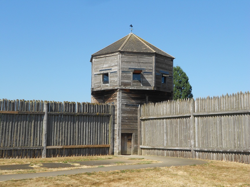
fort vancouver stockade
Bastion at Fort Vancouver
Fort Vancouver and the Hudson's Bay Company is arguably the most significant story about the very beginnings of commerce in the Pacific Northwest. For many years, Fort Vancouver was the headquarters of the British presence in what is now the states of Washington, Oregon and Idaho.

If your vacation or short trip plans take you to the Portland Oregon area, a visit to Fort Vancouver is a must stop. It's a beautiful site to visit and explains much of the very beginnings of settlement in the Pacific Northwest.


The British Stronghold in the Pacific Northwest

In a real sense the Hudson's Bay Company represented the British interests in the Pacific Northwest. The fur trapping company was the point of the spear as opposed to the British military. Fort Vancouver functioned as the main supply base and administration site in the American northwest for the Hudson's Bay Company which itself was headquartered in London England.

hudson bay company counting house at fort vancouver
Hudson's Bay Company Counting House
The British and the Americans both had trappers in the northwest for some time and an arrangement was made to allow trappers from both sides to share the region. The Hudson's Bay Company took a big step to solidify their hold by establishing Fort Vancouver. Fort Vancouver replaced Fort George which was at the mouth of the Columbia River at present day Astoria Oregon. Fort George had originally been called Fort Astoria when John Jacob Astor's fur company briefly occupied the fort. The Astoria fort and equipment were sold to the Hudson's Bay Company by Astor. Not long after they established Fort George, the Hudson's Bay Company decided to relocate further inland along the Columbia River. The new Fort Vancouver is in present day Vancouver Washington just across the Columbia River from Portland Oregon.

An interesting historic side note regards a man who served as Chief Factor at Fort Vancouver, John McLaughlin, who is credited as the founder of what is today Oregon City, Oregon on the Willamette River just a few south of Portland. McLaughlin had a fine reputation at the fort and was known to give aid to pioneers and trappers who arrived there in need. John McLaughlin also offered Oregon Trail pioneers food and medical aid which was against the official policies of the Hudson's Bay Company. Eventually, McLaughlin left Fort Vancouver and settled in Oregon City and built a sawmill on the east side of the Willamette Falls.

See our Western Trips article and photos of Oregon City.

hudsons bay company counting house
Counting House exterior
The Trappers Head Out

Beaver hats were very popular. The Hudson's bay Company sent out brigades which included perhaps 50 to 100. These included men, women and children. The earliest of trappers used the same methods as the Indians. This was breaking into a beaver lodge and simply taking the animals. Not soon afterwards, this gave way to the baited steel traps. After spending about a year away from the fort, the trappers prepared to journey back to Fort Vancouver.

Their arrival back at the fort was a time of celebration. The trappers and their boats arrived via the Columbia River with their pelts and wore some of their most colorful clothes. Their arrival was in the atmosphere of a festival.

The American Takeover

All stories of the famous Oregon Trail depict how thousands upon thousands of pioneers traveled this 2,000 mile route from Missouri to Oregon. Officially, the Oregon trail began in Independence Missouri and ended at Oregon City Oregon. American influence obviously grew in Oregon as more and more settlers arrived. As a direct result, the region was divided between the British and the Americans in 1946 at the 49th parallel. This division placed Fort Vancouver on American soil. The Hudson's Bay Company continued to operate at the fort for years afterward. At the same time in 1849 the U.S. Army established an outpost at the fort. The army named the fort Columbia Barracks and then renamed it Vancouver Barracks. The fur trade was declining for the Hudson's Bay Company and the U.S. was involved in various Indian Wars in the vicinity and throughout the west.  It wasn't until 1860 that they abandoned the fort altogether to the Americans. Six years later a fire destroyed all of the original fort.

fort vancouver fur warehouse
Fort Vancouver fur warehouse
The fort continued to be used by the U.S. Army through World War One and World War Two.During the First World War it was the home of the Spruce Division and in World War Two was the staging area for the Seattle port of embarkation.

Two additional Western Trips articles you'll find interesting are A Visit to Sutters Fort in Sacramento California and the Six Month Journey on the Oregon Trail.

Fort Vancouver Today

An excavation of the old site of Fort Vancouver took place beginning in 1947. According to National Park Service information, some two million artifacts were discovered at the excavation site. During the years during and after the excavation there were those who desired to keep the area an archeological site. In  1954, the area was was officially designated a site to preserve the history of the Hudson's Bay Company. In 1965 Congress gave the go ahead for a complete reconstruction. 

Fort Vancouver National Historic Site today is a reconstruction of the old Hudson's Bay fort as it would have appeared in the early 1800's. The reconstructed buildings within the Fort's walls are on their original sites. Adjacent to the fort is Pearson Field which today is operated as a city owned small aircraft field but does have the distinction of being the oldest operating airfield in the United States.

fort vancouver blacksmith shop
Fort Vancouver Nat'l Historic Site Blacksmith shop
Visiting Fort Vancouver National Historic Site

Fort Vancouver National Historic Site is easily accessible and makes a great addition to your Oregon western trip planner. The site is just across the Columbia River from Portland Oregon in Vancouver Washington. The two cities are connected by the Interstate 5 bridge. When on Interstate 5, turn off at the Mill Plain Blvd exit and follow the signs to the fort's Visitor Center which is on East Evergreen Blvd. At the Visitors Center you can obtain detailed maps which can be used for your walking tour. The Visitors Center is located on a hill just north of the fort. The walking tour map information contains details of each of the site's structures. 

The Fort Vancouver National Historic Site Visitors Center showcases interesting exhibits and offers visitors the opportunity to view several short films by request. It's one of the best sites to learn about the settlement of the Pacific Northwest.

(Photos from author's private collection)

Monday, October 8, 2012

Attractions in New Mexico

Off the Beaten Path New Mexico By Harris, Richard K. (Google Affiliate Ad)
sand bluffs at el malpais national monument
Sand Bluffs, El Malpais National Monument
Among the many attractions in New Mexico, the lava beds at El Malpais National Monument ranks as one of the most unique. El Malpais National Monument is located just southeast of Grants New Mexico and Interstate 40. This makes it one of the most easily accessible of all the National Monuments within the state. El Malpais translated into Spanish means "the badlands". The area was given that name because of the very rugged terrain.

The El Malpais National Monument Ranger Station is located about 98 miles west of Albuquerque and about 36 miles southeast of Grants New Mexico. It's a great addition to your New Mexico road trip planner being so close to Interstate 40.

Two additional articles on Western Trips with photos you'll be interested in are The Mining Museum of New Mexico and uranium mining located in Grants and the story of Hollywood on Route 66 in Gallup New Mexico.

lava beds in new mexico
Lava Beds at El Malpais
The Lava Beds at El Malpais National Monument

El Malpais is among the best monuments in the U.S. that showcases the results of massive volcanic activity. The lava flow at El Malpais is quite large, about forty miles north to south and twenty miles east to west. Driving on NM 117, which borders the east side of El Malpais, south of Interstate 40 takes you past the newest lava flow which came from McCarty's Crater sometime between 1,000 and 4,000 years ago. Because the climate is arid, the lava beds show very little water erosion. The lava flows in this area are one of the most significant found anywhere and comparable to those found in Hawaii. According to the National Park Service, the Malpais is home to more than 378,000 acres of lava rock,cinder cones, shield volcanoes and spatter cones.

The National Conservation Area which adjoins El Malpais is located is administered by the Bureau of land Management. El malpais itself is managed by the National Park Service. El Malpais National Monument was created in 1987 during the Reagan Administration although the idea of making it a National Monument went all the way back to the 1930's.

la ventana arch in new mexico
La Ventana Arch
Touring El Malpais on NM 117

Drive south on NM 117 and make your first stop at the Burea of Land Management's Ranger Station. Here you will find a large amount of information on the sites and trails available to visitors. There is also a short video available which will tell you a lot about the National Monument.When yoiu continue driving south of the Ranger Station, the fascinating Sandstone Bluffs will be your first stop. From these yellow sandstone cliffs you'll view the many cinder cones that line the horizon. Like many of the scenic stops along NM 117, you'll find it to be a great photo op site.

La Ventana Arch

A short drive further down NM 117 you'll come upon one of most fascinating geologic structures in the park. The La Ventana Arch is an excellent example of the erosive forces of nature. La Ventana Arch is known as the second largest natural arch in New Mexico at a height of 135 feet. The arch was created from eroding sandstone deposited during the age of the dinosaurs. You can easily see the arch from the roadway. There is a parking area and a short trail which leads to the base of the arch.Driving a short distance south on NM 117 you'll come up to the site of Lava Falls. You'll turn right on to a gravel road off of NM 117 and about a mile down the road is another parking area and a trail head. The short trail will have you walk over lava deposits which in itself is quite unique. The Lava Falls trail route is marked with large cairns. Explore the lava flows and see the plant life. Another great photo op area.

lava falls trail at el malpais
Along the Lava Falls Trail
Lava Falls

The Lava Falls site is the youngest of all the lava beds at El Malpais originating from McCarty's Crater. The lava beds you'll be walking over originally came up out of the earth and flowed before eventually becoming cold and came to rest in it's final form. According to information from the U.S. Geologic Survey, the lava flowing under the surface of a cooled surface layer results in pushed up features on large flow fields. The broken and fractured character of the lava, which you'll view on your hike, results from the shrinkage of the lava as it solidifies and cools. Interestingly enough, some of this same geologic action can be seen today at Hawaii Volcanoes National Park.

The Lava Tube System

El Malpais National Monument is also the home to lava tube cave systems. According to the U.S. geologic Survey, lava streams that flow steadily in a confined channel for many hours to days may develop a solid crust or roof and thus change gradually into streams within lava tubes.

 lava falls trail cairn el malpais national monument
A cairn marking the Lava Falls Trail
Because the walls and roofs of such tubes are good thermal insulators, lava flowing through them can remain hot and fluid much longer than surface flows. As the lava flows and then is cooled the result is often a cave. As of this writing, the caves at El Malpais are closed to the public. According to the NPS, the closure is due to a combination of factors including the outbreak of a fungal disease that is killing millions of bats that used the caves. The disease has been named "White Nose Syndrome". The NPS has also closed the caves to prevent continuing loss of delicate geological formations and the need to put into effect a cave management program to sustainably provide visitor access to caves while protecting them for future generations of Americans.

El Malpais National Monument is one the most interesting geologic areas in the southwest. It is one of the many attractions in New Mexico that is a must stop. If your western trip takes you into New Mexico you will be pleased to have added El Malpais to your road trip planner. It's one of those fun yet very educational stops along America's western highways and makes an excellent family vacation side trip.

(Photos from author's private collection)


Tuesday, September 25, 2012

Fort Point / California


fort point california
Fort Point under Golden Gate Bridge
You're visiting San Francisco California and there's so many things to see and do. Cable cars, Fishermans Wharf, Nob Hill, China Town, the Presidio, Telegraph Hill, Union Square and a host of other sites can easily fill most vacation trip planners. Add in the many popular and historic sites in Marin County, the wine country in Sonoma and Napa Counties and in the East Bay cities and you've easily created a week's worth of stops.

You'll be wise to add Fort Point to your itinerary. Fort Point is one of the most unique historical sites the the United States. One of the reasons this particular fort is so unique has to do in where it's located. The site of Fort Point is directly under the south end of the Golden Gate Bridge and in the Golden Gate National Parks area.. Stand inside or outside the fort gate, look up and you'll see the bottom of the bridge. There's nothing else like it. Today, Fort Point is a National Historic Site administered by the National Park Service.

The Creation of Fort Point 

fort point national historic site
Interior of Fort Point
Fort Point of course was at the mouth of San Francisco Bay well before the Golden Gate Bridge. This fort represents the story of the beginnings of California as well as US Army history.

There may not have been a better positioned fort to protect the bay entrance. The Spaniards, the first Europeans to arrive in present day San Francisco, built the Presidio as well as fortifying the cliffs where Fort Point is now located. The Spaniards were concerned with encroachment from the north by both the Russians and the British. The Russians had reached all the way south to around present day Bodega Bay, about 60 miles north of San Francisco. As it turned out, the Russian colony were traders not colonizers and there was never an armed conflict between the two.

As far as California was concerned, and at one time it was called Alta California, the biggest event was the United States takeover from Mexican rule in 1846.That event was followed fairly quickly by the discovery of gold at Sutter's Mill and then the ensuing California Gold Rush. Things changed dramatically and it changed fast. Tens of thousands of people arrived in the area, most of them by sea.

cannons at fort point
Cannon on display at Fort Point
Fort Point was constructed between 1853 and 1861 as a base to protect the bay. The decision to build the fort came in 1850 when California became a state. At that time a series of fortifications were planned to protect the very important and busy bay. The work was done by some 200 workers, many unemployed miners. At it's completion, the U.S. was in a Civil War and the fort was manned to protect against any possible Confederate attack. Military officials stated that the fort's position and sophistication with large brick walls (seven feet thick) at the San Francisco Bay mouth was the key to the whole Pacific coast.

As it turned out, the guns at Fort Point would never fire a shot during the war. According to information published by the National Park Service, there actually was a Confederate vessel, the CSS Shenandoah that did plan to attack San Francisco but on it's way learned that the war had ended. When the Civil War ended in 1865 the fort was garrisoned as a general army defense position as well as a barracks site.

fort point lighthouse
Lighthouse at Fort Point under Golden Gate Bridge
Another interesting fact according to the National Park Service was that the fort was actually renamed Fort Winfield Scott in 1882 but for whatever reason the name didn't stick. Eventually the name Winfield Scott was placed on an artillery post at the nearby Presidio. Winfield Scott was a national hero of the Mexican American War.

Two additional related Western Trips articles and photos you'll find interesting are the Sonoma California Mexican Barracks and Mission and also Sutter's Fort and New Helvetia.

Key Changes in 1892

As the years went by, many technological weapon changes took place. In 1892, the army started to construct new concrete and steel fortifications that would contain breech loading rifled guns. The era of the cannon was coming to an end. The 1906 Earthquake was obviously devastating to San Francisco and the fort wasn't entirely spared. Fortunately it was only moderately damaged. After the earthquake, Fort Point was mostly used for training and for barracks space although the members of the 6th Artillery Coast Guard were stationed there during World War two.

powder keg at fort point national historic site
Fort Point powder keg exhibit
Saving Fort Point

As happens occasionally with historic sites, their cultural importance sometimes conflicts with modernization. In the case of Fort Point it involved the planned Golden Gate Bridge. The actual plans for the bridge called for the removal of Fort Point. When you visit the fort, you'll see just how close the bridge structure is to the fort. Lucky for all of us the final plans for the bridge worked around the fort. You can see the changes in the Golden Gate Bridge construction and how it accommodated Fort Point.

The future of Fort Point was solidified when President Richard Nixon, in 1970, signed a bill officially making Fort Point a National Historic Site.

Directions to Fort Point

Fort Point is located at the end of Marine Drive on the Presidio of San Francisco. Getting there can be a bit tricky. If you're coming from San Francisco proper or points south of the Golden Gate Bridge, take Highway 101 north and exit right at the Golden Gate Bridge toll plaza but before getting on bridge. Turn right at end of exit ramp and then left onto Lincoln Boulevard. Take the first left onto Long Avenue and follow onto Marine Drive and Fort Point at its end. There is parking available before getting to the fort itself.

When you enter the fort you'll see a large brick fortification with several different replica models of cannon. Some of these are Spanish cannons. The fort has an extensive artifact collection including the powder storage room. It's quite an impressive display. You can also walk to the top of the fort and get a great view of the narrow opening between San Francisco Bay and the Pacific Ocean. Also a great place to get some unique Golden Gate pictures.

An excellent book regarding historic Fort Point is Fort Point: Sentry at the Golden Gate by author John Arturo Martini.

(Photos from author's private collection)


View Larger Map