Western Trips

Friday, November 29, 2013

Scenic Drives Near Deadwood South Dakota

The Black Hills of South Dakota and nearby Deadwood forever will a focal point of old west history. The Black Hills was disputed territory between the Sioux tribes and the U.S. Government which would in a large way lead to the last great Indian war on the northern plains.

Scenic Black Hills
Today, the Black Hills of South Dakota and the town of Deadwood are extremely popular tourist destinations. This is a prime area to visit if you're planning a South Dakota vacation. The town of Deadwood South Dakota is close to several National Historic Sites. Mount Rushmore, one of the country's most visited national monuments, is located only about 49 miles south of Deadwood. Gillette Wyoming, to the west of the Black Hills and to the east of the Bighorn Mountains and about 106 miles west of Deadwood, was one of the largest coal mining areas in the country and still offers coal mine tours . The town is also well known for it's rodeos. All of the drives from the Deadwood area are very scenic and make great day trips.

Black Hills Scenic Drives

Two scenic drives into the Black Hills and the one's closest to Deadwood are the Devils Tower and the Spearfish Canyon Scenic Drives.

deadwood gem theater
Historic Gem Theater, 1878, Deadwood, SD
Spearfish Canyon Scenic Byway

Visitors to Deadwood will find the Spearfish Canyon Scenic Byway being the closest of the two to Deadwood. The gorge you'll view along this drive is composed of limestone which dates back even further than the rock at the Grand Canyon. U.S. Hwy 14A passes through the Black Hills and around Spearfish Canyon for twenty miles. Viewing of the canyon is best either early in the morning or late in the day to see the many colors. Some people stop off at the old town of Savoy to begin trail hikes to old mines and logging camps and past waterfalls. You'll also see several original buildings still standing from Savoy's frontier days.

Your drive along this scenic byway can begin at Spearfish South Dakota which is just about a 15 mile drive northwest of Deadwood and just south of Interstate-90. Driving south on the byway from that point you can stay on U.S. Hwy 14A all the way until it meets U.S. Hwy 85 /14. This would be about twenty miles south of Deadwood making your day trip a circle drive. Along the drive you'll find plenty of places to turn off the highway to enjoy the scenery and take some good photos. One popular scenic stop along the scenic byway is Bridal Veil Falls and the falls can be seen from the highway. Bridal Veil Falls is on the northern section of the Spearfish Canyon Scenic Byway and about 7 miles south of the town of Spearfish.

The Spearfish Canyon Scenic Byway through the Black Hills is a must thing to do if you're trip plans take you to Deadwood.

devils tower wyoming
1900 photo of DevilsTower
Devils Tower

Devils Tower is a U.S. National Monument and has the distinction of being the nation's first National Monument designated by President Theodore Roosevelt in 1906. Devils Tower is located in Wyoming about a 75 mile drive west of Deadwood with much of the way via Interstate-90. The National Monument covers 1,347 acres.

Historically, like much of the Black Hills, the Devils Tower was a spiritual site claimed by Native Americans. When pioneers headed west several treaties including those regarding the Black Hills were violated. The entire area was actually overrun when word of gold in the Black Hills spread east. Although the U.S. Army attempted to keep prospectors away their sheer numbers made it impossible. Attempts were made by the government to buy the Black Hills from the Sioux but were unsuccessful. The Battle of the Little Bighorn in 1876 and the defeat of Colonel George Armstrong Custer had many of it's roots in the Black Hills controversy.

Devils Tower, an internationally popular tourist site, has a visitor center and a bookstore which is open year round. Ranger tours to the monument are led during the morning. Visitors can also opt for a self guided tour around the monument's base. Camping facilities are available at the park seasonally.The tower rises 1,267 feet from the landscape floor. The tower also draws climbers from the world around. The monument's acreage is covered by both pine forests and prairie grasslands including plenty of interesting wildlife such as pronghorn and black tailed prairie dogs.

You may also enjoy the Western Trips articles on the links below...

Drive the Chief Joseph Scenic Byway

Idaho's Sawtooth Scenic Byway

spearfish canyon scenic byway
Views along the Spearfish Canyon Scenic Byway
  Geologists determined that the tower itself rose from beneath the ground after erosion took away the softer rock layers surrounding it. The tower is comprised of magma that solidified not far below the earth surface. The monument's visitors center exhibits a lot of detailed information about this geologic wonder.

To celebrate Devils Tower 100 year anniversary, a sculpture called Circle of Sacred Smoke was added bear the sites picnic area.

(Article copyright Western Trips. Photos and images in the public domain)


View Larger Map

Friday, November 22, 2013

Travel the White Pass Scenic Byway

Picturesque views of Mount Ranier, Mount St. Helens and Mount Adams in Washington state's Cascade range are what fun trips to the Northwest are made of. Traveling the White Pass Scenic Byway is one great way to achieve this.

mount ranier viewed from tacoma
Towering Mount Ranier
The White Pass Scenic Byway, one of America's great Scenic Byways, spans from Yakima in central Washington in the east to the area of Interstate-5 and U.S. Hwy 12 to the west. Hwy 12 is located about three miles east of the Interstate off exit 68. The entire route is 119 miles and passes through both the Gifford Pinchot and Wenatchee National Forests.

The Three Highest Peaks in Washington State

The White Pass Scenic Byway is also known as Washington's Volcano Playground. This is known as Washington's volcano country. This is because all three of Washington's highest mountain peaks, Mount Ranier, Washington's highest, Mount St. Helens, a National Monument with it's jagged crater and Mount Adams all are part of your White Pass Scenic Byway experience.

Mount Ranier itself boasts twenty-six glaciers surrounding it. Mount St. Helens last erupted in 1980 that shot ash into the atmosphere that circled the globe. Mount Adams at 12,276 feet offers a real wilderness environment with alpine lakes that's enjoyed by campers during the non winter months. Hiking is spectacular in this area with both long and short trails offered. According to scientists Mount Adams last erupted circa 550 B.C.

mount adams washington
View of Mount Adams from Mount St. Helens
A Summer and Winter Playground

Rivers, lakes and waterfalls can all be seen along this scenic byway. Wildlife viewing, hiking, fishing and snowmobiling, downhill skiing, rock climbing are among the many recreational opportunities available.

One of the many picturesque lakes along the route is Rimrock Lake which is east of White Pass. The White Pass Scenic Byway (U.S. 12) passes right along the north shore of the lake where boating, good fishing and camping are very popular. Lakefront tent and RV camping among the stunning tall pines is available in all seasons.

Most suggest that the time required to travel over the White Pass Scenic Byway from end to end be at least six hours. To fully enjoy the scenery and attractions your trip can easily be longer than this. With the lodges and camping available along the route your trip can easily span days and would be well worth it.

White Pass Summit and U.S. Hwy 12

White Pass Summit is crossed by U.S. Hwy 12. The elevation is 4,500 feet and the roadway is open year around. Driving U.S. Hwy 12 over this scenic route offers an exceptional experience for young and old. The highway travels through alpine country, river valleys, foothills and several small towns.


white pass washington ski area
White Pass Ski Area
Skiing and snowboarding enthusiasts can enjoy the White Pass Ski Area during the winter season which is located in Naches WA off Hwy 12 and just south of Leech Lake. The ski area offers a variety of terrain and some good bump runs.The ski area is quite large and the atmosphere is friendly and unpretentious. The White Pass Ski Area has a reputation for good snow, no long lines and plenty of runs. One of it's biggest attributes is no crowded skiing.

The Gifford Pinchot National Forest

This National Forest is named in honor of Gifford Pinchot, personal friend of President Teddy Roosevelt's and the creator of the National Forest Service in the early 1900's. So much of the public lands set aside for  public enjoyment today was a direct result of both Pinchot's and Roosevelt's drive for conservation.

Pinchot served as the first chief of the National Forest Service and later was Governor of Pennsylvania for two non consecutive terms. During his tenure under Roosevelt, Pinchot, who had a good relationship with John Muir, eventually disagreed with the famous preservationist as to how national lands would be managed.

The Gifford Pinchot National Forest comprises nearly 1.4 million acres and includes the Mount St. Helens National Volcanic Monument.

The links below are to additional Western Trips articles you;ll enjoy...

The Sawtooth Scenic Byway in Idaho

Historic Route 66 Landmarks

The National Scenic Byways

A National Scenic Byway is a road or connection of roads that the U.S. Department of Transportation recognizes for it's history, natural resources, wildlife, scenery and archeological importance. The America's Byways program was established by the government in 1991 for the purpose of preserving these historic and scenic roadways along with providing maps and useful information for the traveler.


white pass scenic byway map
Red line is U.S. Hwy 12 through Washington
Included in these scenic roadways are National Scenic Byways and All-American Roads. There are some 150 of these spread across the U.S. White Pass Scenic Byway is included under the National Scenic Byways. Other Washington state Scenic Byways include the Chinook Scenic Byway to the north of White Pass and the Coulee Corridor Scenic Byway east of the White Pass route.

The state of Washington has no shortage of tourist destinations. From the seaport of Seattle to the volcanic mountains inland, the National Parks and Monuments and some of the most scenic wilderness areas found anyplace in North America, Washington has it all for the western traveler. The White Pass Scenic Byway is just one of the many scenic drives found in Washington.

(Article copyright Western Trips. Photos and images are public domain)


View Larger Map

Tuesday, November 19, 2013

Idaho's Sawtooth Scenic Byway

National Scenic Byways are a collection of diverse roads where adventure awaits. These scenic Byways are found all over the United States and offer some of the best scenery, geology and historic travels you'll find anywhere. The Sawtooth Scenic Byway in the beautiful mountainous state of Idaho is one such trail you'll want to add to your western trip planner.


sawtooth mountains idaho
Idaho's Sawtooth Mountains and Redfish Lake
The Sawtooth Scenic Byway

This 115 mile Idaho journey covers diverse terrain. Everything from the desert to the mountains. Start your trip in the town of Shoshone and take a picturesque drive to Stanley Idaho. The Sawtooth Scenic Byway is the 100th National Forest Scenic Byway in America and is in an area east of Boise and north of Twin Falls Idaho.

Black Magic Canyon

Along your journey on the Sawtooth Scenic Byway heading just a short way north from Shoshone you'll come to the Black Magic Canyon geological area. Managed by the Bureau of Land Management, the entrance to this area is off Hwy 75 by both paved and gravel roads. Here you'll enjoy the sculptured rock and the black basalt. The Black Magic Canyon, carved by the Big Wood River, offers one of the finest examples of eroded river bedrock in the U.S. All of this is the result of thousands of years of erosion and a protected area today due to the efforts of the BLM during the 1990's to keep these historic rocks away from mining claims.

Hailey, Ketchum and Sun Valley

Your drive on the Sawtooth Scenic Byway will take you through the towns of Hailey, Ketchum and Sun Valley Idaho.

Hailey is a four seasons destination in the Rocky Mountains. Located in central Idaho, Hailey is in the Wood River Valley. It's a hiking, biking and skiing destination and is surrounded by the Sawtooth National Forest.

american falls dam in idaho
Sawtooth American Falls Dam
Located in central Idaho about eleven miles north of Hailey on Hwy 75 is the town of Ketchum Idaho. Here you'll find art galleries, great scenery and you're just a couple of miles away from Sun Valley.

Among things other than great outdoor recreation, Sun Valley Idaho was the residence of author Ernest Hemingway. On Trail Creek Road just north of Sun Valley and one mile east of the lodge is the Ernest Hemingway Memorial. The memorial was built in 1966 by Hemingway's family and friends and features a bronze bust of the author. The memorial is open year round.

Redfish Lake

The alpine Redfish Lake is located in the Sawtooth National Recreation Area in Custer County Idaho. The lake got it's name after the Sockeye Salmon that at one time returned there from the Pacific Ocean and in such enormous numbers that the lake took on a red glow. While the Sockete salmon is now an endangered specie, this beautiful mountain lake is home to great recreational opportunities with lodging, boat rentals and camping being large tourist draws. Redfish Lake is located west of Hwy 75 and just about seven miles south of Stanley Idaho, the northern terminus of the Sawtooth Scenic Byway.

idaho salmon river canyon
A 1945 view of Sawtooth's Salmon River Canyon
Stanley Idaho

Stanley Idaho, located between the Salmon River and the Sawtooth Mountains, is at the northern end of the 115 mile long Sawtooth Scenic Byway. The town sits in a very picturesque part of Idaho with the Sawtooth Mountains as a background. The area was first visited in the early 1800's by fur trappers from the Hudson's Bay Company. The town is named after a Civil war veteran named John Stanley who led a group of gold prospectors through the area.

Stanley and the surrounding area offer unique shops and restaurants, hiking and biking opportunities as well as fun river rafting adventures. If you travel to Stanley you'll want to see the Sawtooth Hotel that was established in 1931. The hotel features old country style mountain lodging and dining and has been doing this ever since it's opening over eighty years ago.

Two additional scenic drives are featured on the Western Trips articles linked below...

The Beartooth National Scenic Byway

A Drive Along the Columbia River Gorge

boise state capital
State Capitol, Boise Idaho
More Idaho Scenic Byways

At the northern end of the Sawtooth Scenic Byway at Stanley Idaho, adventurers have the opportunity to enjoy additional scenic and historic drives. Going east and northeast out of Stanley is the Salmon River Scenic Byway. The northern end of this drive is at the Montana border. This was an area visited by the Lewis and Clark expedition in the early 1800's.This route follows the Salmon River through the Salmon-Challis National Forest.

Going west and southwest out of Stanley Idaho is the Ponderosa Pine Scenic Byway. The route runs between Stanley and the state capital of Boise. On this route you'll have a chance to pan for gold in Idaho City. The Ponderosa Pine Scenic Byway cuts through two Idaho wilderness areas, the Sawtooth Wilderness Area and the Salmon-Challis National Forest. You'll find plenty of campgrounds and have excellent fishing opportunities along this Scenic Byway.

(Article copyright 2013 Western Trips. Photos and images are in the public domain)

Monday, November 11, 2013

The Best Military Museum in Texas

For those making a western trip through Texas, consider making a stop at a very unique military museum located in the state capital of Austin. Not only is this a fun and educational venue to visit but it's also free and I believe you'll find it the best military museum in Texas.

texas military museum
L-21A Aircraft
The Texas Military Forces Museum and Camp Mabry

The Texas Military Forces Museum is located at Camp Mabry in Austin Texas. Camp Mabry serves as the headquarters for the Texas Military Forces and is an active military base.

The Texas Military Forces are the three-branch military of the state of Texas. It includes the Texas Army National Guard, the Texas Air National Guard, and the Texas State Guard. Photo identification for all adults is required to enter the base to access the museum.

Camp Mabry is named for Brigadier General Woodford H. Mabry, the Adjutant General of Texas from 1891 to 1898. During the First World War Camp Mabry was utilized by the U.S. Army as a school for automotive mechanics. During World War II the camp was headquarters for the Texas Defense Guard.

Another interesting historical fact concerning Camp Mabry is that it is the third oldest military facility in Texas. The older two include Fort Sam Houston and Fort Bliss.


japanese map case world war two
Japanese map/dispatch case, circa 1940
You may have already visited other military museums but at the Texas Military Forces Museum there's a good chance you'll see some exhibits not found anywhere else. For starters, the museum has a very extensive World War Two collection containing a hat from the German General Rommel.

A Large and Unique Collection

The museum is both inside and outside. On the grounds you'll view World War Two tanks and artillery pieces to a modern day Abrams MBT.Also outside is a collection of attack helicopters and fighter jets.The Artillery Park behind the museum building displays guns from World War One, World War Two and the Korean War.

Inside the museum are displayed several interesting vehicles. These include a M4A3, Hetzer, Jeep, Kubelwagen, M3 halftrack, a several additional U.S. trucks and light vehicles. Pictured in this article is an M 37 three quarter ton truck as well as a M151A MUTT jeep which was produced by Ford Motor Company, Kaiser Jeep and AM General Corporation. The MUTT saw a lot of service in Vietnam,


m 37 army truck
M 37  3/4 ton truck
The time frame covered by the Texas Military Forces Museum spans from the Texas war for Independence in the 1830's to the present day war against terrorism. Hard to find another such museum with this scope. Enjoy the museum's artifacts, videos, photos and dioramas. Among the dioramas are World War One and World War Two battle scenes. The museum adds new exhibits each year.

Talk about unique. The Texas Forces Military Museum has two aircraft hanging form the ceiling as part of their indoor exhibits. The L-21A Liaison plane is one such exhibit. The L-21A was a plane manufactured by Piper and was essentially a Piper Cub. One hundred and twenty-five of these planes were built. The planes nickname was "Grasshopper" and had an overall length of 22 feet 7 inches and a wingspan of 35 feet 2 inches. The L-21A's range was about 770 miles.

Visiting the Texas Military Forces Museum

The museum is located in Building 6 at Camp Mabry. For large groups (more than 15) guided tours are available. To arrange these call 512-782-5659 between 7 a.m. and 5 p.m. Monday through Friday.

f 16 trainer
F-16 cockpit egress trainer
To drive to the museum, exit MOPAC Expressway at 35th Street. Drive west until you see the signs for the entrance to the base. This is further west than the old main entrance that was closed several years ago.

 The general area of Camp Mabry is about three miles northwest of the state capitol building and northwest of the University of Texas campus, Austin Texas. The address of Camp Mabry is 2200 West 35th Street.

Research

Research requests are accepted at the museum during weekdays 7A to 5P. In addition the museum's research library the Texas Military Forces Museum holds the service cards for every Texan who served during World War I. This is a total of about 30,000 cards. These cards serve as a summary for World War I veterans enlistment, service and discharge. The museum's research facilities also serve as a source for tracing family trees of veterans who fought for Texas.

Personal papers are also archived at the museum. Included are memoirs by members of the 36th Division. Photo resources include over 7,000 images.

The Texas Military Forces Museum's extensive research library contains over 20,000 books.

The links below are to additional Western Trips articles you'll enjoy...

Austin Texas' Historic Driskill Hotel

Historic Fort Stockton Texas

A World Class Austin Texas Museum

m 151 mutt army jeep
M 151A MUTT
On our Trips Into History Site see our article on the California State Military Museum in Sacramento.

A visit to the Texas Military Forces Museum is a fun activity for the entire family and you just mind find it to be the best military museum in Texas. The exhibits are vast and cover over 150 years of Texas military history and military history in general.

Artifacts, military equipment, historic photos and a premiere research facility are all at the Texas Military Forces Museum at Camp Mabry in Austin Texas. Admission to the museum is free. Donations to help with it's operation are greatly appreciated.


 If you're visiting central Texas and the Austin area a trip to this museum is very well worth your time.

(Article and photos copyright 2013 Western Trips)


View Larger Map

Friday, November 8, 2013

Traveling on the Old Spanish Trail

It was an ancient trail and to the Spaniards it meant a vital trade route between their colony in Nuevo Mexico and Alta California. Interestingly enough, this strategic trail is one of least known of the historic trails of North America. Like many of the old western trails, this trail through America's southwest brought Europeans in contact with many Native American tribes for the first time.


old spanish trail map
The Old Spanish Trail route
 The Old Spanish Trail actually predates both the famous Santa Fe Trail and the Overland Trail traversed by many of the pioneers heading west beginning in the 1840's.

The trail that we refer to as the Old Spanish Trail was, for the most part, originally used by ancient Native Americans. It were largely these ancient trails that connected to form the trail used by the Spaniards as early as 1670.

The Old Spanish Trail, some 1,120 miles in length, while used by the Spaniards for commerce and migration as well as for transporting Native American slaves, dates to the late 1600's. It was not until about 1830, after the Spaniards had left North America and the Mexican government was formed that the trail was used as a regular commercial route.

The Mormans used the western part of the trail beginning in the 1840's as a wagon route for settlers heading west. The Mormon presence on the Old Spanish Trail disrupted the transportation of slaves over the route.  That part of the trail is also referred to as the "Mormon Corridor".


old los angeles
Los Angeles plaza, 1869
A Winding Route to California

The Old Spanish Trail was anything but a straight line. Leaving Santa Fe New Mexico, the route traveled west/northwest toward Utah. What was being circumnavigated were the Grand Canyon and the Glen Canyon, two obstacles that were too formidable to cross. The north branch of the trail crossed the San Luis Valley in present day southern Colorado.

Heading westward the trail crosses central and southern Utah where it took another turn to the south. The present day town of Ucolo Utah is where the Old Spanish Trail entered that state. The trail crosses the Colorado River near the present day town of Moab Utah. The next river crossed in Utah was the Green River.

The trail continues to the north of San Rafael Swell and reached it's northernmost point in present day Emery County Utah. After that the Old Spanish Trail runs across the Great Basin  and through the Mojave Desert on it's way toward Los Angeles.

santa fe plaza new mexico
Palace of the Governors, Santa Fe plaza
In 1829 the Armijo Route segment of the trail was established that followed a more westward direction crossing southern Utah and northern Arizona and originated near Abiquiu New Mexico. There were also branches of the Old Spanish Trail that had it going north from Santa Fe to Taos and then into Colorado and the San Luis Valley. Another branch went more northwest from Santa Fe through a settlement named Abiquiu and then northwestward toward present day Durango Colorado.

Woolen goods, mostly blankets and rugs were transported west by the New Mexicans which during that period was referred to as Nuevo Mexico. The largest traffic on the reverse route eastward were horses and mules.

Old Spanish Trail Historic Sites to See Today

Today, the Old Spanish National Historic Trail covers the states of New Mexico, Colorado, Utah, Arizona and California. Santa Fe New Mexico itself served as a hub since it tied in directly with the Santa Fe Trail connecting to eastern markets.

There are museums and historic sites all along the way that can be fun additions to your next western trip. The trail is so lengthy that starting from any location such as Santa Fe, New Mexico; Alamosa and Durango, Colorado; Las Vegas, Nevada; St. George, Utah; Flagstaff, Arizona; and Los Angeles will work well.

More Western Trips photo articles of interest are on the links below...

The Pueblo Revolt and the Spaniards

The Ancient Cliff Dwellings in Colorado


alamosa colorado
Alamosa Colorado
Points of interest along the trail today include the Homestead Museum in the City Of Industry California (Los Angeles area) which was once part of a 49,000 acre rancho.

Another good museum to add to your western trip planner is the Museum of Moab in Moab Utah which displays many historic artifacts from the Old Spanish Trail days and before.

The San Luis Valley Museum in Alamosa Colorado has a large amount of information and exhibits about San Luis Valley history and it's Hispanic and Native American heritage.

Thirty miles west of Green River Utah is the San Rafael Swell. This geologic formation is managed by the Bureau of Land Management and as of this writing discussions are ongoing about making the area a National Historic Monument. Backpackers, hikers and horseback riders all enjoy exploring this beautiful part of Utah.

Historical markers along the old trail can be seen at Lake Las Vegas Nevada in the Las Vegas Valley.

Historical marker is seen at Cottonwood Draw Utah between Utah RT 6 and Green River Cut-off , in Parowan Utah and in Grand Junction Colorado.


san rafael swell
San Rafael Swell Utah
Wagon and mule tracks can still be seen in the Mojave Desert on and west of the Alvord Mountains and in several sections east of Barstow California.

There are chapters of the Old Spanish Trail Associations in several communities along the way. These include the Southern Utah Chapter and the San Luis Valley Colorado Chapter. Additional information about the Old Spanish Trail and current events along the route as well as preservation efforts can be found at website www.old spanishtrail.org.

(Article copyright 2013 Western Trips. Old Spanish Trail route map image, 1869 Los Angeles plaza and San Rafael Swell photos from the public domain. Santa Fe plaza and Alamosa Colorado from Western Trips collection)

Tuesday, November 5, 2013

A Visit to Historic San Luis Colorado

San Luis Colorado with the motto: "The Oldest Town in Colorado" is a beautiful and historic place to visit. Nestled in scenic south central Colorado, a short distance north of the border with New Mexico, San Luis was a part of the New Mexico Territory until 1861 when the Colorado Territory was established. This was at the same time that Congress granted Kansas statehood.


san luis colorado
Mural in San Luis Colorado
The Settlement of San Luis

As mentioned above, the settlement of San Luis was at one time within the New Mexico Territory when the U.S. took control in the late 1840's. Prior to that the settlement was within Spanish and later Mexican Nuevo Mexico. The Spanish explored into present day Colorado as early as 1540. The Mexican government only ruled the territory for a few decades in the 1800's before the Mexican American War. As a direct result of that war Mexico ceded the region.

San Luis today is primarily a Hispanic settlement that was originally populated in 1851. This would have been just a few years after the Mexican American War and still a part of the New Mexico Territory. Historically, this is also an area of the expedition of Zebulon Pike

Land grants attracted many people to today's southern Colorado although the settlers at first had to withstand raids from Ute Native Americans of which this land was a part of their ancestral grounds. Many tribes did inhabit Colorado at various times includung the Comanche, Cheyenne and Arapaho.

A good book regarding Colorado Territory history is The Rise of the Centennial State: Colorado Territory by author Eugene H. Berwanger.


shrine of the stations of the cross
The Chapel of All Saints on top of the mesa
Visit San Luis Colorado and the Colorado-New Mexico Border Region

A visit to San Luis is a perfect companion trip to several other northern New Mexico and Southern Colorado tourist destinations. San Luis is about 63 miles north of Taos New Mexico and about 45 miles south of the Great Sand Dunes National Park.

Shrine of the Stations of the Cross 

In addition to being the oldest town in Colorado San Luis has another thing to offer. Take a stroll up a part paved part dirt path up a hillside on the edge of San Luis Colorado and you'll be experiencing the truly unique Shrine of the Stations of the Cross. Here you will find a spot that reflects the culture of the area.

Walking on this path some 8,000 feet above sea level could be one of the most unique walks you'll take.  The route is about three quarters of a mile long. The Shrine of the Stations of the Cross is located on a mesa and along your walk you'll pass by a several bronze statues.These statues depict the last hours of the life of Christ. Each station along your journey up the mesa will highlight a different scene. On top of the mesa is the Spanish-Moorish styled Chapel of All Saints. The chapel towers over the valley.

You will pass fifteen different stations along the way with the last one depicting Christ's resurrection. Models of the sculptures are also in a collection at the Vatican in Rome Italy.

san luis colorado shrine
A view at the beginning of the walkway
The Sculptor

The sculptor of these unique bronze statues was Huberto Maestas. Works of Maestas are located throughout the world. His work is in both public and private collections.

His sculptures at the Shrine of the Stations of the Cross were made at two-thirds life size. The Crucifixion and the Resurrection statues are life size.

Many Historic and Fun Sites Near San Luis Colorado

As mentioned above, a visit to unique and scenic San Luis Colorado can be a good addition to the many other scenic and historic sites in the area. These include the historic site of Fort Garland Colorado, about 16 miles north of San Luis.

The art community of Arroyo Seco New Mexico is about a 64 mile drive south of San Luis and just a few miles south of it is beautiful Taos New Mexico.

Below are links to Western Trips photo articles covering a few more interesting sites near San Luis Colorado...

The Art and History of Arroyo Seco New Mexico

Historic Frontier Fort Garland Colorado


things to do in san luis colorado
Entrance way to the Shrine of the Stations of the Cross
An interesting side note, and a topic that has been reported on in length, the San Luis Valley of southern Colorado is a UFO hot spot. At least it is to some observers. Many of the locals tell of UFO stories. Supposedly there have been documented UFO sightings in the valley as far back as the year 1600.  Today the San Luis Valley is considered a national UFO hot spot.

 If you're in the area and into UFO's make sure to check out the UFO Watchtower in Hooper Colorado. This is a rectangular shaped tower standing ten feet above ground that can accommodate sixty people at a time. There have also been about the same number of sightings, cigar shaped strange objects with lights, since the tower's opening. Hooper Colorado is located about 59 miles northwest of San Luis Colorado and about 20 miles north of Alamosa Colorado.

(Article and photos copyright 2013 Western Trips)


View Larger Map
Sunday, November 3, 2013

A Visit to a Cowtown Called Fort Worth

Fort Worth Texas rightly gained the nickname "Cowtown" and for a very good reason. Here was a spot in northern Texas where herds of cattle poured through on their trip north. Cattle from many branches of the old Chisholm Trail made their way through Fort Worth on their journey to the all important railheads.

chisholm trail fort worth
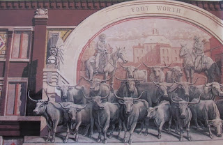
Chisholm Trail Mural
When the Spanish pulled out of their northern colony in the early 1800's thousands of heads of cattle roamed freely all throughout Texas. This was the era before barbed wire and homestead acts. This was the wide open frontier literally with boundaries.  Later, the American Civil War essentially put a halt on cattle exportation out of Texas aside from efforts to supply a Confederate army to the east. When the Civil War ended, the cattle herds had multiplied tremendously and the era of what we know of as that of the great cattle drives in and out of Texas was born. The Chisholm Trail played a major role in this new and profitable industry.

If you drive through Texas today, take a look at Interstate 35 on your road map and you'll see the route of much of the old famous Chisholm Trail.

Visiting Fort Worth Texas

Take a walking tour or leisurely drive through Fort Worth today and you'll see a great many reminders of what made this town, now a major city, into the fascinating historic site it is. Below are listed several areas and sites of Fort Worth you'll want to add to your trip planner.


attractions fort worth stockyards
Fort Worth Stockyards carriage rides
If you're visiting Dallas and want to make a day trip to Fort Worth the TRE commuter train gives you an easy and low cost way to do that. The TRE train can be boarded at the Union Station in downtown Dallas and arrives in downtown Fort Worth at the Intermodal Transportation Center.

Sundance Square

Located in the heart of downtown Fort Worth, Sundance Square is an area of hotels, shops, some excellent restaurants. Sundance Square is bordered by Taylor Street, Grove Street, 1st St. and 5th St. Sundance Square is also the home of some interesting murals such as the Chisholm Trail Mural shown in this article. This three story tall mural is seen on the old 1908 Jett Building. The mural was created in 1988 and commemorates the Chisholm Trail cattle drives between 1867 and 1875.


tarrant county courthouse
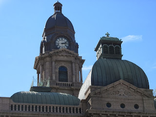
Tarrant County Couthouse, Fort Worth TX
The Tarrant County Courthouse

The Tarrant County Courthouse in downtown Fort Worth Texas was completed in 1895 after two years of construction. Made from pink granite from central Texas, the courthouse sits atop a bluff above the Trinitiy River and at a spot near where the original military fort was established in 1849 and manned by the 2nd U.S. Dragoons. The military outpost of Fort Worth had a relatively short lifespan closing in 1853.

One of the most interesting stories regarding the courthouse's construction had to do with it's cost. The very impressive structure was built for a little over $400,000. In the 1890's this was obviously a large amount of money. Even though the cost of construction came in under it's budget, the voting public in Fort Worth felt that this was a tremendous waste of money. The sentiment was so strong that the entire Commissioner's Court and the County Judge were ousted from office. While this certainly was a drastic measure at the time, the Tarrant County Courthouse was eventually realized for the beautiful architectural masterpiece it is.


texas courthouse architecture
Renaissance Revival architecture
The Biggest Stagecoach Hub in the Southwest

Fort Worth Texas became the largest stagecoach hub in the southwest after the tracks of the Texas and Pacific Railroad reached town in 1876. If you were heading west you might take the train to Fort Worth and transfer to one of the many stagecoaches going further west and southwest. This could very well have been your itinerary heading to El Paso, Tucson Arizona or California.


Fort Worth Stockyards

Probably no better place in Fort Worth to get the feel of the old west cattle drive days. The Fort Worth Stockyards attract visitors from all over the world. Enjoy steers being driven through the stockyard area twice daily by authentic cowboys. The stockyard area was once home to both Armour and Swift packing plants during the first half of the 1900's.

stockyards in fort worth
The Fort Worth Stockyards is a National Historic District located about six miles north of the central business district off N. Main Street.

The links below will take you to our Western Trips visit of the Fort Worth Stockyards with photos and history and our article on Cowboy Gear...

Cattle Drives and the Fort Worth Stockyards

Cowboy Gear for the Cattle Drive

The Cattle Raisers Museum

Another great place to visit to get the feel of the old "Cowtown" is the Cattle Raisers Museum which opened in 1980. Located at 1301 W. 7th Street, the Cattle Raisers Museum offers cowboy and ranching artifacts and a good many interactive exhibits. This 10,000 square foot museum is dedicated to preserving the history of the cattle industry. The museum tells the fascinating story of cattle ranching, cowboys and cattle drives from the 1850's to the present day.

(Article and photos copyright 2013 Western Trips)


View Larger Map