 |
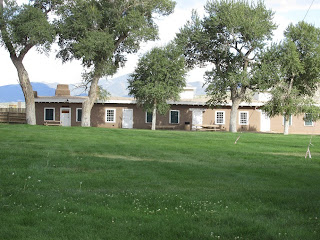
| Restored adobe structures from parade ground |
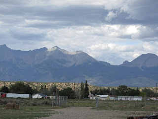
Western Trips had the opportunity to explore the southern Colorado military outpost of Fort Garland. Fort Garland was established in 1858, about a decade after the U.S. took possession of the southwest from Mexico, to protect settlers in the San Luis Valley. This area of Colorado is a particularly scenic part of a very scenic state. Fort Garland is also just south of towering Blanca Peak which has an elevation of 14,345 feet. Blanca Peak is the highest peak in all of the Sangre de Cristo Mountains.
Southern Colorado's Unique Tourist Sites
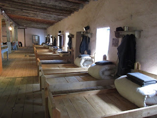
Fort Garland is an excellent addition to your southern Colorado trip planner and it's near to several other popular tourist destinations. This old frontier fort has a vast array of 1800's artifacts including a large collection of frontier firearms and furnished barracks as they would have looked in the 1800's.
Fort Garland is located about 25 miles east of Alamosa Colorado, 78 miles north of Taos New Mexico and about 90 miles southwest of Pueblo Colorado.
 |
| Fort Garland infantry barracks interior |
The link below is our Western Trips photo article on the Great Sand Dunes National Park.
The Great Sand Dunes
Another fun family activity nearby in Alamosa Colorado is the Rio Grande Scenic Railroad. This excursion train rides from Alamosa to La Veta Colorado and a connection to the Cumbres and Toltec Railway which offers scenic rides to Chama New Mexico. The Rio Grande Scenic Railroad route takes you through fascinating mountain country that's not seen from the highway.
 |
| Display of 1800's carbines |
Fort Garland is considered the gateway to the San Luis Valley. The San Luis Valley is an agricultural area about 125 miles long and 50 miles wide. The highly productive valley receives it's irrigation from the Rio Grande and from artesian wells which makes it the most productive agricultural valley in all of Colorado. Lettuce, barley and Red McClure potatoes are some of the main crops shipped out of the San Luis Valley.
The San Luis Valley is a unique region. The valley lies in elevations above 7,000 feet and in many respects is a high desert but lies above aquifers. The valley had been occupied for centuries by Native Americans and then by the Spaniards. By the end of the 1800's most of the valley had been cultivated by the many settlers who arrived from the east after the end of the Mexican American War.
Fort Garland and the Sangre de Cristo Land Grant
Fort Garland has a very rich history which has been preserved and on display at the fort museum. The fort itself was built on land leased from the Sangre de Cristo Land Grant which was part of a system to reward land during the times of Spanish and Mexican occupation of North America. At the time of their occupation of the southwest, Colorado was part of Nuevo Mexico with it's capital being in Santa Fe.
 |
| View toward Blanca Peak |
As it turned out after the Americans took over this territory as well as California, there were many disputes regarding the land grants awarded simply because the Spanish and Mexican systems were so different than the American method of land ownership. It's interesting to note that there still remains disputes of land ownership in the U.S. as a direct result from these early Spanish and Mexican land grants.
In particular, the Mexican's who inherited the Spanish administration after 1821, allowed for French, British, and American born men to own land so that they essentially became the large landowners in Mexico. All that was required of the land recipients was to pledge to defend Mexico against American westward expansion.
Fort Garland and Kit Carson
As an active U.S. military fort, it leased land from the historic
Sangre de Cristo Land Grant. - See more at:
http://www.historycolorado.org/museums/history-fort-0#sthash.JPKjcwJ8.dpuf
When Fort Garland was established by the War Department in 1858, the area where the fort would be established was in the Territory of New Mexico. Fort was built to replace Fort Massachusetts which had been built six miles to it's north. Fort Massachusetts happened to be built in what was soon determined to be a poor defensible position therefore the establishment of Fort Garland was needed as a replacement. The fort was named after the Commander of the Department of New Mexico, John Garland.
 |
| Cavalry Officer's hat exhibit |
Kit Carson died just one year after his Fort Garland command ended. Carson died in 1868 at nearby Fort Lyon at the age of only 58 of what was described as a abdominal aortic aneurysm. He was buried near his home in Taos New Mexico.
Visitors to Taos today can take a tour of the old Kit Carson home which is also a museum. The home and museum is located just a short walk east of the Taos Plaza. Kit Carson's grave site is a short walk northeast of the home.
Below are links to a Western Trips photo articles regarding Kit Carson and Taos New Mexico.
Kit Carson and Taos New Mexico
Kit Carson and a Trip Through the Navajo Nation
 |
| Fort Garland frontier pipe and tobacco exhibit |
During the Civil War Fort Garland was utilized as an enlistment point for Colorado Union Volunteers. Some of the troops put together at Fort Garland fought in the key Battle of Glorieta Pass, a site just to the east of Santa Fe New Mexico and along present day Interstate 25.
The battle was key in that it turned back General Henry Sibley and his Confederates who were attempting to travel north and attack the important Fort Union along the old Santa Fe Trail. Up to thae point of the battle, Sibley had occupied both Albuquerque and Santa Fe. The Union victory at Glorieta Pass checked the Confederate advance and forced their eventual withdrawal from all of New Mexico Territory.
Fort Garland is located at a point in southern Colorado that makes it very easy to combine a visit their to other fine tourist destinations. Taos New Mexico is just 78 miles to the south. Santa Fe New Mexico is just another 65 miles south of Taos and to the west is Alamosa Colorado with the Great Sand Dunes National Park and two very popular National Wildlife Refuges and the Rio Grande Scenic Railroad.
(Article and photos copyright 2013 Western Trips)
View Larger Map

