Western Trips had the opportunity to take an enjoyable and historic walking tour of downtown Round Rock Texas. There are of course many historic towns in Texas and Round Rock certainly has it's share of interesting stories.
 |
| Round Rock's Palm House Museum |
The downtown Round Rock Historic Commercial District was added to the National Register of Historic Places in 1983. The Round Rock Historic District consists of the buildings fronting the 100 and 200 blocks of E. Main Street and the Old Post Office/Masonic Lodge at 107 S. Mays Street.
Below is information on just a handful of historic buildings in downtown Round Rock Texas. There are a great many historic structures all around Round Rock which makes it a good stop while traveling through the area. If you're traveling to Austin or San Antonio on Interstate 35 a stop in Round Rock is time well spent.
Palm House Museum
Round Rock's Palm House Museum is at 212 E. Main and was the former home of Andrew J. Palm who migrated to Texas from Sweden in 1853. The home was constructed by Palm about three miles north of Round Rock in 1873. The home was moved to it's present site in downtown Round Rock in 1976. The home was designated a Texas Historic Landmark in 1978.
 |
| Old Williams Grocery Store historic building |
Round Rock Mercantile and Economy Drug Store
From 1877 to 1884 Peters and Brothers operated a mercantile store at this site. After that the structure was used as a meat market and then a blacksmith shop. In 1907 the current structure was built and operated as a mercantile store and the Economy Drug Store. In 1910 a fire destroyed a good deal of the building. The store was repaired and was operated as a dry goods store. A grocery store operated in the building until 1979. Today you can see the store's original display case and soda fountain counter. The address of this structure is 202 and 204 E. Main St.
J.A. Nelson Building
This building located at 201-203 E. Main Street was one of Round Rock's largest downtown stores. A fire in 1879 destroyed the entire block. At that time a store was operated at the site but a new building was built on two lots by W.T. Cox who then sold the building to partners Steinberg and Blair. One store on the site was purchased by a man named Dooley who ran the town's largest hardware store.
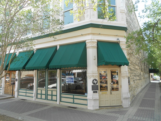 |
| J.A. Nelson Building |
Williams Grocery Store
This structure was built in 1876 and sold to S.P. Williams who operated a grocery and dry goods store here beginning in 1881. New ownership arrived in 1903 and after that the building served as an office, a five and dime In later years Walsh Television and Appliance and Round Rock Plumbing and Electric Company operated here from the 1960's to 1974. The address is 103 E. Main Street.
Links to four Western Trips photo articles you'll also enjoy include:
Historic Salado Texas, just north of Round Rock along Interstate 35 and also a town where the old Chisholm Cattle Trail passed.
A Visit to Old Town Round Rock Texas
A World Class Austin Texas History Museum
Lockhart / History and the Barbecue Capital of Texas
 |
| Another view of the restored J.A. Nelson Bldg |
Today, Round Rock Texas in Williamson County is essentially a northern suburb of the greater Austin area. The entire Austin area including Round Rock have grown tremendously.
Round Rock actually has it's roots dating back to 1851 when a settlement was established along the north shore of Brushy Creek. The first settlement there was named Brushy. This was the area today which is referred to as Old Town and was on a feeder to the Chisholm Cattle Trail leading from south Texas north into Kansas. The Old Town area is also referred to as Old Round Rock.
The International-Great Northern Railroad came through the county in 1876. The tracks were built to the east of the original settlement (Old Town) and it wasn't long until just about all commercial enterprises located themselves in this new section. After the railroad arrived so did several new hotels. This is the site now called downtown Round Rock. This is the reason that many of the old historic sites in downtown Round Rock shown in this article were established in the years just after 1876. Wherever the railroad laid tracks commercial development soon followed.
 |
| Johnson Drug Store Building |
One last side note is that there actually is a round rock in Brushy Creek that the town got it's name from. The round rock is found in the middle of the creek. Where the rock is located was used as a good place to cross the creek for both Native Americans and cattle and stagecoaches. Today you can still see some of the wagon ruts on rocks in the area. The first bridge was constructed across Brushy Creek in 1890.
(Photos from author's private collection)
View Larger Map