Western Trips

Friday, September 28, 2012

The Columbia River Gorge


columbia river gorge
Columbia River view from Scenic Highway

As scenic highways and byways go, the Columbia River Scenic Highway is one the best in the United States. If you have the opportunity to travel to Oregon on your next western road trip, this is a trip you want to experience.

The Columbia River Gorge is a truly unique region in the Pacific Northwest. This is an area of high cliffs, cascading waterfalls and thick pine forests all intermixed with the colorful history of the famous Lewis and Clark Expedition. The scenic Columbia is the Mississippi of the west coast. It is the largest U.S. river emptying into the Pacific Ocean.

The Roadway of the Immigrants

The Columbia River made up one of the most important segments of the old Oregon Trail. This is the river that immigrants took their chances rafting down to what would become their new homes. In fact, before the Barlow Road opened up in 1846 around the south side of Mount Hood, the perilous and scenic Columbia was The road from The Dalles to present day Portland at the mouth of the Willamette River.

This was not an easy trip. Lives were lost making the journey west of The Dalles. Most immigrants were not naturally skilled rafters and what the Columbia River could throw at them would tax their skills to the max.The destination for most of the immigrants was Oregon City along the Willamette River just a few miles south of Portland.

Two additional Western Trips articles with photos you'll find interesting are Historic Oregon City and Astoria Oregon at the mouth of the Columbia River.

multnomah falls benson bridge
Benson Bridge at Multnomah Falls
The Scenic Highway

The Columbia River Highway was built between the years of 1913 to 1922. This scenic Oregon highway spans some seventy-five miles along the south shore of the Columbia River from Troutdale, just east of Portland, to The Dalles. The highway was constructed during the years that automobiles slowly but surely made their way into mainstream America. Upon it's completion, the Columbia River Scenic Highway, a masterpiece of engineering, opened up an entirely new destination for America's motorists.

The Waterfalls of the Columbia Gorge

As you drive eastward on the Columbia River Highway from Troutdale, you'll enter a section of some of the most beautiful waterfalls found anywhere in America. The Columbia Gorge waterfalls are spectacular and these are must stops on your drive.
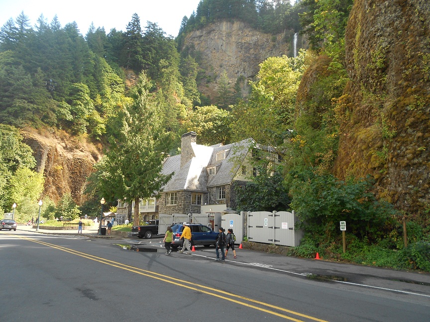
multnomah lodge
Multnomah Lodge
The Multnomah Falls, which plunges 620 feet in two sections, is one of the highly popular waterfalls along the route. It's said to be the most visited Oregon attraction.The 300 acres around the falls was donated by a prosperous lumberman, Simon Benson, in 1915 for the purpose of making the area a park. The Benson Bridge, a continuous pour concrete bridge named for Simon Benson, is a marvelous way to view the Multnomah Falls. It can be reached by a short paved trail from the Cascadian-style Multnomah Falls Lodge. In response to the heavy tourism traffic entering the area, the Multnomah Falls Lodge was built in 1925. The lodge was designed by Portland architect Alfred Doyle. Both the design, with two stone chimneys, and the exterior materials blend naturally with the surroundings.

Wahkeena Falls

Another beautiful and easily visited waterfall along the Columbia Scenic Highway is the 242 foot high Wahkeena Falls. Prior to 1915 and the building of the Columbia Highway, the falls were named Gordon Falls. Wahkeena Falls is located about one-half mile west of Multnomah falls. The base of the falls lie about 100 feet above the highway. The falls crash step by step down a narrow crack between basalt rock outcroppings. Many refer to this type of waterfall as a "tiered falls".

wahkeena falls oregon
Wahkeena Falls
The visitor here can also hike a short trail from the parking area a cross a rock bridge to get a better view. The falls can also be viewed from the highway. The translation of Wahkeena in the Yakama Indian language means "most beautiful". For those wanting to continuing climbing up the trail about a mile past Wahkeena Falls, two other falls will come into view, Necktie Falls and Fairy Falls. The trail to the falls begins at the commemorative monument at the parking area.

Wahkeena Falls Picnic Area is found at the base of the falls and features a picnic shelter with a stone fireplace.

Horsetail Falls

Horsetail Falls is a spectacular site that drops 175 feet down a mossy rock wall. Out of all the beautiful Columbia Gorge waterfalls, Horsetail Falls is the closest to the Columbia River Highway. It originates from the Horsetail Creek. The falls received it's name due to the fact that the water that goes over the rounded rock face resemble a horses tail. The falls has an elevation above the highway of about fifty feet.

horsetail falls in the columbia gorge
Horsetail Falls emptying into a pond
Horsetail Falls is located two and one-half miles east of Multnomah Falls. You also want to add a stop at Ainsworth State Park which is near both Horsetail Falls and the Cascade Locks. Ainsworth State Park is one mile east of Horsetail Falls. The park is named in honor of Captain J.C. Ainsworth, a pioneer Columbia River steamboat captain and one of the founders of the famous Oregon Steam Navigation Company. The Oregon Steam Navigation Company was founded in 1860 and eventually controlled steamboat operations over most of the vessels on both the Columbia and Snake Rivers.

The attractions shown in this article are only a small sample of what can be seen and enjoyed along the historic Columbia River Scenic Highway. The Columbia Gorge region between Troutdale and The Dalles is one of the most beautiful areas in the Pacific Northwest and is an excellent addition to any Oregon trip planner.

An excellent book on the subject of the Columbia Gorge is Bridge of the gods, mountains of fire : a return to the Columbia Gorge by author Chuck Williams. Another is Hiking the Columbia River Gorge by author Russ Schneider.

(Photos from author's private collection)


Tuesday, September 25, 2012

Fort Point / California


fort point california
Fort Point under Golden Gate Bridge
You're visiting San Francisco California and there's so many things to see and do. Cable cars, Fishermans Wharf, Nob Hill, China Town, the Presidio, Telegraph Hill, Union Square and a host of other sites can easily fill most vacation trip planners. Add in the many popular and historic sites in Marin County, the wine country in Sonoma and Napa Counties and in the East Bay cities and you've easily created a week's worth of stops.

You'll be wise to add Fort Point to your itinerary. Fort Point is one of the most unique historical sites the the United States. One of the reasons this particular fort is so unique has to do in where it's located. The site of Fort Point is directly under the south end of the Golden Gate Bridge and in the Golden Gate National Parks area.. Stand inside or outside the fort gate, look up and you'll see the bottom of the bridge. There's nothing else like it. Today, Fort Point is a National Historic Site administered by the National Park Service.

The Creation of Fort Point 

fort point national historic site
Interior of Fort Point
Fort Point of course was at the mouth of San Francisco Bay well before the Golden Gate Bridge. This fort represents the story of the beginnings of California as well as US Army history.

There may not have been a better positioned fort to protect the bay entrance. The Spaniards, the first Europeans to arrive in present day San Francisco, built the Presidio as well as fortifying the cliffs where Fort Point is now located. The Spaniards were concerned with encroachment from the north by both the Russians and the British. The Russians had reached all the way south to around present day Bodega Bay, about 60 miles north of San Francisco. As it turned out, the Russian colony were traders not colonizers and there was never an armed conflict between the two.

As far as California was concerned, and at one time it was called Alta California, the biggest event was the United States takeover from Mexican rule in 1846.That event was followed fairly quickly by the discovery of gold at Sutter's Mill and then the ensuing California Gold Rush. Things changed dramatically and it changed fast. Tens of thousands of people arrived in the area, most of them by sea.

cannons at fort point
Cannon on display at Fort Point
Fort Point was constructed between 1853 and 1861 as a base to protect the bay. The decision to build the fort came in 1850 when California became a state. At that time a series of fortifications were planned to protect the very important and busy bay. The work was done by some 200 workers, many unemployed miners. At it's completion, the U.S. was in a Civil War and the fort was manned to protect against any possible Confederate attack. Military officials stated that the fort's position and sophistication with large brick walls (seven feet thick) at the San Francisco Bay mouth was the key to the whole Pacific coast.

As it turned out, the guns at Fort Point would never fire a shot during the war. According to information published by the National Park Service, there actually was a Confederate vessel, the CSS Shenandoah that did plan to attack San Francisco but on it's way learned that the war had ended. When the Civil War ended in 1865 the fort was garrisoned as a general army defense position as well as a barracks site.

fort point lighthouse
Lighthouse at Fort Point under Golden Gate Bridge
Another interesting fact according to the National Park Service was that the fort was actually renamed Fort Winfield Scott in 1882 but for whatever reason the name didn't stick. Eventually the name Winfield Scott was placed on an artillery post at the nearby Presidio. Winfield Scott was a national hero of the Mexican American War.

Two additional related Western Trips articles and photos you'll find interesting are the Sonoma California Mexican Barracks and Mission and also Sutter's Fort and New Helvetia.

Key Changes in 1892

As the years went by, many technological weapon changes took place. In 1892, the army started to construct new concrete and steel fortifications that would contain breech loading rifled guns. The era of the cannon was coming to an end. The 1906 Earthquake was obviously devastating to San Francisco and the fort wasn't entirely spared. Fortunately it was only moderately damaged. After the earthquake, Fort Point was mostly used for training and for barracks space although the members of the 6th Artillery Coast Guard were stationed there during World War two.

powder keg at fort point national historic site
Fort Point powder keg exhibit
Saving Fort Point

As happens occasionally with historic sites, their cultural importance sometimes conflicts with modernization. In the case of Fort Point it involved the planned Golden Gate Bridge. The actual plans for the bridge called for the removal of Fort Point. When you visit the fort, you'll see just how close the bridge structure is to the fort. Lucky for all of us the final plans for the bridge worked around the fort. You can see the changes in the Golden Gate Bridge construction and how it accommodated Fort Point.

The future of Fort Point was solidified when President Richard Nixon, in 1970, signed a bill officially making Fort Point a National Historic Site.

Directions to Fort Point

Fort Point is located at the end of Marine Drive on the Presidio of San Francisco. Getting there can be a bit tricky. If you're coming from San Francisco proper or points south of the Golden Gate Bridge, take Highway 101 north and exit right at the Golden Gate Bridge toll plaza but before getting on bridge. Turn right at end of exit ramp and then left onto Lincoln Boulevard. Take the first left onto Long Avenue and follow onto Marine Drive and Fort Point at its end. There is parking available before getting to the fort itself.

When you enter the fort you'll see a large brick fortification with several different replica models of cannon. Some of these are Spanish cannons. The fort has an extensive artifact collection including the powder storage room. It's quite an impressive display. You can also walk to the top of the fort and get a great view of the narrow opening between San Francisco Bay and the Pacific Ocean. Also a great place to get some unique Golden Gate pictures.

An excellent book regarding historic Fort Point is Fort Point: Sentry at the Golden Gate by author John Arturo Martini.

(Photos from author's private collection)


View Larger Map

Saturday, September 22, 2012

Officers Row / History of Fort Vancouver

officers row at fort vancouver
Ulysses S. Grant House on Officers Row
Our western road trip takes us to the beautiful American Northwest. The area of Oregon and Washington states is unsurpassed in it's natural beauty. If you have the opportunity to visit this part of the country whether on a vacation or for other purposes, you won't be disappointed. If you're also looking for historic sites, this is where you want to plan your American Northwest vacation. After all, it was this part of the country where the earliest of pioneer settlers journeyed to. The official end of the great Oregon Trail is found at Oregon City, just a few miles south of Portland. A mixture of great scenery and great history.

Officers Row

Straight across the Columbia River from Portland Oregon is Vancouver Washington. One of the popular sites at the old Fort Vancouver is "Officers Row". Officers Row is found on the northern boundary of Fort Vancouver. Officers Row consists of twenty-two restored nineteenth century homes. These homes cover an area of twenty-one acres just north of the Vancouver Barracks Parade Grounds and the Visitors Center. The homes are located on Officers Row street. These are beautiful homes and several are open to the public for tours. These include the Marshall House and Ulysses S. Grant House. We were fortunate to tour both. The Grant House has a very fine restaurant and is open for breakfast, lunch and dinner. Patio dining is available weather permitting.

general george c marshall house
General George C. Marshall House
Fort Vancouver and the Hudson's Bay Company

The history of Fort Vancouver dates back to 1814 and the Hudson's Bay Company. Although the U.S. took possession of the region in 1846, the Hudson's Bay Company didn't officially leave the area until about 1860. The Hudson's Bay Company traded with the local Indians. The Hudson's Bay Company traded with goods sent to them directly from Britain. An interesting fact, according to historic information published by the National Park Service, was that when an order for goods to trade was sent to Britain, it could take up to two years for the order to be filled. Almost inconceivable when you consider that today's media mail takes about ten days. During the early 1800's all communications went by sea and that meant months. In those days there was no Panama Canal. Ships between the American west coast and Britain would travel either via Cape Horn or across the Pacific to the Indian Ocean and then on to the Atlantic Ocean.

Two additional Western Trips articles and photos you'll want to see are Historic Oregon City and Astoria Oregon, the old Pacific Fur Company fort at the mouth of the Columbia River.

general o o howard house at fort vancouver
General O.O. Howard House
The Many Names of Fort Vancouver

The United States Army eventually took over the fort and renamed it Columbia Barracks in 1849. In 1853 it was renamed Fort Vancouver and in 1879 was renamed again, this time to Vancouver Barracks. It also was referred to at one time as Camp Vancouver. It site remained an important military base for many years and it was said that a stint of duty at Vancouver Barracks was very good for one's military career. The homes on officers row were built in the 1800's. The Ulysses S. Grant House was built in 1849. Grant served as quartermaster at the fort from 1852 to 1853 and of course went on to become a U.S. President. The General George C. Marshall House was constructed in 1886. The general and his wife occupied the home from 1936 to 1938. Marshall served as Chief of Staff for the Army during World War Two.

Another interesting house is the General O.O. Howard House. The house was built in 1878 and was once considered the finest house north of the Columbia River. The house today is the headquarters of Fort Vancouver National Trust.General Howard was at one time the commander of the army's Department of the Columbia based at Vancouver.  He was also the founder of Howard University.

marshall house interior on officers row
Marshall House interior
Vancouver Barracks was the very first U.S. Army post in the Pacific Northwest. The base was important as a supply depot during the Civil War and also as a command headquarters during the Indian War years. Vancouver Barracks also went on to play a role during both World War One and World War Two.

During the First World War the base was the headquarters for the Army's Signal Corps' Spruce Production Unit. In 1925, the army constructed Pearson Field which gave it an early role in military aviation. You'll see Pearson Field along the south side of the Historic Site. Today, Pearson Field has the distinction of being the oldest operating airfield in the United States. During the 1930's, Vancouver Barracks was a district headquarters for the Civilian Conservation Corps. During the Second World War, Vancouver Barracks served as a training center and staging area for the Portland Subport of Embarkation.


Visit Officers Row

Officers Row is both a very historic place and today is also the home of area businesses. Several of the homes are leased to businesses. When you enter the 366 acre Fort Vancouver Historic Site you want to begin your tour at the Visitors Center. From there you can obtain a tour map of the entire fort area including the restored stockade fort south of Officers Row. The tour can be a walking experience or you can drive to several of the sites shown on the tour map. Ample parking is available. The Visitor Center address is 1501 E. Evergreen Blvd., Vancouver, WA.

(Photos are from author's private collection)
View Larger Map

Thursday, September 20, 2012

Best Vineyards in Sonoma


Francis Ford Coppola Winery
Francis Ford Coppola Winery, Geyserville, CA
Among the best vineyards in Sonoma that you do want to add to your wine country trip planner are the Francis Ford Coppola Winery in the Alexander Valley region of Sonoma County and the B.R. Cohn Winery & Olive Oil Company on the Sonoma Highway in Glen Ellen California.

Two additional Western Trips Sonoma County articles and photos you'll find interesting are the historic Buena Vista Winery, the oldest winery in Sonoma County and the Luther Burbank Home and Gardens located in Santa Rosa California.

Francis Ford Coppola Winery / Geyserville California

The Francis Ford Coppola Winery is located at 300 Via Archimedes in Geyserville, CA, just west of US Hwy 101. This is absolutely one of the most unique wineries in Sonoma County. First of all, this is the only winery in Northern California that offers a swimming pool. This is no ordinary pool. It's 3,600 square feet in size. When you arrive at the winery and stroll through the front gate, you'll see a swimming pool that will remind you of some of the finest resorts you've ever visited. There's an outside bar adjacent to the pool and changing rooms for those who have checked in near the front entrance. 

coppola winery swimming pool
Coppola Winery Swimming Pool
Daily pool passes are available. In addition to the pool which is available to visitors, you'll be able to enjoy a fine dining experience either inside or on the large patio overlooking the vineyards. Sandwiches, personal pizza and a great list of appetizers are offered. Beverages available include Coppola Wines, cocktails and beer. During our visits to the winery we have always been able to enjoy the outside patio for dining and I would definitely recommend it, weather permitting which it usually does. The scenery viewed from the patio makes it a great experience.

Francis Ford Coppola purchased the former Chateau Souverain winery in 2006. The idea was to create something very different in Sonoma County. The idea for the Coppola Winery had it's roots in the Tivoli Gardens in Copenhagen. The winery and it's surroundings is really something for the entire family to enjoy.The Coppola Visitor Center is a two story building reached by a grand staircase from the parking area. Inside is the restaurant with it's patio, a wine tasting room and bar along with a gift shop.

francis ford coppola winery staircase
Grand staircase at Coppola Winery entrance
Another special attraction at the Francis Ford Coppola Winery is a vintage car exhibit indoors. Exhibited is a very rare Tucker automobile from the 1940's. The Tucker is noted for it's sleek design, especially during the mid 1940's, and for it's three headlights. One reason the Tucker car is so rare is that there were only some fifty-seven ever built. The Tucker car exhibit at Coppola Winery is a rare treat in itself and classic car enthusiasts will enjoy visiting this truly unique Sonoma County winery. 

A visit to the Coppola Winery is an all around good time.

You will find an interesting article and photos about the Tucker car on our AutoMuseumOnline.com website.

The B.R. Cohn Winery and Olive Oil Company

This Sonoma County winery was established in 1984 by Bruce Cohn. The B.R. Cohn Winery features a full line of ultra-premium wines, extra virgin olive oils, handcrafted vinegars and a great selection gourmet food products.
b r cohn winery
The B.R. Cohn Winery
Like many wineries in Sonoma County, the B.R. Cohn Winery and Olive Oil Company schedules several events during the year which are a real treat for visitors. These include the B.R. Cohn Charity Fall Music Festival, a celebrity golf tournament and classic car shows. Like many California wineries, the B.R. Cohn Winery hosts weddings and other events. 

Bruce Cohn is known to also be a classic car collector who sponsors the B.R. Cohn Charity Car Classic held annually. This very successful  event helps raise money for Redwood Empire Food Bank of Santa Rosa. You'll be assured to view some extremely well restored vintage automobile and trucks at this charity car show. The winery also hosts Classic Car Cruise-Ins.  These are generally held on Sundays May to October. Classic car owners are encouraged to attend and bring their cars. Admission is free.

b r cohn winery grounds
B.R. Cohn Winery grounds
Bruce Cohn is the long time manager of "The Doobie Brothers" California rock band. The Doobie Brothers have also performed during the wineries annual concert series. The B.R. Cohn Winery is known as a great venue where excellent wine blends with excellent music. Good wine and good music always go together in California. 

Bruce Cohn grew up on a dairy farm in the Russian River area of Sonoma County. The original 46 acre site purchased in 1974 has doubled in size. The property also consisted of 145 year old Picholine Olive trees. It was named the Olive Hill Estate Vineyard and produced world class olive oil. The olive trees are used today to make the ultra-premium olive oil sold at the winery today. After spending time selling grapes to local wineries and getting some expert advice, the property was turned into a winery itself in 1984. The olive trees are used today to make the ultra-premium olive oil sold at the winery today. Along with the award winning olive oils you'll find excellent hand made vinegars. 

(Article and photos copyright Western Trips)


SONOMA VINEYARDS VIDEO


Tuesday, September 18, 2012

Astoria Oregon

National Geographic 603070 821 Boots Columbia River Gorge Oregon (Google Affiliate Ad)
columbia river ships
Ship on the Columbia River off Astoria

 Things to Do in Astoria Oregon

Astoria Oregon, located in the northwestern corner of Oregon at the mouth of the Columbia River, offers the western tourist plenty of things to do and many sites to explore. Make a note of great attractions such as the Columbia River Maritime Museum, Fort Stevens and Fort Clatsop. The Columbia River Maritime Museum is one of the finest museums in the United States and is filled with many authentic boat exhibits, some interactive, artifacts, photos and everything that details maritime history of the Pacific Northwest and the Columbia River.

How Astoria Came into Being

Astoria Oregon first came into being by the efforts of John Jacob Astor to establish a base for his new Pacific Fur Company. This was a pretty aggressive move since Astor would be challenging the Hudson's Bay Company along with the North West Company. Astor actually sent out two different expeditions to locate a satisfactory trading post. One was sent overland beginning from Montreal. The other expedition set out by sea, rounding Cape Horn and sailing all the way up the South American and North American coastlines to the mouth of the Columbia River. This all occurred in 1811-1812, just five years after the famous Lewis and Clark Expedition which also ended at the mouth of the Columbia. The overland party reached the mouth of the Columbia River in February of 1812 and the seafarers about a month later.

columbia river maritime museum
Columbia River Maritime Museum
The members of the expedition met with some local Indian hostility and suffered some fatalities but the site chosen was eventually cleared of timber and a fort/trading post was erected. The most significant loss of life occurred when the ship that arrived from the Cape Horn route, Tonquin, sailed north along the coast to trade with Indians. This trading expedition met with disaster when the party was massacred by Indians they were trading with.

Relations With Local Indians

In the book, It Happened in Oregon, author James A. Crutchfield describes how the party back at Astoria managed to keep the Indians around their fort under control after hearing about the Tonquin tragedy. One of the expedition leaders, Duncan McDougal, who also feared that his group might be attacked by the Indians around Astoria, devised a plan. McDougal gathered together the leaders of local tribes. At this gathering he showed them a bottle he was carrying and said to them " The white men around you are few in number, it is true, but they are mighty in medicine. See here, in this bottle I hold the smallpox, safely corked up. I have but to draw the cork, and let loose the pestilence, to sweep man, woman and child from the face of the earth". This startled the Indians. They greatly feared an epidemic and as a result swore peace with the settlers. Shortly afterward, the expedition resumed trading with the Indians.

columbia river logging industry
Logging industry along the Columbia River
Big Changes at Astoria

In regards to Astor's plans for his new fur company, by late 1813, the British owned North West Company took over Astoria including all of it's furs and furnishings after purchasing everything from Astor. This occurred after an Astor supply ship was late in arriving and because of the settlements vastly undermanned situation due to the Tonquin massacre. Interestingly enough, even though the fort was now owned by a British company, the British military took over the fort in 1814 and renamed it Fort George. The North West Company shortly thereafter continued it's fur operations from the fort. The British military aggressiveness in the region was an extension of the then War of 1812.

Eventually, in 1821, the North West Company merged with the Hudson's Bay Company. The Hudson's Bay Company wasn't satisfied with the location and constructed Fort Vancouver across the Columbia River from present day Portland Oregon. Fort Vancouver would go on to be the chief site of operations for the Hudson's Bay Company and eventually for the U.S. military..

astoria oregon
Astoria Oregon
The major change in the American Northwest occurred in 1846 when the United States and Great Britain divided up the entire region. What the U.S. would obtain from this division is now the states of Oregon, Washington, Idaho and parts of Wyoming and Montana. Oregon's northern border with Washington was determined as being the Columbia River. Oregon would go on to become the official Oregon Territory in 1848 and eventually attained statehood status in 1859 as the nation's thirty-third state.

Today, Astoria Oregon is both a busy port as well as a very popular tourist destination. It's location at the mouth of the Columbia River on the Pacific coast makes it a very scenic area. Astoria Oregon lodging is plentiful and you'll find an excellent selection of restaurants.

clatsop county heritage museum
Clatsop County Heritage Museum
 In addition to the Columbia River Maritime Museum mentioned above, the area is also home to the Lewis and Clark National and State Historical Parks, Fort Stevens State Park to the west on the ocean, the Astoria Riverfront Trolley, Fort Clatsop National Memorial, the Flavel House Museum, the Clatsop County Heritage Museum which is housed in the old City Hall building constructed in 1904 and pictured at right and several other historical attractions. You'll find many fun things to do in Astoria.

Two additional Western Trips articles that you'll find interesting are Historic Oregon City and the story of Fort Kearney Nebraska, the key fort for immigrants along the old Overland Trail.

When you drive south from the Astoria area on US Hwy 101, tourists enjoy several of the beachfront towns such as Seaside and Cannon Beach Oregon, twenty-five miles south of Astoria. It's estimated that these two coastal towns receive about 750,000 tourists annually. The beaches are excellent and there's a large number of beach rentals and B & B's available as well as a great selection of restaurants.

(Photos from author's private collection)
View Larger Map

Sunday, September 16, 2012

Oregon City

columbia river
View of Columbia River east of Portland Oregon

If your plans for a western trip call for a visit to the American Northwest, Oregon is a must destination. The state of Oregon and historic Oregon City, just a few miles south of Portland, tell much of the story of westward immigration during the middle part of the 1800's. The history found there and the unsurpassed beautiful scenery make Oregon an excellent vacation destination. Between the beautiful Columbia River Gorge just east of Portland, to the fertile Willamette Valley, Willamette River, Mount Hood and the mountainous coastline, Oregon can either be a part of you vacation or the entire thing.

The first United States citizens to arrive overland in present day Oregon were among the Lewis and Clark  Expedition of 1804-1805. This was followed in 1810 by the Astor Expedition which sought to establish a fur trading operation in the area. Fort Astoria was established at the mouth of the Columbia River at the site of today's Astoria Oregon.

A 2,000 Mile Route

The city of Oregon City itself is both historic and scenic. Located along the Willamette River, Oregon City was the final destination for most of the Oregon Trail immigrants. If you're looking for the end of the Oregon Trail, it can be found at Oregon City, Oregon.

willamette falls
Willamette Falls
The Oregon Trail was composed of a series of very old Indian trails and in some cases animal trails. These trails or paths were first used by white fur trappers and traders. The trail ran west from Independence Missouri through Nebraska and Wyoming. In western Wyoming near Fort Bridger, the trail parted. Those seeking to reach Oregon traveled northwestward along the Snake River and then down the Columbia River and finally up the Willamette River. Those heading to California would take a southwestward route over Utah and Nevada and eventually Donner Pass in the Sierra Nevada. Some travel was by river and at times around the many mountains and hills in the region. It was a treacherous 2,000 mile journey. The dangers present were not only from hostile Indians and possible starvation but also from sickness, in most cases cholera and smallpox. After a steady rise, immigration to Oregon peaked in 1852.

The Founding of Oregon City

The entire area of present day Oregon and Washington state was at one time inhabited by workers for the Hudson's Bay Company. This was long before the Oregon Trail days. Their main base of operation was at Fort Vancouver, just across the Columbia River from present day Portland Oregon. In 1829, the Chief Factor at Fort Vancouver, Dr. John McLoughlin, planned a two square mile settlement at Willamette Falls on the Willamette River. He had three houses built which were burned down in short order by local Indians. McLoughlin was not deterred and had the houses rebuilt. From there the settlement grew with a mill being constructed using the Willamette Falls as a power source. These were the first buildings of a white settlement in Oregon. Most of the inhabitants were workers for the Hudson's Bay Company. At the time, the settlement was called Willamette Falls.

mclaughlin house in oregon city
McLaughlin House
Willamette Mission

In 1834, the Reverend Jason Lee and his nephew, Reverend Daniel Lee, were approved by the Mission Society of the Methodist Episcopal Church to establish a mission in the west. When the Lees arrived at Fort Vancouver, Dr. McLoughlin encouraged them to start their work south of the Columbia River in the Willamette Valley. The Willamette Mission was established in 1834 in present-day Marion County.

A key event occurred in 1839 when Reverend Jason Lee traveled to Illinois for a series of lectures. Reverend Lee was looking for recruits for the Willamette Mission as well as settlers to Oregon in general. His travels were met with success. The country was going through a financial depression at the time therefore there were many looking for a fresh start. This was the beginning of the Oregon Trail days.

The First Settlers

Heeding the call of Reverend Lee, the first settlers arrived in the Willamette Valley in late 1839 and early 1840. Each year thereafter, immigration to Oregon increased. Oregon City was the destination of most. From there they could obtain parcels of land and begin their homesteads. The early settlers in the 1840's called the falls,"Hyas Tyee Tumwater" which is generally translated into "Great Chief Falls". This was the name given by the Clackamas Native Indians of the area. Today there is a dam and locks at the falls including a fish ladder. The Indians eventually relocated to Grande Ronde Reservation by the 1850's with a few groups remaining in Clackamas County. It's estimated that about 53,000 settlers arrived in Oregon between 1841 and 1860.

oregon city municipal elevator
Oregon City Municipal Elevator
Creation of America's Northwest

Ever since the end of the 1700's, the Pacific Northwest was a contested area between Great Britain and the United States. Great Britain's presence in the area was largely through the Hudson's Bay Company. In 1846, the United States and Great Britain finally divided the land of the Northwest. The U.S. obtained what is today Oregon, Washington, Idaho and parts of Montana and Wyoming. Territorial status for Oregon would not happen until 1848 and not until a tragedy sped up the process. In November of 1847, the Whitman Mission near Walla Walla Washington was attacked by Indians. Both Mr. and Mrs.Whitman and several others were killed. Some 50 plus including women and children were kidnapped. This tragedy so shocked the U.S. Congress that the region was divided into Territories and Oregon received territorial status in 1848.

oregon city view
Oregon City from atop the bluff
Things To Do In Oregon City

The Willamette Falls- The Willamette Falls is the largest waterfall in the Pacific Northwest and only second to Niagara Falls in volume.

The Oregon State Welcome Center and Official End of the Oregon Trail- 1726 Washington Street.

McLaughlin House- 713 Center Street.

Two additional Western Trips articles and photos you'll enjoy are a trip on the Amtrak Coast Starlight and the Oregon Trail wagon ruts at Lake Guernsey State Park in Wyoming.

The Museum of the Oregon Territory- 211 Tumwater Drive.

The Oregon City Municipal Elevator- A very unique must stop on any visit to Oregon City.Most of the town during the early years was located along the river. When the city grew, there was a need to find an easier way to get up the ridge line to the east. In 1867, steps were built to help one get up the bluff. An elevator made of steel and wood was put into operation in 1915 powered by water pressure. In 1924, the power source was changed to electricity. The existing elevator was built in 1955. This is one of just four municipal elevators in the world. After ascending the bluff you'll have a terrific view of Oregon City, the Willamette River and the Willamette Falls.

This is a spectacular part of Oregon and filled with history.

(Photos from author's private collection)


Friday, September 14, 2012

Amtrak's Coast Starlight

When you're planning a western trip or an extended vacation, here is an opportunity to see the west coast of the U.S. in a very unique and fun way. This is also a way to enjoy a relaxing vacation without the traffic hassles. See the California, Oregon and Washington state scenery while enjoying the views from a comfortable chair. It's a vacation that truly gives you the opportunity to unwind.

Out of all the Amtrak routes spread across the United States, the train name that many refer to as Amtrak's signature train is the "Coast Starlight". The Coast Starlight operates daily service between Los Angeles California and Seattle Washington in both directions.

mount shasta california
Mount Shasta from Coast Starlight
Here is a route that runs through some of the most beautiful scenery found anywhere in the country. A blending of the picturesque California coast with the towering green mountains of the Pacific northwest. Amtrak's Coast Starlight service might be the most popular of it's routes and with a very good on time record. The other train which Amtrak operates along the California coast is the Pacific Surfliner. This route goes from San Diego up to Santa Barbara. The Pacific Surfliner daily schedule is as follows. The train departs Santa Barbara at 6:43 AM and arrives in Old Town San Diego at 12:17 PM. The northbound daily segment leaves San Diego Old Town at 9:30 AM and arrives Santa Barbara at 3 PM.

klammath falls oregon
Klammath Falls Oregon Amtrak Station
The total scheduled time for the entire trip between Los Angeles and Seattle is about 35 hours and the total mileage is 1,377. It should be noted that the Amtrak Coast Starlight is the very first train that ran the entire west coast route from L.A. to Seattle. Prior to the Coast Starlight, the route up to Seattle was handled by the Southern Pacific Railroad via the inland San Joaquin Valley to Portland and then to Seattle via the Great Northern Railway.At the same time, the Southern Pacific ran sleeper car service between Los Angeles and San Francisco. It wasn't until the start of Amtrak in 1971 that the entire Los Angeles to Seattle route was serviced with one named train.

Amtrak's Coast Starlight also offers something very unique, not found on any of it's other routes. This is the Pacific Parlour Car. The Pacific Parlour Car are  restored and refurbished two deck rail cars once owned by the Atchison Topeka and Santa Fe Railroad. These rail cars were built in 1956 for ATSF's "El Capitan" service. The Parlour Car was first put into service on the Coast Starlight in 1995 on an experimental basis and became so popular and actually raised ridership that it became a permanent part of this particular Amtrak route.

amtrak coast starlight
Coast Starlight at one of it's stops
The upper level of the Parlour Car contains both four person booths and a lounge area with both sofa seating and eight upholstered parlor chairs. The upper level seats a total of forty people plus some standing room at the bar. The lower levels is a nineteen seat movie theater. Again, these highly popular Parlour Cars are found only on the Coast Starlight trains and are available for use by sleeper car passengers only.

The Amtrak Coast Starlight departs Los Angeles' Union Station at 10:25 AM each morning and is scheduled to arrive in Seattle Washington the next day at 8:45 PM.

The scenery along the Coast Starlight route is some of the best found anywhere in the country. The high snow covered peaks of Mount Shasta and the Cascade Range, thick green forests, fertile valleys and long portions of the Pacific Ocean shoreline set this route apart from all others. The route follows about 100 miles of the Pacific shoreline and is the longest ocean view train ride in the U.S.

upper klammath lake
Upper Klammath Lake Oregon
The Coast Starlight connects some of the greatest cities on the west coast. For those riding the Coast Starlight, the route and schedule lets you enjoy the trip up the California coast with daylight stops in such paces as Santa Barbara, San Luis Obispo and Salinas. The train reaches Oakland's Jack London Square about 9:40PM. Daylight next occurs in far northern California just south of the Oregon border. The daylight hours then lets you enjoy such stops in Oregon as Klammath Falls, Eugene, Salem and Portland. Popular sights along that portion include Upper Klammath Lake and the Cascade Mountains as the Amtrak route goes up and over that beautiful range.

After a stop in Portland Oregon, Amtrak's Coast Starlight continues north crossing the historic and very scenic Columbia River. Stops on the way to Seattle include Vancouver Washington, Longview, Olympia and Tacoma. The train's schedules arrival in Seattle is 8:45PM. Amtrak thruway bus service is available from Seattle to Vancouver British Columbia.

cascade mountains
Beautiful lake in the Cascade Range
The Amtrak Coast Starlight offers three meals per day served in the dining car. The food served is quite good and are included in the room charge for those passengers riding in the bedrooms and roomettes of the sleeper cars. Coach passengers can purchase meals and beverages in addition to their fare. The Coast Starlight had a reputation for running late on a somewhat regular basis. The late running Coast Starlight suffered passenger ridership declines as a result. The Union Pacific Railroad handles all traffic on this route and received a lot of the blame by railroad enthusiasts. They accused the Union Pacific of putting priority on their freight trains and the railroad answered that delays were attributed to track repair projects. Whatever the problem was, that situation fortunately has changed and the Union Pacific has given priority to the passenger trains. As an example of the improvement, the Amtrak Coast Starlight reported an 86 percent on time rate in 2008. The trip in 2012 that I took arrived in Oakland about 20 minutes late but arrived in Portland Oregon about 5 minutes early. Anyone familiar with train travel would agree that this would be considered as running on time.

 Here are links to two additional articles with photos you'll enjoy.  On our Trips Into History site is the Amtrak Southwest Chief and on Western Trips, the famous old Atchison Topeka and Santa Fe Railroad's Super Chief.

I would highly recommend the Amtrak Coast Starlight to anyone looking for a different and fun way to experience the west coast of the U.S. It's the perfect western trip to unwind, meet people and simply enjoy scenic travel without hassles.


(Photos are from author's private collection)

Tuesday, September 11, 2012

UH-1 / California Air Museum

When traveling in Sonoma County California, the Pacific Coast Air Museum , PCAM, is an excellent venue for a trip back into history. The museum located at the Charles Schulz Sonoma County Airport just a few miles northwest of Santa Rosa California is a treasure. In addition to having on display the authentic First Responder F-15 military jet that was airborne over New York City on September 11, 2001, there is a marvelous collection of military aircraft of all types.

The UH-1 Helicopter

pacific coast air museum
Pacific Coast Air Museum
One interesting exhibit is the UH-1 "Huey" helicopter. This aircraft was the first turbined powered helicopter used by the U.S. military and the Vietnam War was the first time the craft was used in combat situations. Some seven-thousand of these aircraft served during the Vietnam War. During that period about 3,300 were destroyed. They were manufactured by Bell Helicopter.

The UH-1H Huey on display at the Pacific Coast Air Museum was restored and updated and displays markings of the 188th Assault Helicopter Company referred to as the "Black Widows". This particular helicopter saw combat action in Vietnam flown by "Black Widow" air crews. When the Pacific Coast Air Museum acquired this helicopter it was being used by the California National Guard. The restoration was performed by Vietnam Vets from the Black Widow unit. Other markings seen on this aircraft include the bulls-eye of the 269th Combat Aviation Battalion, white markings belonging to the 2nd Platoon and the 2nd Platoon's "Lucy in the Sky with Diamonds" door marking.

uh-1 helicopter
UH-1H Huey at PCAM
Specs for the UH-1H include five separate fuel tanks. The fuel tanks did not have armor but were self-sealing. The armor was available for the pilots seats. Cabin capacity was generally two seats for the pilots and up to thirteen for the troops.

The cabin area could also be utilized for six stretchers instead of the full compliment of soldiers. Seats were constructed of aluminum tubing with canvas. The cockpit area had dual controls which were operated hydraulically.

The UH-1H Huey Iroquois, thought by many to be the most famous helicopter in the world, as shown here has a Lycoming T-53L 1,400 HP engine with a top speed of 138 MPH and a ceiling of 13,600 feet. The range is 360 miles. First flights were made in 1956 with the U.S. Army adopting the helicopter in 1958.The term "Huey" was added as a nickname.

During the many years of the war, the Huey was modified and updated. The most significant change was a longer fuselage. The Bell 204 models were replaced with the longer 205's.

uh-1 huey helicopter
UH-1H Huey Helicopter markings
The UH-1's lasted until they were replaced as a first line helicopter by the UH-60 Black Hawk. There are still a few hundred that the army has kept in service.

To give you some perspective between the Huey and the Sikorsky UH-60 Black Hawk, the Black Hawk has twin turbo-shaft engines delivering a top speed of about 200 to 220 MPH with a combat radius of about 360 miles and a ferrying range of 1,380 miles. The main rotor is four bladed and the craft has a single tail wheel. Just as was the case with the Hueys, the Black Hawk has several modified and upgraded models flying. It's weapons include several different caliber machine guns including anti-tank missile launchers. The Black Hawk helicopter first saw combat in 1983 in Grenada.

During the Vietnam War, the Huey was used for a vast array of purposes. This included ferrying troops into battle, medical evacuation, ground assault, observation, electronic warfare and search and rescue.

You will also be interested in our Western Trips article and photos of the F-15 First Responder jet and the Grumman S2-A Tracker on display at the Pacific Coast Air Museum. Also, our article and photos of the Beech 18 at the Western Antique Aeroplane and Automobile Museum.

A visit to the Pacific Coast Air Museum is a great addition to a Sonoma Wine Country vacation or weekend visit. The museum, founded in 1989, this non-profit organization has done an excellent job of restoring vintage military aircraft and has a wide photo and artifact collection as well. It's well worth adding to your Sonoma County California trip planner. The museum is located at 2230 Becker Boulevard, Santa Rosa, CA at the Charles Schulz Sonoma County Airport.

(Photos from author's private collection)


View Larger Map

Sunday, September 9, 2012

Historic Richmond California Ford Plant


History buffs of World War Two military production will enjoy a fun visit to the old Ford Motor Company assembly plant in Richmond California. Richmond is just northeast across the bay from San Francisco. This old Ford factory has been excellently preserved at the Point Richmond. This Ford plant, designed by Detroit architect Albert Kahn, produced some 49,000 jeeps and 91,000 additional military vehicles to aid America's war effort. Albert Kahn was noted for his "daylight factory" design which meant many windows. The factory measured 500,000 square feet. The building of the Ford plant in Richmond was part of the 1930's plan for having assembly plants spread throughout the country. While architects like Albert Kahn designed the outer look of the plant, Ford Motor Company's internal production designers planned the layout of the assembly equipment.

ford motor company richmond california
Old Ford Motor Richmond CA plant
When the plant was built in 1930, the plan was to produce about 400 vehicles in an eight hour work shift. Total employment at the assembly plant was planned for 2,600. Ford Motor Company, as a rule, always insisted that their building contractors have an open shop where union and non-union workers would be hired.

During the 1930's, the Ford Richmond plant was the third largest employer in the area. The first two were the Standard Oil Company and the Santa Fe Railroad. The Kaiser Shipyards hit peak employment during the war years. 


 Ford Richmond Plant During World War II


During World War Two, the entire area of Port Richmond was a production zone. The Kaiser Shipyards were located there along with the Ford Motor facility. This was one of the shipyards that turned out the famous "Liberty Ships" that at first, due to a contest among various shipyards, were built in an astonishing five days due to prefabrication of components. Still, when the ships were constructed by conventional means, they could be built in about two weeks. That also is amazingly fast. This kind of production as well as that going on at the Ford factory caused the population of Richmond California to explode during the war years. The Kaiser Shipyard number 2 at Richmond was considered the busiest of all the shipyards producing 747 ships. The Rosie the Riveter images seen during the war commemorated the women dressed in overalls and using industrial tools to help America's war effort. This poster was widely publicized in newspapers and magazines during the early 1940's. During the peak of war production, women accounted for 27 percent of the total Kaiser Shipyard workforce of 93,000.


ford motor company war plant
Richmond CA Ford war plant
As far as automakers were concerned, during World War Two, President Roosevelt banned the production of civilian vehicles. The Ford Richmond factory switched over to producing military jeeps and finishing tanks built elsewhere. The plant even picked up the nickname as the "Richmond Tank Depot".

Ford did a lot of work putting armor on the tanks and other vehicles destined for the Pacific War Theater. Many say that the combination of private and federal cooperation as evidenced at Point Richmond during the war were the beginnings of what would eventually be called the Cold War Military-Industrial Complex. During the war, the government and private industry, at least with heavy manufacturing, seemingly worked as one entity.

When the war ended, the effect on the local economy of Richmond was quite serious. This was started with the closure of the Kaiser Shipyard and was further aggravated when the Ford plant eventually closed down. While the Ford Richmond plant continued on with civilian auto production after the war to make up for the pent up demand for cars, the last Ford car built at this plant was in 1953 and the Ford plant closed for good in 1956. Assembly was ultimately sent to the plant which is now the San Jose Ford Assembly factory. Today, this historic landmark is part of the Rosie the Riveter / World War II Home Front National Historical Park.


rosie the riveter poster in richmond ford plant
Rosie the Riveter poster in old Ford factory
The preservation of these historic sites in Richmond is a great victory for historic preservationists. Richmond California war production was so large that it was the natural location for a park commemorating this wartime work. While the park is owned by the City of Richmond, the park is administered by the National Park Service.

Next to the old Ford plant is the Park Museum which is probably one of the finest pertaining to west coast war production. The exhibits there are really one of a kind. Just about every facet of the work done at this location and the people involved in it is presented at the park museum.

Historic Ships

Another very interesting attraction at Point Richmond is the SS Red Oak Victory Ship. Here you can tour the entire ship including the bridge and see more historic artifacts and photos. The SS Red Oak Victory Ship was built right there at the Kaiser Shipyards and saw service as late as the Vietnam War. Between the Ford Plant exhibit , the museum and the Victory Ship, visiting the park makes a great family outing.

Two additional articles with photos on Western Trips you'll find interesting are the USS Pampanito World War Two submarine on permanent display at San Francisco's Fishermans Wharf and the SS Red Oak Victory Ship on permanent display at Point Richmond California.

rosie the riveter richmond california park museum
Rosie the Riveter Park Museum
Rosie the Riveter / World War II Home Front National Historical Park came into being on May 26, 2012 with it's grand opening. The goal of this new historic park, whose idea actually began back in 1998, is to honor the efforts and sacrifices of the American civilians who worked on the home front.

Many interesting personal stories and perspectives are showcased and I think any visitor will find these particularly interesting. The museum will surprise you as to the authentic exhibits displayed. When visiting or vacationing in the San Francisco Bay Area, the park is easy to reach from either side of the bay via Interstate 580 which connects Richmond to San Rafael. The park Visitor Center is located at 1414 Harbour Way South, Suite 3000. Richmond, CA.  

(Article and photos copyright Western Trips)