

In the western U.S. there are several very interesting sites where settlers, soldiers and other travelers left their mark for future generations. Independence Rock Wyoming and Pompey's Pillar in Idaho are two of them. Another interesting and quite scenic site that Western Trips had the opportunity to visit is Inscription Rock at the El Morro National Monument in New Mexico. This site is located on NM 53 between the towns of Grants and Ramah.
 |
| El Morro National Monument |
Inscription Rock, located about 125 miles west of Albuquerque New Mexico, is a 200 foot sandstone bluff where the bottom contains seven centuries of human inscriptions. Today's visitor to Inscription Rock has a choice of two trails to hike. The first is a relatively short trail which is about one-half mile each way. If you have only about an hour to visit El Morro, this is the trail to take. The second is about two miles long. Either of these trails will take you to the base of the rock. Many of the inscriptions have been excellently preserved and are easily legible.
Don Juan de Oñate, who settled New Mexico for Spain, stopped at the rock in 1605. Onate was searching for a passage to the Gulf of California. The Spaniard placed a beautiful inscription in Spanish on the rock which tourists can view today. Prior to the Spaniards reaching Inscription Rock, native pueblo people etched petroglyphs at the site. It's estimated that there are over two-thousand drawings, signatures and messages on the soft sandstone cliffs.
Don Juan Onate was at one time the Colonial Governor of New Spain which eventually became the New Mexico Territory and a portion later became the state of New Mexico. Five years prior to Onate's westward expedition he headed another which led east to the great plains.
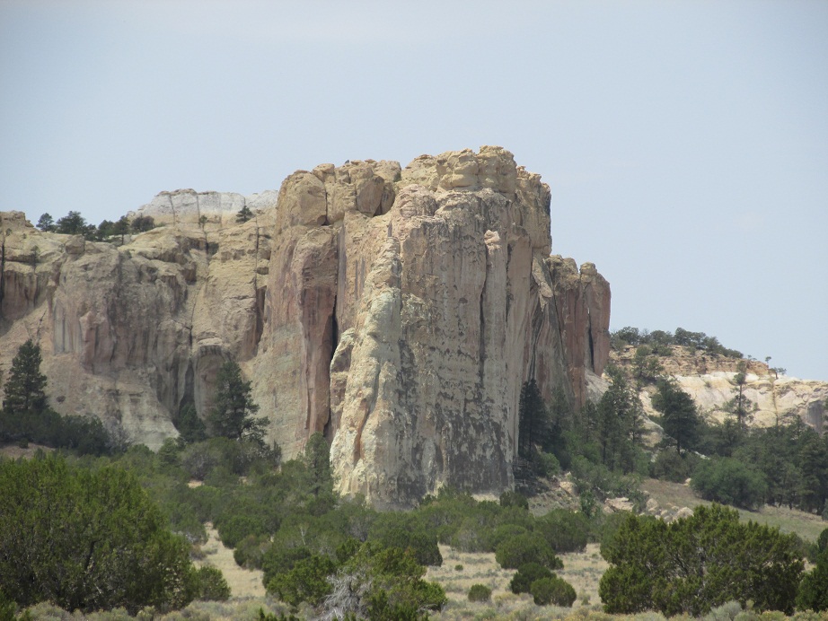 |
| Inscription Rock |
El Morro National Monument
Inscription Rock is a portion of the El Morro National Monument but is the main point to visit. On its top lie ruins of two ancient pueblos. A waterhole located at the base of the cliff made it a popular campsite for travelers.El Morro national Monument borders the Ramah Navajo Reservation. A short drive west and south of the monument is the town of Ramah New Mexico.
The monument was established in 1906 and is comprised of an area of two square miles. This is one of the smallest national monument's you'll come across although it is two square miles of unsurpassed beauty.Inscription Rock can be seen in several colors depending on sunlight and time of day. Mostly you will view muted shades of orange, red, grey and white.
 |
| Old El Morro School Gallery |
One of the first things to know about El Morro National Monument are the several other sites adjacent to it. In fact, El Morro is just one of the monuments you want to visit in the vicinity. This entire area of New Mexico is well known for the ancient volcanic activity that occurred there. El Morro does feature a nine space camping area but without hookups.
Two good sites to add to your New Mexico trip planner ar El Malpais National Monument and the Land of Fire and Ice.
El Malpais National Monument is about thirty miles to the southeast of El Morro and was established in 1987. Here you will view volcanic geology including lava flows, cinder cones, pressure ridges and complex lava tube cave systems. Some great hiking trails will also be found there.
See our Western Trips photo article about El Malpais National Monument on the link below.
El Malpais National Monument

Below is a link to our Western Trips photo article on the Land of Fire and Ice.
The Ice Cave and Bandera Crater
Traveling along Interstate 40 to El Morro National Monument or the other two mentioned nearby historic sites are best reached from Grants New Mexico. You'll want to exit Interstate 40 at Exit 81 and then turn left and drive southwestward on New Mexico Route 53.
(Content and photos copyright Western Trips)
View Larger Map