Located at 8,000 feet elevation on the continental divide in New Mexico, The Ice Cave offers a truly unique experience to anybody traveling through the southwest. This is an opportunity to go along a self guided tour to both of these fun and educational sites.I believe you'll find both of these sites well worth the drive.
 |
| Lava beds along the Ice Cave Trail |
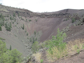
Western Trips had the opportunity to hike the trails and visit both the Ice Cave as well as the Bandera Volcano which the tourist can view today as a 1,200 foot wide crater. The crater is about 800 feet deep and you'll now see trees and shrub growing along it's sides and bottom.
The trail to the Ice Cave is about 400 yards in length each way. The trail from the trading post to the Bandera Volcano crater is about one-half mile each way and can be a bit strenuous but isn't a bad hike at all.
All of this geologic activity took place about 10,000 years ago when volcanoes in this area erupted and left an enormous amount of lava throughout the area. When you take the short hike from the trading post to the Ice Cave you'll walk a trail which is cut through a lava field. The trail will eventually lead to wooden stairs which go down to the Ice Cave itself. You'll marvel at how much the temperature changes as you walk down the steps.
 |
| Twenty foot thick ice |
The Ice Cave stays at a temperature that never rises about 31 degrees Fahrenheit. It's believed that man has been aware of this phenomenon for about 1,200 years. Early southwest settlers and U.S. Cavalry personnel who came across the site called it "The Desert Ice Box". In fact, it's been said that early settlers traveled to the cave to bring ice back home. Factors are such that the ice today remains undisturbed and appears in a blue-green color. The ice floor in the cave is 20 feet thick.
 |
| Stairs down to the Ice Cave |
The site of the Ice Cave and Bandera Volcano is in a geographical region of both forests and high desert. The Ice Cave itself is in a collapsed section of a lava tube. If you're traveling along Interstate 40 through New Mexico you'll view lava fields directly from the Interstate. This is all a part of the El Malpais lava fields which are a p[art of the larger Zuni-Bandera volcanic field.. The area is also referred to as the Zuni-Bandera Volcanic Field. This region was particularly active with ancient volcanoes and the lava fields stretch for dozens of miles.This is an amazing geologic area of the U.S.
 |
| Hiking trail to Bandera Crater |
The Bandera Volcano Crater with it's large dimensions is the largest crater in the region. The lava itself first breaking out from along the side of the cone was estimated to be above 2,000 degrees Fahrenheit. A volcanic eruption such as that with the Bandera Volcano typically occurs in these two stages, the formation of a cinder cone and then the eruption of lava. The lava flow that came from the Bandera Volcano is estimated top be twenty-three miles long. The crater itself over time tends to fill up with rocks and earth slowly falling into it. In a large way the crater is constantly evolving.
There are two additional sites to add to your New Mexico road trip planner and both are in the same general area of the state. Links below are to our Western Trips photo articles.
The El Malpais National Monument
Red Rock State Park
 |
| Bandera Crater |
Both trails are found at the Land of Fire and Ice located at the Ice Caves Trading Post, 12000 Ice Caves Road just south of Grants, New Mexico. Most reach the area via Interstate 40. You'll want to take Exit 81 and drive south on New Mexico Route 53 for about 26 miles.
The trading post where the trail heads are was built during the 1930's. At one time there was both a saloon and dance hall at the site. The tourism to the Bandera Crater and the Ice Cave began just after World War Two. The trading post exhibits some interesting artifacts that date back to over one thousand years and most were actually found in the lava beds.
I would recommend a stop at the Land of Fire and Ice for anyone traveling through New Mexico on Interstate 40. There are several other interesting and fun stops in the general area that are great companion trips. The map below shows you the location of the exact site in New Mexico.
(Photos from author's private collection)
View Larger Map

