Western Trips

Monday, October 29, 2012

Cape Disappointment / US Coast Guard


One of the finest venues in the United States to learn about the Columbia River, the Columbia River Bar and the history of this treacherous area of water is found at the mouth of the Columbia River. You will learn about Guard Station Cape Disappointment and the emergency services they render at the mouth of the Columbia River. The venue you want to add to your western road trip to Oregon is the Columbia River Maritime Museum located in Astoria Oregon. This museum has one of the largest displays of maritime artifacts and photos on the West Coast.It is the official maritime museum of Oregon.

oregon maritime museum
Columbia River Maritime Museum, Astoria Oregon
The museum contains six galleries and the Great Hall which showcases the maritime history on both the Columbia River and the Northwest Pacific Coast. Included are interactive activities for visitors of all ages. It’s one of the best stops to add to your Oregon family vacation planner.

The Treacherous Columbia River Bar

It’s very fitting to have such a large maritime museum in Astoria Oregon where the Columbia River flows out into the Pacific Ocean. It’s also fitting because one of the most elite of Coast Guard stations located there as well. This particular area where the Columbia River meets the Pacific Ocean sets up a big challenge to shipping. The Columbia River Bar Pilots have long worked the fierce winds and waves during winter storms. It is at this excellent museum that you can experience what these ships and bar pilots have encountered over the years. The Columbia River Maritime Museum presents this information with photos, artifacts and videos.

What is the Columbia River Bar?

ocean emergency survival gear
Emergency survival enclosure
The Columbia River Bar, sometimes just referred to as the Columbia Bar, is a series of shoals and bars extending about three miles wide and about six miles long at the mouth of the Columbia River. The river water is flowing west into the Pacific Ocean and meets the ocean’s mostly westerly winds. When conditions are just right, tremendous wave action can occur in just a few minutes. In other words, conditions can change on a dime. Things can go from bad to worse quite quickly. This trait alone can make the Columbia Bar very dangerous. The river action seen at the mouth of the Columbia is unlike any other seen in the U.S. As a result, the U.S. Coast Guard has seen plenty of action in this area.

United States Coast Guard Station Cape Disappointment

Cape Disappointment Coast Guard Station is unique for a variety of reasons. In addition to being the home of the National Motor Lifeboat School the Cape Disappointment station also has the task of having to operate in some of the world’s most treacherous seas. The Columbia Bar is part of a very dangerous coastal area that actually extends northward to the northwest tip of the Olympic Peninsula in Washington State. There’s really nothing along either the U.S. Atlantic or Pacific coast quite like it. 

coast guard rescue craft
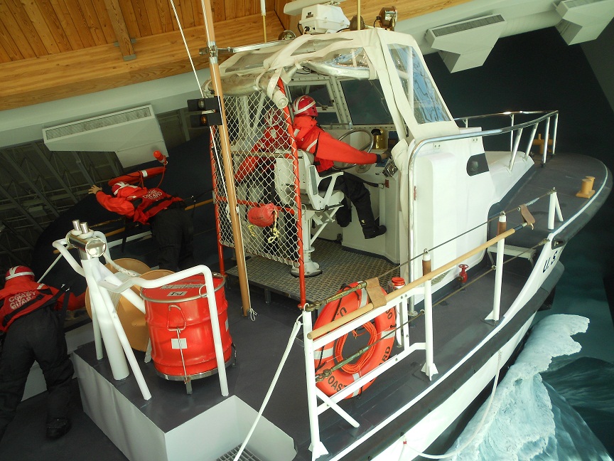
Coast Guard rescue boat exhibit
The Coast Guard Station Cape Disappointment is well equipped. The station boasts five search and rescue vessels ranging in length from 25 to 52 feet. The station has a complement of about fifty Coast Guardsmen. With these vessels and Coast Guardsmen, station Cape Disappointment is responsible for search and rescue of both commercial and recreational vessels in an area about fifty miles north and south from the mouth of the Columbia River. According to Coast Guard records, the Coast Guard Station Cape Disappointment receives anywhere from one hundred to two hundred calls a year for assistance. Most of the assistance activity occurs during the summer months when recreational boating is at its highest. 


The Columbia Bar Pilots

Just like in harbors all over the world, local ship pilots take over from the ship’s captain to safely guide the vessel around the local hazards. The difference with the Columbia Bar pilots is that they work in a very tricky environment. Columbia River Bar Pilots number about fifteen. Beginning in about October, the Columbia Bar pilots have their work cut out for them. This is when the fierce winter storms begin blowing in from the Pacific and head straight for the river’s mouth. While recreational boating begins to wind down, the larger ship traffic continues. Talk about dangers on the job, the bar pilots usually have to board the large ships by a rope ladder and many times in very heavy seas. The bar pilots do however have the authority to close the bar crossings if conditions warrant. 


coast guard rescue cutter
Coast Guard rescue exhibit showing pilot house
Avoiding Accidents at the Columbia Bar

Large vessels regularly transit ports in the Pacific Northwest. Due to their draft and for the most part their limited maneuverability, these large ships must navigate within the dredged ship channel. A good number of accidents happen when a tired crew thinks they can make a bar crossing even though weather conditions aren't right. Smaller vessels must always be cautious and also stay well clear of the large ships. In every instance the Columbia Bar must be crossed with caution. In some instances you might have a tug boat pushing a barge with a pretty large blind spot ahead of it. It's up to the smaller craft to stay well away. The Coast Guard advises small craft to cross the bar during the incoming flood tide and stay on the outer edges of the channel to avoid the large ships.

Capsizings of smaller vessels can occur due to improper loading and/or overloading. This situation makes the small vessel unstable and much more likely to take on water in heavy seas. Coast Guard Station Cape Disappointment reminds boaters to be aware of any warning signs. Warnings are displayed by two alternating amber lights. They appear when seas on the Columbia Bar exceed four feet in height.

Two additional photo articles you will enjoy are the Columbia River's Bonneville Dam and a Visit to the Columbia River Gorge Country

One of the best things about visiting Oregon are the number of day trips available within an hour or so from Portland. Whether you take a road trip east or west of the city, there are enough interesting and historic stops to fill up a weekend or an entire week. The book below is an excellent source to help plan your Orgon trip.


columbia river maritime museum
 The Columbia River Maritime Museum

The Columbia River Maritime Museum was the first Oregon museum to meet national accreditation standards. It is also designated as the official state maritime museum of Oregon. The museum is operated by a private non profit organization established in 1962 and is funded by membership dues, donations and admission fees. The Columbia River Maritime Museum has a reputation for the quality of it’s exhibits and the wide scope of it’s collections. It’s considered one of the best maritime museums in the U.S. The museum  is located at 1792 Marine Drive, Astoria Oregon.

(Photos from author’s private collection)

.

Friday, October 26, 2012

Loretto Chapel


The Loretto Chapel in Santa Fe New Mexico is a fascinating story and begins with the Sisters of Loretto. If you have an opportunity to visit Santa Fe, the Loretto Chapel, located just one block southeast of the Plaza is a must visit. By Spanish decree, the settlement of Santa Fe was designed around a central plaza. All roads radiated out from the plaza, most being very narrow and could be called alleyways. It is on the old Santa Fe Trail leading away from the plaza where the Loretta Chapel is located.

loretto chapel in santa fe new mexico
Loretto Chapel
The Sisters of Loretto Build a School

The Sisters of Loretto established the Academy of Our Lady of Light in 1853. This would have been about seven years after the United States annexed New Mexico Territory and only three years after the arrival of Bishop Jean Baptiste Lamy. Today's small settlement of Lamy New Mexico, about twenty miles southeast of Santa Fe is named in his honor.

Bishop Lamy encouraged the sisters to open up a female day and boarding school school in Santa Fe. This boarding school grew and grew over the next few decades. With the success of the school going well, the sisters believed that the next thing needed was a chapel. Funds were raised and in construction began in 1873 and the chapel was completed by 1878.

The Circular Staircase

loretto chapel staircase
Loretto Chapel staircase
One of the mysteries surrounding the Loretto Chapel has to do with it's circular staircase. It seems that when the chapel was completed in 1878, there was no way to reach the choir loft which was over twenty feet above the chapel floor. Carpenters who were consulted that there was not sufficient room inside the chapel for a conventional staircase and that a ladder would be required. The story continues that to find a solution to the choir loft problem, the Sisters of the Chapel made a novena to St. Joseph, the patron saint of carpenters.

On the very last day of the sisters prayers a carpenter with a toolbox and a donkey showed up at the Loretto Chapel. The man said he was looking for work and the sisters hired him for the job. What resulted from the work of this unnamed carpenter, which some say took months, although other versions contend that it was built fairly quickly, was a spiral staircase with two 360 degree turns. The Loretto Chapel staircase rises solidly in a double helix without support of any kind and without nail, screw or any type of metal. When the job was completed the carpenter left without asking for pay or even a thank you.

The Carpenter Vanishes

There was a big effort to locate this man. Nobody in Santa Fe knew who he was. There were no bills whatsoever for the sisters or the Loretto Chapel at the local lumberyard. To this end, an ad was placed in the newspaper but without results. The sisters came to believe that the carpenter who mysteriously showed up at the chapel and then vanished was St. Joseph himself. In any event, many people believed that the work of the spiral staircase was inspired by St. Joseph himself as the result of the sisters prayers.

loretto chapel interior
Loretto Chapel Altar
The carpenters work became known as the "miraculous staircase". When you view the Loretto Chapel staircase the first thing you realize is that it has no visible means of support. The carpenter constructed the staircase using only wooden pegs. Architects who have seen the staircase marvel at how it has survived these many years  and stays in place. Many have thought that the staircase should have collapsed on it's own years ago.

Two additional Western Trips photo articles you'll find interesting are Galisteo Church and the Spanish Mission, San Francisco de Asis in Rancho Taos.

Also, see the Santa Fe Plaza Cam located in the heart of Santa Fe New Mexico.

Thousands of Visitors Annually

Thousands upon thousands of people from all over the world have visited Loretto Chapel to see the "miraculous staircase". As mentioned above, this is a must stop when visiting Santa Fe. People who view the staircase cannot quite understand how it was built. Television specials as well as movies have been produced about the chapel and it's unique staircase.

There are questions regarding the number of risers used in the construction relative to the height of the choir loft. Also, questions about the type of wood used in the construction. Knowledgeable people were brought in to identify the wood used. It was concluded that the wood was not from the area. To this day the wood has not been specifically identified. Some think that this is not uncommon but to the people who do believe in this miracle in Santa Fe, the fact that the origin of the wood hasn't been found is indeed significant. What is universally agreed upon is that the construction itself was very innovative for the era.

choir loft at loretto chapel
Choir loft at Loretto Chapel
The Loretto Chapel staircase was completed without a railing. The sisters were concerned about this and in fact were afraid themselves to go up and down. About ten years after the staircase was originally built, a local artisan was brought in to add a railing.

Possible Explanations Put Forth in Books

Books have been published that claim to have solved the many questions of the "miraculous staircase". Some have identified the carpenter as a Frenchman who was well known. As to the wood used...some have contended that it was imported from France. If indeed you accept the premise that the Sisters of Loretto did make a serious effort to find out the carpenters name and went as far as placing an ad in the Santa Fe "New Mexican" newspaper, then you would have thought the carpenter could have been easily identified. The detractors of the legend claim that the carpenter was a well known figure. The legend from the sisters contends otherwise. It's an interesting story and it's something each one of us will have to determine ourselves after visiting Loretto Chapel along with reading up on more of the chapel's history.

Visit Loretto Chapel

The staircase has been closed to public use since the 1970's although it's recognized as still usable.This former Catholic church which is now privately owned  is used as a museum as well as a venue for weddings. The church is adjacent to the Inn of Loretto, one of Santa Fe's many popular close in hotels. The La Fonda Hotel is one-half block north of the chapel.  The address of the Loretto Chapel is 207 Old Santa Fe Trail.

(Photos from author's private collection)


Wednesday, October 24, 2012

St Helena California

The founding of St Helena California had a lot to do with Mexican land grants. The Mexican government granted a large part of the upper Napa Valley to a doctor from England. The doctor, Edward T. Bale, was one of the many pioneers who arrived in Alta California during the early 1840’s. Dr. Bale then traded off sections of his very large land grant to American pioneers who arrived on the scene between 1844 and 1846. Many Americans were arriving in California at a time when Mexico was involved in a conflict with the U.S.

hotel st helena california
Hotel St Helena
 Americans Arrive in California
The Bear Flag Revolt was a result of this large American immigration into California at a sensitive time. The Bear Flag Revolt resulted in an attack on the Mexican headquarters in Sonoma. Not too long afterward California was annexed into the United States as a result of the peace agreement with Mexico. As we all know, the California Gold Rush which began very shortly the annexation changed things in the Golden State in a big way. In fact, California gained statehood in 1850, just a few short years after the American government took over the region.

Beautiful St. Helena California
Where St. Helena California is today was once the home of Native American people who were called the Onastis, which translates to the "outspoken ones." The Spaniards and the Mexicans after them called these people the "Wappo," The tribe was considered warlike and as such the name translate into "brave," or "handsome." 
The first settlers to the area were farmers. As early as the year 1860, some of these farmers determined that the soil was advantageous for growing grapes. Two men are considered the pioneers of the Napa Valley wine industry. These were Dr. George Beldon Crane and Charles Krug. Interestingly enough, the areas very first resort, White Sulphur Springs, opened in 1852. The wine industry grew considerably in the region and would not be seriously affected until January 1920.

St Helena California architecture
St. Helena California and several other wine country towns were able to keep their rural setting in place partly due to the  their location. During the age of stagecoaches, getting there was not the easiest thing to do,  mostly because of the hills. This kept the rural atmosphere intact for quite a long time. In fact, today you would still call it rural. There is no heavy industry in the area and therefore the population growth was slow. St. Helena was fortunate to keep hold of  it’s agricultural heritage and the rural character is kept that way today by design.

Prohibition and the Great Depression Years
Like the entire nation, in 1920 St’ Helena was affected by the passage of the 18th Amendment. If you’re growing grapes and selling wine, this was not a good thing. Despite the new law, Napa County and St. Helena continued to attract tourists. The road traffic to St’ Helena during the dry years to buy bootlegged wine was so large that little Highway 29 was considered the state’s second busiest road. When you look at a map of Napa Valley , you'll see that Hwy 29 is it's main artery. Prohibition lasted some thirteen years until the law was repealed. At that time however the nation was in the grip in what would become the Great Depression.

st helena main street
Main Street, St Helena
The Great Depression put a damper on the sale of premium wine and as a result St.’ Helena became more quiet and more rural. It actually lasted that way for several decades until the American wine industry took off again in the early 1970’s. During that decade Americans took to the road to enjoy the fine wines produced in and around St. Helena as well as the beautiful hills the general landscape and elegant architecture of the area. It has continued ever since.

Things to Do in St. Helena
It’s interesting to note that about 95 percent of the vineyards in St. Helena are family owned. Among the many events going on each year in St. Helena is the Easter Egg Hunt, free summer outdoor concerts, the Harvest Festival Pet Parade and the very popular Annual Wine Auction put on by the Napa Valley Vinters Association. St Helena Wineries are fun to visit.

The Charles Krug Winery, established in 1861 by this Prussian immigrant, is the oldest winery in Napa Valley. Krug made his first commercial wine in the town of Napa in 1858. Charles Krug became the major local winery figure in Napa Valley of his era. He influenced Napa Valley's development as a world renown wine producing region.

shopping in st helena california
Shops of St Helena California
You’ll also find interesting our article and photos on the Buena Vista Winery in the town of Sonoma. The Buena Vista Winery was the first commercial winery established in Sonoma County. 

In St. Helena you will also want to explore the Berringer Winery Historic District. This is one of the most popular sites in Napa Valley. This includes six buildings and three structures. The address is 2000 Main Street.
Another area of note is right in the middle of St. Helena. This is the St. Helena Historic District along Main Street between Adams and Spring Streets. Among the historic buildings you’ll see thirteen cast metal street lights with Doric Columns and triple globes.

A very short drive north of St’ Helena is the Bale Grist Mill. The Bale Grist Mill State Historic Park is a grist mill that was built prior to California’s statehood. It’s a great side trip to add to your itinerary. The park is located just three miles north of St. Helena in Hwy 29.

See our Western Trips articles and photos of the Bale Grist Mill.and Things to See and Do in La Jolla California

When your western travels take you to the beautiful California wine region, make sure to make a stop at the very historic town of St Helena. The St Helena restaurants are great, the town is elegant and the choice of fine wineries are numerous. Some of the best Napa wineries you'll find are all around St Helena. You'll also get some terrific St Helena pictures of the town's unique architecture.

(Photos from author's private collection)


Sunday, October 21, 2012

The Frontier America


1800s horse carriage
Late 1800's Carriage

The subject of the Frontier America is one of our country's biggest stories. In a large way it was all about Manifest Destiny, the U.S. self given mandate to occupy North America from the Atlantic Ocean to the Pacific.

One of the best ways to learn about life during the days of western settlement is to visit some of the smaller museums spread throughout the western states. They make an excellent as well as economical addition to your western road trip planner. Many of these smaller museums are free to browse in. Most are operated by historical societies. Visitors can donate whatever amount they wish. At other museums the fees are nominal. These museums are also terrific side trips for the entire family. And are filled with historic artifacts and photos.

Frontier America involves all kinds of history. The Oregon Trail, the Indian Wars, the gold mining booms, the Mexican American War, stagecoaches and railroads and the building out of towns and cities that were at one time merely camps. It's a fascinating subject and the artifacts, photos and exhibits at small town museums do a great job in telling the story. You’ll also find well informed docents who can answer just about any of your questions.


fort stockton barracks
Enlistedmens Barracks, Fort Stockton Texas
Fort Stockton Texas- Fort Stockton is located on Interstate 10 in southwest Texas between El Paso and San Antonio. During the mid 1800’s this was a very important army fort in frontier America with a variety of tasks. One was to protect the stage and freight lines that mostly traveled west out of San Antonio. Both the Comanche Indians and to a lesser extent the Apaches roamed the region. Fort Stockton was not built in the stockade style but rather with buildings on all four sides of a center parade ground. Today, Fort Stockton, which is the same name of the city it now resides in, is a National Historic Site and a great place to see and learn about the old west Texas days. The fort features a walking tour all around the parade grounds with several interesting buildings open for exhibit. This includes the old guard house, officers quarters and elistedmens barracks. In addition to these is a very interesting museum and gift shop. In the museum you’ll view a lot of authentic artifacts of frontier America. These includes many frontier firearms such as a Sharps rifle, cavalry and infantry uniforms, saddles, canteens, an army bugle and other personal items. You’ll also find a lot of information about the Buffalo Soldiers who at one time were stationed at Fort Stockton.

More photos and information about Fort Stockton is in our Western Trips article about the historic west Texas fort.

Another site in Fort Stockton you’ll want to add to your trip planner is the Annie Riggs House. The Annie Riggs House was a frontier hotel with quite a lot of history. A tour of the Annie Riggs House features period artifacts along with fully furnished rooms. It’s definitely worth the stop while in Fort Stockton.


red river museum in vernon texas
Red River Museum, Vernon Texas
The Red River Valley Museum- The Red River Valley Museum is located in Vernon Texas and is all about the cattle ranching days in north Texas. A terrific display of artifacts are exhibited with a room dedicated to the old Waggoner Ranch which occupied much of the area. Frontier firearms, carriages, musical instruments and much more are exhibited.

The Red River Valley Museum does an excellent job in telling the story of the frontier cattle days in Texas. Another interesting thing about the museum and Vernon Texas is that it was on the old Texas Trail which started on the Rio Grande in south Texas and eventually extended with additional routes that led all the north to the Canadian border. Various parts of the Texas Trail went by different names, especially in the northern sections. The Texas Trail sometimes referred to as the Great Texas Trail was the longest of any of the old cattle trails. Just a few miles northeast of Vernon is a place called Doan’s Crossing. Doan’s Crossing is on the Red River which in the 1800’s was the Texas border with the Indian Territory, now present day Oklahoma. Doans's Crossing represents the spot where the Texas Trail cowboys drove their herds across the river and into Indiahttp://westerntrips.blogspot.com/2014/08/visit-truckee-california-and-its.htmln Territory on their way to the Dodge City Kansas rail heads.

See our Western Trips article and photos of the Red River Museum in Vernon Texas and a Visit to Truckee CA and It's Historic Hotel


navajo county courthouse
Old Navajo County Jail exhibit
Holbrook Arizona- Holbrook Arizona is directly on Interstate 40 in northeastern New Mexico and adjacent to the Navajo Reservation. The place you want to stop by in Holbrook is the old Navajo County Courthouse which today is a fascinating frontier America museum. The courthouse is located at the northeast corner of Arizona Street and Navajo Blvd. In 1976 a new center of government was established just south of Holbrook and the old courthouse remained vacant for about five years. At that point the Navajo County Historical Society obtained artifacts from local residents and opened the museum. Home furnishings, historical papers and many other artifacts tell the story of this old west pioneer town. You’ll also see an old 46 star flag which represents the time before Arizona gained statehood. Navajo County Arizona was created when the Arizona Territory Legislature voted to slice off a narrow piece of Apache County. Both Holbrook and Winslow Arizona competed to be the new county seat and Holbrook won out. The courthouse construction was completed in December of 1890.

There is a section of the building which was the old sheriff’s office and jail. The jail you will see is one of the oldest jail exhibits in the west and was constructed in the east and shipped to Holbrook by rail.

See our photos and history in our Western Trips article about the Navajo County Holbrook Courthouse Museum.


charles bent house in taos new mexico
Charles Bent House and Museum

 Charles Bent House- The Charles Bent House is located in Taos New Mexico, about an hour and a half drive north of Santa Fe. Charles Bent was the very governor of the New Mexico Territory. The New Mexico Territory was created after the Mexican American War in the latter part of the 1840’s. The territory was ceded to the U.S. from Mexico as part of the peace agreement. The Mexican government only controlled New Mexico for about twenty years after they expelled the Spaniards from North America in the 1820’s. The first years of territorial government were rugged times in New Mexico in as much as there were so many diverse cultures there. The territory was essentially Spanish and Mexican with a large population of Native Americans. Loyalties at first were all over the place. The Indians always had a mixed relationship with the Spaniards and later Mexicans and the introduction of American rule just added to the diversity of interests.

You’ll be interested in our photos and article of the Charles Bent House Museum.

Unfortunately for New Mexico Territory’s first governor, there were plenty of hostilities to go around. Governor Charles Bent was killed in a massacre at his home in Taos in 1847. There are a few versions of what exactly occurred but the prevailing story is that a group of disgruntled Mexican soldiers along with some northern pueblo Indians made an attempt to oust the Anglos from New Mexico. Charles Bent was shot when standing in the doorway of his home and died soon afterward. More Anglos were slain north of Taos. The rebels were subsequently defeated by the U.S. military who arrived from Santa Fe. Today, the old Charles bent Home is an interesting museum filled with artifacts of the era. Indian artifacts, firearms of the period, home furnishings, musical instruments, photos and more are all on display.

There's a great many small frontier America  museums all over the western U.S.  Hopefully you'll have the opportunity to add some of these to your road trip itinerary.

(Photos are from author’s private collection)

Thursday, October 18, 2012

Fort Vancouver / Hudsons Bay Company


fort vancouver stockade
Bastion at Fort Vancouver
Fort Vancouver and the Hudson's Bay Company is arguably the most significant story about the very beginnings of commerce in the Pacific Northwest. For many years, Fort Vancouver was the headquarters of the British presence in what is now the states of Washington, Oregon and Idaho.

If your vacation or short trip plans take you to the Portland Oregon area, a visit to Fort Vancouver is a must stop. It's a beautiful site to visit and explains much of the very beginnings of settlement in the Pacific Northwest.


The British Stronghold in the Pacific Northwest

In a real sense the Hudson's Bay Company represented the British interests in the Pacific Northwest. The fur trapping company was the point of the spear as opposed to the British military. Fort Vancouver functioned as the main supply base and administration site in the American northwest for the Hudson's Bay Company which itself was headquartered in London England.

hudson bay company counting house at fort vancouver
Hudson's Bay Company Counting House
The British and the Americans both had trappers in the northwest for some time and an arrangement was made to allow trappers from both sides to share the region. The Hudson's Bay Company took a big step to solidify their hold by establishing Fort Vancouver. Fort Vancouver replaced Fort George which was at the mouth of the Columbia River at present day Astoria Oregon. Fort George had originally been called Fort Astoria when John Jacob Astor's fur company briefly occupied the fort. The Astoria fort and equipment were sold to the Hudson's Bay Company by Astor. Not long after they established Fort George, the Hudson's Bay Company decided to relocate further inland along the Columbia River. The new Fort Vancouver is in present day Vancouver Washington just across the Columbia River from Portland Oregon.

An interesting historic side note regards a man who served as Chief Factor at Fort Vancouver, John McLaughlin, who is credited as the founder of what is today Oregon City, Oregon on the Willamette River just a few south of Portland. McLaughlin had a fine reputation at the fort and was known to give aid to pioneers and trappers who arrived there in need. John McLaughlin also offered Oregon Trail pioneers food and medical aid which was against the official policies of the Hudson's Bay Company. Eventually, McLaughlin left Fort Vancouver and settled in Oregon City and built a sawmill on the east side of the Willamette Falls.

See our Western Trips article and photos of Oregon City.

hudsons bay company counting house
Counting House exterior
The Trappers Head Out

Beaver hats were very popular. The Hudson's bay Company sent out brigades which included perhaps 50 to 100. These included men, women and children. The earliest of trappers used the same methods as the Indians. This was breaking into a beaver lodge and simply taking the animals. Not soon afterwards, this gave way to the baited steel traps. After spending about a year away from the fort, the trappers prepared to journey back to Fort Vancouver.

Their arrival back at the fort was a time of celebration. The trappers and their boats arrived via the Columbia River with their pelts and wore some of their most colorful clothes. Their arrival was in the atmosphere of a festival.

The American Takeover

All stories of the famous Oregon Trail depict how thousands upon thousands of pioneers traveled this 2,000 mile route from Missouri to Oregon. Officially, the Oregon trail began in Independence Missouri and ended at Oregon City Oregon. American influence obviously grew in Oregon as more and more settlers arrived. As a direct result, the region was divided between the British and the Americans in 1946 at the 49th parallel. This division placed Fort Vancouver on American soil. The Hudson's Bay Company continued to operate at the fort for years afterward. At the same time in 1849 the U.S. Army established an outpost at the fort. The army named the fort Columbia Barracks and then renamed it Vancouver Barracks. The fur trade was declining for the Hudson's Bay Company and the U.S. was involved in various Indian Wars in the vicinity and throughout the west.  It wasn't until 1860 that they abandoned the fort altogether to the Americans. Six years later a fire destroyed all of the original fort.

fort vancouver fur warehouse
Fort Vancouver fur warehouse
The fort continued to be used by the U.S. Army through World War One and World War Two.During the First World War it was the home of the Spruce Division and in World War Two was the staging area for the Seattle port of embarkation.

Two additional Western Trips articles you'll find interesting are A Visit to Sutters Fort in Sacramento California and the Six Month Journey on the Oregon Trail.

Fort Vancouver Today

An excavation of the old site of Fort Vancouver took place beginning in 1947. According to National Park Service information, some two million artifacts were discovered at the excavation site. During the years during and after the excavation there were those who desired to keep the area an archeological site. In  1954, the area was was officially designated a site to preserve the history of the Hudson's Bay Company. In 1965 Congress gave the go ahead for a complete reconstruction. 

Fort Vancouver National Historic Site today is a reconstruction of the old Hudson's Bay fort as it would have appeared in the early 1800's. The reconstructed buildings within the Fort's walls are on their original sites. Adjacent to the fort is Pearson Field which today is operated as a city owned small aircraft field but does have the distinction of being the oldest operating airfield in the United States.

fort vancouver blacksmith shop
Fort Vancouver Nat'l Historic Site Blacksmith shop
Visiting Fort Vancouver National Historic Site

Fort Vancouver National Historic Site is easily accessible and makes a great addition to your Oregon western trip planner. The site is just across the Columbia River from Portland Oregon in Vancouver Washington. The two cities are connected by the Interstate 5 bridge. When on Interstate 5, turn off at the Mill Plain Blvd exit and follow the signs to the fort's Visitor Center which is on East Evergreen Blvd. At the Visitors Center you can obtain detailed maps which can be used for your walking tour. The Visitors Center is located on a hill just north of the fort. The walking tour map information contains details of each of the site's structures. 

The Fort Vancouver National Historic Site Visitors Center showcases interesting exhibits and offers visitors the opportunity to view several short films by request. It's one of the best sites to learn about the settlement of the Pacific Northwest.

(Photos from author's private collection)

Monday, October 15, 2012

Bonneville Dam


bonneville dam
Bonneville Dam
When your western trip takes you to the beautiful country of the Columbia River Gorge in Oregon, there is a very fun, educational and informative stop you will want to add to your road trip planner.

The Bonneville Dam, located about forty miles east of Portland Oregon, is a great travel stop for the entire family. Not only do the exhibits at the Bonneville Dam explain how the dam operates and produces hydro-electric power, but also how the fish of the Columbia River navigate themselves upstream past the dam to spawn. It's really a fascinating story and the way it's presented at the Bonneville Dam visitor center is quite unique and entertaining.

A trip to the Bonneville Dam is an excellent addition to your Columbia River Scenic Highway sightseeing agenda.

The Great Challenges of Building the Bonneville Dam 

The U.S. Army Corps of Engineers has been involved in the Columbia River Gorge since the late 1870’s. It was then that they constructed the Cascade Locks. The locks were badly needed to help improve Columbia River navigation past the Cascade Rapids. When some of the early Oregon Trail pioneers chose to proceed down the Columbia River in the 1840's, the river's rapids were quite a challenge, often times a deadly one.

See our Western Trips photos and article on Oregon City, the end of the historic Oregon Trail.

electric turbine diagram
Diagram of how a turbine operates to produce electricity
The Bonneville Dam was constructed in 1938. Construction time took about five years. It's second power house was added in 1982. The dam is owned by the U.S. Army Corps of Engineers. It is the first of eight locks and dames along the Columbia and Snake Rivers. Finding a suitable location to erect a dam can be difficult. In the case of the Bonneville Dam, the site chosen had ample bedrock to provide the all important foundation for the dam. Construction of the dam presented many challenges. These included the depth of water, the speed of the river's current, the harsh weather conditions, and the annual summer flood caused by mountain water runoff. In addition to these challenges, constructing the Bonneville Dam also meant that miles of roads and rail tracks would have to be relocated and massive timbers were employed to help divert water away from the construction site.

At the time of construction, the Bonneville Dam was built for two initial reasons. One was to add jobs during the country's Great Depression. The other was to provide needed hydro-electricity to the Pacific Northwest. The proposal for a dam on the Columbia River was also a presidential campaign pledge of Franklin Delano Roosevelt.

bonneville dam electric turbine
Old turbine exhibit at Visitors Center
Hydro-Electric Power

Hydro-electric power at a dam is produced when water flows through it to the river below. A turbine is what actually produces the power as shown in the diagram. A turbine consists of metal coils surrounded by magnets. Electricity is made when the magnets spin around the coils. Obviously this is pollution free energy as opposed to coal fired generators.

The first power house built had 10 generators. These were brought online between 1938 and 1944 and had a generating capacity of 526,700 kw of power. The second powerhouse was constructed with eight generators that produced 558,200 kw. The hydro-electric power that the dam produces is sent to the Bonneville Power Administration grid. From there power can be sent to Oregon and Washington as well as a number of other northwestern states. Bonneville power had a big place in building America's northwest.


A Most Scenic Site

The Bonneville Dam is in the Columbia River Gorge which is arguably one of the most scenic areas in the United States. Driving there from Portland Oregon takes you along the Columbia River Scenic Highway constructed during the first part of the 1900's. On the way to visit the dam, tourists will pass by numerous falls and other historic sites which makes getting there a lot of fun.

bonneville dam locks
Bonneville Dam locks door
You will enjoy our Western Trips article and photos on the various water falls in that area. See the Columbia River Gorge.

 In 1986, the Bonneville Lock and Dam project was placed on the National Register of Historic Places and was later moved up to a National Historic Landmark.

Visiting the Bonneville Dam 

Getting to the Bonneville Dam Visitors Center requires all people and cars to pass through a security gate. The Bonneville Dam visitor's center is a separate building from the main powerhouse. The Visitors Center contains many exhibits explaining just how the dam produces hydro-electric power ans specifically about the history of the dam itself.

fish ladder at bonneville dam oregon
Fish ladder at Bonneville Dam
Of special interest is how the dam helps fish swim upriver which is essential for specie survival. Bonneville Dam fish exhibits are very interesting. It's educational to see the work done at the dam project to accommodate the various species of fish. The Visitors Center contains two levels.

On the lower level you can view through a glass wall the fish actually making their journey upriver. Just outside the Visitor Center you can view the "fish ladder" which allows the fish to essentially climb the river. This also allows for a Bonneville Dam fish count. A fish ladder is a series of pools arranged in ascending steps at the side of a stream, enabling migrating fish to swim upstream around a dam or any other obstruction. It's really a fascinating thing to see and ensures that the Columbia River fish ecological balance is retained. Adjacent to the dam is the Bonneville Fish Hatchery.

In the Bonneville Dam Visitor Center you'll also see exhibits about the old area history dating back to the Native American days. These were the early days of the Lewis and Clark Expedition and several decades later the migration of thousands of pioneers over the old Oregon Trail.

The Bonneville Dam Visitor Center also offers guided tours depending on the season. The Bonneville dam tour is very informative and you can actually go into the electricity generation building there.  Outside of the Visitors Center when you first arrive, take note of the large turbine wheel exhibit shown above from one of the original powerhouse turbines.

(Photos from author's private collection)


View Larger Map

Saturday, October 13, 2012

Hiking in New Mexico

Hiking in New Mexico is a fun activity to add to your western vacation. The state's topography along with the national and state parks and monuments are a hikers dream. Whether you're a novice or highly experienced hiker, New Mexico has a trail for you. Some of these are scenic and some are both scenic and quite historical.In fact, the Santa Fe area of Northern New Mexico is thought to be a hikers paradise. Hiking in New Mexico is just about for everyone and offers the full range of trails...easy to difficult.

In this article we want to highlight a few of the more popular and scenic hikes in Northern New Mexico. By all means, this list and description represents only a tiny sample of the Northern New Mexico's hiking and biking trails. The sample of New Mexico hiking trails described below all excellent day hiking routes and are easy to moderate in rating.

Some Interesting Trails


big tesuque trail in new mexico
Big Tesuque Trail
The Big Tesuque Trail- The trail begins at the Big Tesuque Campground on the Santa Fe Ski Basin Road (NM 475). This is about 12 miles north of Santa Fe in the Santa Fe National Forest and on the right side of the road. The trail begins on the other side of the road from the campground.

This is the Aspen Fir area of the beautiful Sangre de Cristo Mountains. This is a good day hike trail which is suitable spring through autumn. During autumn it's very popular for those wanting to see the golden aspen leaves that cover this part of the mountain.This is a 7.5 mile hike which is mostly downhill with a change in elevation of about 2,400 feet. You would want to leave a car at the Chamisa trailhead which is about 6 miles from the center of Santa Fe. This is considered a moderate hike.


aspen vista hiking trail santa fe
Aspen Vista Trail
Aspen Vista Trail- The Aspen Vista Trail starts at an elevation of 9,800 feet and ends in six miles at Tesuque Peak.The trailhead is located along the Hyde Park Road also called the Santa Fe Ski Basin Road (NM 475). The trailhead location is 13 miles north of the Santa Fe Plaza.

 This is a wide trail and actually a road which is closed to vehicles and to snowmobiles. It is an excellent cross country ski and snow shoe trail. Aspen Vista is another excellent trail to view the beautiful gold aspen leaves as they change to a golden color in early autumn. The best aspen viewing time is usually the first week or so of October. Similar to the Big Tesuque Trail, the Aspen Vista Trail traverses the Santa Fe National Forest in the Sangre de Cristo Mountains.


chamisa trail in santa fe national forest
A view from the Chamisa Trail
Chamisa Trail-This is another great New Mexico hiking and mountain bike trail close in to Santa Fe. The trailhead starts at Hyde Park road (NM 475) and is 2.5 miles in length. The trail eventually joins into the Winsor Trail. At the start there are two trails. The one you want to take is the one that immediately begins to climb. Your elevation will go from about 7,800 feet to 8,500 feet. The trail is rated as advanced and has steep grades but is still very good for mountain bikes. Just as with the two trails listed above, the Chamisa Trail is an excellent day hiking route. It's also an excellent trail for taking your dog along. When you reach 8,500 feet the trail will start to go downhill until it joins up with the Winsor Trail. The downhill portion goes into the Big Tesuque Creek basin where you can enjoy wildflowers and a beautiful green meadow.

The Chamisa trailhead location is the parking area on the left side of Hyde Park Road aboutsix miles north of the Santa Fe Plaza. You will be interested in our Western Trips story and photos on the Great Divide Mountain Bike Route.

cerrillos hills state park trails
The trails at Cerrillos Hills State Park
Cerrillos  Hills State Park Trails- Hiking in New Mexico can be a historic adventure as well as a scenic trek. This is a lower elevation group of trails located with the Cerrillos Hills State Park just north of the town of Cerillos. Cerrillos was a booming mining town located along the popular Turquoise Trail just south of Santa Fe. The historic mining town of Cerrillos itself is about 25 miles south of Santa Fe. This was once a big mining town with four hotels and more than a dozen saloons. The terrain is quite a bit different as compared with the two higher elevation hikes described above. Rather than a hike through the woods, the Cerrillos Hills cover rocky rolling terrain. There are about 5 miles of trails at Cerrillos Hills.

One of the fun things about the trails at Cerrillos Hills is that they pass by old abandoned and closed up mines from the 1800's. Along many of the trails, hikers will discover many sealed mines, most with interpretive signs providing information about the region during its heyday. Mining in this region included gold, silver, turquoise, zinc and lead. The views on these well maintained trails are terrific.

Additional photos and articles you'll enjoy on our Western Trips site are Historic Cerrillos New Mexico and Gila County Arizona History and Hiking and Hiking the Crescent Moon Ranch Trail in Sedona Arizona

The two books listed for sale at the top of  this article are among the excellent hiking trail books on the market. In addition to the New Mexico trails described in the Falcon Guide, the Pacific Crest Trail hike is another very adventurous journey you'll find quite interesting.

Hiking in New Mexico is a fun addition to any western road trip planner. More information regarding the Sangre de Cristo Mountains, the Santa Fe National Forest and Hyde Memorial State Park can be found at New Mexico Parks and at the USDA Forest Service Santa Fe National Forest site.

(Photos from author's private collection)

Thursday, October 11, 2012

San Francisco Cable Cars


San Francisco cable cars are as much a part of the history of San Francisco as is the Golden Gate Bridge, Fishermans Wharf and Telegraph Hill. If you have an opportunity to visit San Francisco, one very fun and educational stop to make is the Cable Car Museum. There is no charge to visit the museum.

Cable cars roll through the streets of San Francisco with their clanging bells everyday. It's one sure way to travel up and down the highest sloping streets.The Cable Car Museum not only showcases vintage San Francisco cable cars, cable car mechanisms and their fascinating history but also lets you see for yourself just how the system operates today.

The San Francisco Cable Car Museum is located in the Nob Hill area of the city. The museum is also a part of the cable car power house which operates the underground cable system today. A visit there is a visit to a museum as well as the working power house. While the power house itself is off limits to visitors, there are two galleries which allow you to see the cables and machinery in action. There is also a section underground where you can see the cables operating under Washington and Mason Streets.

cable car power house
Cable Car Power House
The Need for a Better Way

Cable cars was just what the public needed to get up and down the city's steep streets. The first San Francisco cable car was tested in 1873 by Andrew Smith Hallidie. Hallidie came to California from Great Britain during the early gold rush years. The very idea of a cable car began when Hallidi noticed how difficult it was for horses trying to handle the steep slopes of the city. There were instances where horses slipped on the wet streets and were dragged to their death. Another challenge for horse drawn wagons was the downhill leg where wagons, due to gravity, would dangerously push against the pulling horses and cause accidents and sometimes death. The horse and buggy worked well almost everywhere except on those steep hills of San Francisco.

Andrew Smith Hallidie had the knowledge to put his idea to the test. His father had a patent on a "wire rope" cable in England. When Hallidi mined for gold during 1852 he used cables to help haul ore from the mines as well as developing cable for suspension bridges. It was with this background that Andrew Smith Hallidie was able to patent his cable car system.

cable car grip
Cable Car "grip" mechanism
The Fast Growth of Cable Cars

The very first San Francisco cable car line was the Clay Street Hill Railroad, a partnership that Hallidie entered into. Service started in September of 1873. It didn't take long for the successful venture to spawn other operators. During the first four years, the Clay Street Hill Railroad was the only operator. The next was the Sutter Street Railroad which operated its own version of Hallidie's patented system and began cable car service in 1877. The next was the California Street Cable Railroad 1878. Then in 1880 it was the Geary Street, Park & Ocean Railroad followed by the Presidio & Ferries Railroad in 1882, the Market Street Cable Railway in 1883, the Ferries & Cliff House Railway in 1888 and then the Omnibus Railroad & Cable Company in 1889. Obviously, the cable car systems were quite popular with the public. When all was said and done, some 53 miles of track had been laid in San Francisco.

Consolidation 

Over the years, cable car companies expanded and merged. The Market Street Cable Railway would eventually emerge as San Francisco's largest. It would be renamed the Market Street Railway Company.


The significant event that meant a permanent change to the original cable car routes was the San Francisco Earthquake and Fire of 1906. The cable car map would be changed forever. For one thing, the devastating earthquake would give the Market Street Railway Company, which then was renamed the United Railroads of San Francisco, an opportunity to abandon certain cable car routes in favor of the cheaper to operate electric streetcars. The only cable cars lines to remain after the city had rebuilt itself were those on the steepest of streets. In 1918, mostly due to labor troubles, the United Railroads of San Francisco would again be reorganized and renamed the Market Street Railway Company.

clay street hill railroad cable car
Original Clay Street Hill Railroad, Number 8
The Electric Streetcar

At about the time that the cable car system was at it's heyday in San Francisco, a man by the name of Frank Sprague developed the electric streetcar in 1888. With the exception of some of the steeper hills in San Francisco, the electric streetcar was much more versatile then the cable car and it's building and operating costs were less. Regardless of the economy of the electric streetcars, many people did complain about the miles and miles of wire above city streets. It simply didn't look that great and because of this many still favored the cable car.

See our Western Trips article on the Electric Streetcars of San Francisco. You will also enjoy the article, Interurban Railroads of the San Francisco Bay Area. Also See These Carson City Nevada Historic Sites

Believe it or not, in 1947, the then mayor of San Francisco floated the idea of just getting rid of the cable cars altogether. Fortunately for all of us his idea met with stiff resistance most notably from the Citizens' Committee to Save the Cable Cars. The true value of the cable cars to San Francisco was proven. aside from whatever fares are collected from riders, the cable cars gave San Francisco a true distinction from other large cities. The tourism value of the cable cars is obvious. It's often said that tourists don't travel to San Francisco to ride the buses. While San Francisco certainly offers many fine attractions, both historical and otherwise, the cable car and it's history is in a class all it's own.

cable car wire
Roll of cable car wire
Today's Cable Car Lines 

Today, San Francisco has three different cable car lines. They are the California, the Powell-Hyde and the Powell-Mason. The San Francisco Municipal Transportation Agency operates all three lines. Depending on the time of day, single ride fares as of this writing range from $6 to $3. All day passports can also be bought for $14. Monthly passes are available and the cable cars are available for private charter. Many people begin their cable car ride at the intersection of Powell and Market Streets in Union Square. There you'll find the a booth for cable car tickets.

Another popular starting point is at the Fisherman's Wharf area. Two of the three cable car lines stop in Fisherman’s Wharf. You can board the Powell-Mason line at Taylor St. and Bay St., or the Powell-Hyde line at Hyde St. and Beach St.

Visit the cable Car Museum

You'll have a fun time touring the San Francisco Cable Car Museum. See first hand just how these historic San Francisco cable cars operate today. The Cable Car Museum is located at 1201 Mason Street, just a few blocks north of Nob Hill.

(Photos from author's private collection)