Western Trips

Friday, August 30, 2013

Historic Churches / St. Paul Minnesota


The church shown in this photo article, the Cathedral of Saint Paul, is over one hundred years old. This magnificent cathedral, built in the Classical Renaissance style with it's marble pillars, granite walls and stained glass, compares today to any of the great cathedrals built in Europe.

The Cathedral of St.Paul is located appropriately in St. Paul Minnesota on the east bank of the Mississippi River. This beautiful cathedral is filled with history. It's a must stop if your travels take you to or near St. Paul Minnesota. The address is 239 Selby Ave, St Paul, MN . It's estimated that a quarter million people tour the cathedral annually.

cathedral of st paul minnesota
Cathedral of St. Paul
The first church in this area was constructed in 1841 and consisted of a log chapel. The church you see today was constructed by immigrants during the years 1906 to 1915.

Archbishop John Ireland

The church you see today was inspired by Archbishop John Ireland in 1904.  Born in Ireland, he came to the St. Paul area with his family. The Most Reverend John Ireland served as the Diocese of St. Paul's first Archbishop from 1888 to 1918, the year that he died.

One of the most enduring accomplishments of the Archbishop was his bringing of Irish Catholic families from the slums to the vast farmlands of Minnesota. There they were able to start anew and out of this were established new schools and new parishes. Reportedly, during his tenure and with the many Irish Catholic's moving to the area, five new dioceses were created in 1889. Archbishop John Ireland was also very well known for his work in developing education in his parishes.

historic church in st paul minnesota
View of Cathedral of St. Paul from another angle
During the Civil War John Ireland served with the Fifth Minnesota regiment and was always prepared to pray with it's soldiers and offer any spiritual comfort he could. As it turned out, the Fifth Minnesota played a major role in the key Battle of Corinth in 1862 which stopped a Confederate breakthrough. Father John Ireland left the Union Army in 1863 due to ill health.

One of the Largest Cathedrals in The United States

In addition to the beautiful stained glass, the marble pillars and the shining granite walls mentioned above, the Cathedral of Saint Paul features a stunning gold dome.

The dome of the cathedral shown in this article measures 76 feet in diameter and 186 feet high. The granite walls mentioned above were obtained from a quarry in nearby St. Cloud. The church has twenty-four stained glass windows.


st paul cathdral dome
Beautiful gold dome at Cathedral of Saint Paul
In 2009 the Cathedral of Saint Paul was designated the National Shrine of the Apostle Paul by the U.S. Council of Catholic Bishops and the Vatican.

 St. Paul Minnesota

The very first name of the settlement that eventually became St. Paul was Pig's Eye. Sometimes referred to as Pig's Eye Landing. How did a settlement get such a name?

There was a  French-Canadian whiskey trader, Pierre "Pig's Eye" Parrant, who the story goes led squatters to the settlement. In fact, Pierre was the first European to live inside the modern day border of St. Paul Minnesota and built the settlements first structure which as you might expect was a tavern. Pig's Eye did a pretty robust business selling bootlegged whiskey to soldier and Indian alike. He operated this way until the army at Fort Snelling chased him away in 1840. A cave which Pierre operated from which had fresh flowing water was used by soldiers for a store house after his eviction and eventually became a tourist attraction.

Today, tourists to St. Paul can view an historical marker at the site of the old Pig's Eye Landing. The location is along Shepard Road, about one quarter mile southwest of the intersection of Randolph and Shepard Road.

minnesota state capitol building
Minnesota State Capitol Building
St. Paul Minnesota is often referred to as the "laid back older brother" to the Twin Cities. Here you're on the banks of the Mississippi River in a city with striking architecture and plenty of history. St. Paul is also often called the easternmost city in the west. This is primarily because the city was actually built and planned to east coast standards.

St. Paul Minnesota today has more than 225 notable surviving buildings. What was once wilderness prior to the Civil War years is Summit Avenue. This street is known for it's many historic structures which includes homes, churches and schools. Summit Avenue offers a fun and educational walking tour and the avenue represents two National Historic Districts and two City of Saint Paul Heritage Preservation Districts.

Below are links to additional Western Trips articles you may find interesting...

The Hopperstad Stave Church Replica

Santa Fe's Loretto Chapel 


fort snelling
More Sites to Visit in the Twin Cities Area

There are many great places to visit in the Twin Cities area. One of these is historic Fort Snelling. Located on top of the bluff overlooking the river junction of the Mississippi and Minnesota Rivers, Fort Snelling served the U.S. military for over 120 years. Today, Fort Snelling, located just a few miles east of the Twin Cities International Airport, is a National Historic Landmark and is operated by the Minnesota Historical Society. Here you'll see an amazing display of artifacts that tell the story of the military, the Native Americans and the fur trade. More information can be found at www.historicfortsnelling.org

For those planning a visit to Minnesota you'll do well to check out the Great River Road National Scenic Byway. Here is a 575 mile scenic road that follows the Mississippi River from the head waters at Itasca State Park down to the Minneapolis/ St. Paul area. This is perfect for a summer visit to Minnesota as the scenic byway winds through forests, passes reservoirs and takes you to all the great sites to see around the Twin Cities region.

(Article and photos copyright 2013 Western Trips. Photo of Fort Snelling Round Tower from the public domain)


Saturday, August 24, 2013

Remembering the Shawnee Trail


shawnee trail frisco texas
Shawnee Trail bronze sculpture
The city of Frisco Texas, a bustling and growing suburb north of Dallas, has an interesting park that honors the famous Shawnee Trail. Western Trips had the opportunity to visit this unique memorial park which is filled with beautiful bronze sculptures and walking trails you'll enjoy visiting.

The Shawnee Trail

Quite a bit of information has been written about the great cattle trails of Texas. The Chisholm Trail which ran from south Texas up to the Kansas rail heads of Abilene and Wichita. The Great Western Trail (sometimes referred to as the Texas Trail) which started in south Texas and with various branches even extended to the Canadian border to the north. There was also the famous Goodnight-Loving Trail, much further west, that traveled from west Texas into New Mexico and then north into Colorado.

The Shawnee Trail stands out as being the earliest and the easternmost of the Texas Longhorn cattle trails. Cattle was said to have been taken up the Shawnee Trail as early as the 1840's which would have been just several years after the region won it's independence from Mexico in 1836. The great cattle trails mentioned above primarily came into being just after the Civil War when there was an over abundance of Texas cattle. The Shawnee Trail came into existence just before the Civil War and passed through the towns of Austin, Waco and Dallas. Earlier trails generally went through the Fort Worth area to the west.


shawnee trail sculptures
Shawnee Trail cowboy sculpture
The Shawnee Trail collected cattle brought in from the east and west of it's main route and herded this cattle northward across the Red River and through eastern Oklahoma which was then Indian Territory. Various branch trails then went toward rail heads and stock yards in Kansas City, Independence, MO, St. Louis and Sedalia.

The biggest trouble on the Shawnee Trail occurred in the early 1850's when the Longhorn tick disease affected local cattle on it's way north to market. As an example, farmers in Kansas actually formed armed groups to prevent the Texas Longhorns from entering their area. Some cattle did get through and many others were turned back. The armed vigilantes stampeded the herds and in some cases there were people killed. It was a violent encounter for a long time.

During the Civil War the trail was barely used. Texas cattle could not be driven to the north and this was the major reason there was such a surplus of cattle immediately when the Civil War ended. 

Frisco Texas and the Shawnee Trail

When you visit Frisco Texas today, the main north to south artery running through this very large suburb is Preston Road. This road is named after a military outpost on the Red River, Fort Preston, whose name was in honor of a Captain William C. Preston, a Texas Revolution veteran.


frisco texas shawnee trail park
Shawnee Trail memorial, Frisco, TX
The Shawnee Trail coming out of Dallas traveled northward generally along what today is Preston Road. This Shawnee Trail route was also responsible for bringing the earliest settlers to what is today Frisco.

The first town to pop up here was named Lebanon, a general gathering place for cowboys and ranchers bringing cattle north. Today, what was Lebanon is a part of Frisco and was just one of the several names adopted by this settlement before it finally was named Frisco.

Frisco and the Railroad

As mentioned above, new Texas trails to the west after the Civil War generally replaced the Shawnee Trail. What came next however would be a tremendous catalyst to the settlement's growth. This was the railroad, a major factor for the creation of many towns and cities all over the U.S.

Frisco Texas ended up adopting the name of the railroad that built tracks through it. This was the St. Louis, San Francisco and Texas Railway Company, commonly referred to as the Frisco System. The Frisco Railway had expanded to the south through Indian Territory to the Red River and then to the south beyond in an effort to tap into the Texas cattle market. Prior to this, the settlement was first named Emerson after a McKinney Texas banker. The story is that the banker promised to open a bank in the town if it was named after him. When the railroad came to town the name was changed.

cattle drive
Shawnee Cattle Drive wall
Visiting Frisco Texas

Today, Frisco Texas is a massive community and one of the fastest growing in the entire Dallas area. Two very interesting stops in Frisco that you may want to visit are the sites that celebrates the historic Shawnee Trail and the Frisco Heritage Museum.

The Shawnee Trail site is a seven acre park with walking and jogging trails. The centerpiece of this site is a three walled area with fascinating western sculptures all around it. The bronze sculptures depict an 1800's trail drive. A good deal of information about the old cattle drives is etched into the concrete walkways. It's a perfect stop for the entire family if you're traveling through the area. The site is located just on the west of  Parkwood Boulevard north of the Stonebriar Mall.

Another fun stop you'll want to make is the Frisco Heritage Museum just a few miles north of the Shawnee Trail site. Here you'll be able to walk through the entire history of Frisco and see plenty of great exhibits of the old Frisco Railroad as well as some rare artifacts and photos from other historic railroads. Restored historic structures from Frisco have been moved to the museum outdoor area. This indoor and outdoor museum offers a fun learning experience for the entire family. The museum which opened in 2008 is located at 6455 Page Street. 

Below are links to additional Western Trips photo articles regarding other sites of interest in the greater Dallas Texas area... 

Electric Railroad Museum 

Santa Fe Railroad Dining Car China/ Frisco Heritage Museum  

Perot Museum of Nature and Science 

A Walking Tour of Historic Gonzales Texas

frisco steam locomotive
Steam engine exhibit at Frisco Heritage Museum


A big thing that is happening in 2013 for the Frisco Heritage Museum involves The Museum of the American Railroad which was located near downtown Dallas. While the museum was running out of space, Frisco not only offered plenty of space but was also growing tremendously. The decision was made to move the Dallas museum's collection up to Frisco which of course would be a major undertaking. As of this writing some of the rolling stock from The Museum of the American Railroad has been relocated to Frisco. Work has been ongoing and when it's completed it will be one of the finest historic railroad displays in the country.


Both the Shawnee Trail site with it's bronze sculptures and the Frisco Heritage Museum with it's 18,000 foot display area are fun low cost ways to learn about how the town of Frisco Texas was established and named.

(Article and photos copyright 2013 Western Trips)


View Larger Map

Tuesday, August 20, 2013

Texas Train Trips


The Texas Eagle, Amtrak's passenger train service between Chicago Illinois and San Antonio Texas, offers not only a great way to see the Lone Star State but it's history and Texas railroad history is a fascinating story. It's a story about a growing state and it's geographical location during the time of the old transcontinental railroads.

texas eagle train
Amtrak's Texas Eagle pulling into Dallas Texas
When the Railroad Was King

So different from today, there was a time during railroad's heyday that just about every town was connected by a railroad. Before the highways were built and before the automobile replaced the horse drawn carriage, the railroad was how one got from one place to another. If you didn't have access to a railroad you might have taken a stage coach ride.

After the Civil War Texas was in the forefront when plans were made to build a southern transcontinental rail route. It was estimated that about ninety percent of all railroad track already laid at the end of the war was east of the Mississippi River. Congress gave the Texas and Pacific Railroad a federal charter to build a line from Marshall Texas to San Diego California.

Before the southern route was ever completed, there had been mergers, acquisitions and several route proposals. As it turned out, the southern transcontinental rail route was built by both the Southern Pacific Railroad, under the leadership of Potter Huntington of Central Pacific Railroad fame, and the Galveston, Harrisburg, and San Antonio Railway Company. The former constructed lines roughly west of the Pecos River running into southern California and the latter from the Pecos River east to Houston via San Antonio.The southern route was completed in 1883, about fourteen years after the first transcontinental route was completed.

fort worth transportation center
Trolley Car exhibit at Fort Worth train station
The Missouri Pacific's Texas Eagle

Yes, there was a Texas Eagle before Amtrak. The Missouri Pacific Railroad operated the Texas Eagle which served Texas from the Midwest. The line actually began in 1849 as the Pacific Railroad and after several mergers, something nearly all railroads went through, emerged in 1917 as the Missouri Pacific. After that merger the railroad acquired other lines in Texas.

The Missouri Pacific's Texas Eagle began service in 1948 with a line from St. Louis Missouri to several Texas towns and cities. In the east Texas town of Longview the line split in two where the route to west Texas went on to Dallas and El Paso and the route to south Texas went on to Austin and San Antonio. The route to west Texas ended in 1969 leaving only the southern route to San Antonio.

The Texas Eagle was discontinued entirely in 1970 as were many private rail passenger operations around the country. Today, the route from St. Louis to San Antonio is operated by Amtrak as the Texas Eagle. While the Amtrak train uses the Texas Eagle name, the route of the old Missouri Pacific Texas Eagle was quite different from what you'll take today.


amtrak texas eagle trip
Texas Eagle passes by old Santa Fe station, Mcgregor,TX
A Fun Ride on The Texas Eagle

Today, The Texas Eagle is scheduled to make the trip between Chicago and San Antonio in 32 hours and 25 minutes. This route offers passengers a view of the Land of Lincoln and then across the Mississippi River and through the Ozarks to Little Rock and the piney woods of East Texas. After the piney woods and as the train approaches Dallas you'll see noticeable change in the terrain. The prairie opens up as the train reaches Dallas and travels westward toward Fort Worth.

From Fort Worth the Texas Eagle travels south with four stops along it's way to Austin Texas. After Austin, The Texas Eagle travels about 80 miles further south to San Antonio. That's the end of the line for the Texas Eagle but the train does connect in San Antonio three days a week with Amtrak's Sunset Limited heading west to Los Angeles.

Below are links to additional Western Trips photo articles you may enjoy...

The Heartland Flyer from Fort Worth to Oklahoma City

The Coast Starlight from Los Angeles to Seattle

The Historic Santa fe Super Chief

Texas Eagle Stops in Texas

On it's journey south from Chicago, The Texas Eagle's first stop in Texas is Texarkana. After that there are stops at Marshall, Longview, Mineola before the train arrives in Dallas. From Dallas the Texas Eagle heads west to Fort Worth which is a major servicing stop. From Fort Worth the train heads south to Cleburne, McGregor, Temple and Taylor before arriving in Austin. From Austin there's one stop at San Marcos before arriving in San Antonio.

temple texas railroad museum
Temple Texas train station and railroad museum
When the Texas Eagle sets out south from Fort Worth, before long you'll see a change in the geography as the train essentially travels near the Balcones Fault which runs from about Del Rio Texas in the south up to Waco and points to it's northwest. Interstate 35 follows a line not far to the east of the fault.

The stop in Fort Worth is a major service stop for the Texas eagle and there's usually time for thru passengers to get off train and explore the Fort Worth station and transportation center. One excellent display in front of the station and on permanent display is a restored original Interurban Trolley (CAR 25) that ran the rails between Fort Worth and Dallas between 1924 and 1934. It's an interesting exhibit to explore and get some unique photos. It's said that this single trolley car could reach speeds of 70 MPH. 

Today's Amtrak Texas Eagle operates with sleeper cars, a lounge car, a dining car and coach cars. 

(Article and photos copyright 2013 Western Trips)


Saturday, August 17, 2013

Menger Hotel / A San Antonio Texas Historic Hotel


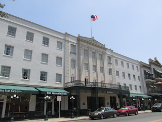
Take a short half block stroll just to the south of the Alamo in San Antonio Texas and you'll come to the Menger Hotel, a hotel built by German immigrant William Menger who moved to Texas at the age of twenty in the 1840's. His first residence in Texas was a San Antonio boarding house operated by Mary Guenther. William Menger would go on to build a brewery with a man named Charles Degen in 1856 and a hotel which was essentially across the street from the Alamo. Menger by trade was a barrel maker and Degen a brewmaster.

menger hotel san antonio
Menger Hotel, San Antonio, TX
The Menger Hotel, opened in 1859 on the site of the old Menger Brewery, the first brewery in Texas, was said by some to be "the finest hotel west of the Mississippi River". Indeed, in 1859 there weren't a great number of fine hotels west of the Mississippi River. Menger's idea for building the hotel arose from the many visitors he had to his brewery. At the time he operated a boarding house and decided to expand it into a full fledged hotel. Menger's new hotel brought to Texas it's first truly sophisticated frontier hotel. The Menger opened just twenty-three years after the historic battle at the Alamo.

Interesting Facts About San Antonio's Menger Hotel

San Antonio's Menger Hotel had many notable guests in it's earlier years, such as Ulysses S. Grant and Robert E. Lee. The hotels guests over the years included presidents of which included Theodore Roosevelt who, prior to his presidential years, used the Menger Hotel facilities to recruit Rough Riders for his campaign in Cuba during the Spanish American War.The Menger Hotel was also where Richard King, founder of the massive King Ranch in southeast Texas died in 1885.

The invention of barbed wire also had a Menger Hotel connection. It's been said that the first public demonstration of barbed wire took place outside of the hotel. Impressed prospects then went inside the hotel to place their orders. As we know, barbed wire changed the ranching industry for ever.


menger
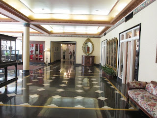
Menger Hotel lobby
The Menger Hotel in the Twentieth Century

During the twentieth century a few of the hotel's notable guests included the baseball star Babe Ruth, the Hollywood celebrity Mae West and the famous businessman Cornelius Vanderbilt. Also visits from Dwight D. Eisenhower and Oscar Wilde.

Since it's beginning in 1859 the Menger Hotel has undergone restorations and enlargements. Today the historic Texas hotel is comprised of 316 rooms and suites and claims to have San Antonio's largest heated swimming pool.

The Menger Hotel was sold to Texas businessman William Lewis Moody Jr. in 1920. At the time of the acquisition Moody owned other hotels operating under the National Hotel Company name. This hotel company also operated two hotels in Galveston Texas. During Moody's father's lifetime he had entered the banking business and the cotton business. Both were successful endeavors.

menger hotel texas
Central garden area
When Moody Jr's father died in 1920 he inherited the  W. L. Moody and Company, Bankers, and the W. L. Moody Cotton Company. As a side note, Moody Sr. acquired the National Bank of Texas, which became the W. L. Moody Bank. In 1907 Moody opened the City National Bank, which later became Moody National Bank.

When Moody Jr. purchased the Menger Hotel in 1920 he had quite a lot of commercial interests throughout the state of Texas. William Lewis Moody Jr. was a Democrat and for years supported and had close ties with William Jennings Bryan.

Additional Western Trips photo articles of San Antonio Texas sites to see areon the links below...

The San Antonio Spanish Missions

The Guenther House and Pioneer Flour Mill

A World Class Austin Texas Museum

Visit the Menger Hotel

The Menger Hotel today is one of the finest hotels in San Antonio Texas. Located adjacent to the Alamo historical site, if you're not staying at the Menger you should at least try make a short stop at the hotel and see how beautifully restored it is.

I'm sure you've heard about some of the old historic hotels that have reputations as being haunted. Add the Menger Hotel to this list. Some say that the Menger is the most haunted hotel in Texas. Included in the hauntings are reportedly Texas rancher Richard King who passed away at the Menger and a maid at the hotel who was murdered by her husband. King's funeral was held in the parlor of the Menger Hotel.


historic sites san antonio texas
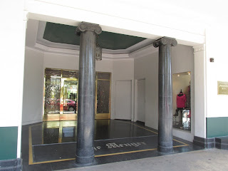
Menger Hotel front entrance
Hotel guests over the decades have reported strange occurrences including sudden coldness, odd smells and apparitions appearing in mirrors. Guests visiting the Richard King suite have reported pages flipping on a tabled book for no apparent reason. Some of the sightings reported of King today has him trying to enter his old room. Claims of his sighting have been reported by both hotel guests and employees.

The maid who was murdered at the hotel, Sallie White, is said to have been seen in the hallways of the hotel's Victorian wing. People have reported seeing her in a long grey skirt carrying towels which are never delivered. The uniform the maid has been seeing wearing is of the style used during the late 1800's. 

The Menger Hotel is located  in downtown San Antonio Texas at 204 Alamo Plaza. The Menger Hotel is also just one block from San Antonio's popular River Walk which is a great place for a stroll and a ride on the picturesque river.

A good book on the subject of San Antonio's Menger Hotel is The History and Mystery of the Menger Hotel by author Docia Schultz Williams.

(Article and photos copyright 2013 Western Trips)

Saturday, August 10, 2013

Donner Summit and Historic Central Pacific Railroad Sites


Chinese laborers in early California had built portions of the California Central Railroad from Sacramento to Marysville as well as the San Jose Railway. Their next project would be far from ordinary and quite historic.

old town sacramento california
Old Sacramento California
The biggest railroad project by far however would be their work through the Sierra Nevada as part of building the nation's first transcontinental railroad. Chinese work crews performed the work that made this route possible.

This was dangerous work for the Central Pacific Railroad involving hanging by ropes over cliffs, boring holes in granite walls and placing explosives in the holes. Add to this the high mountain environment in winter. Quite dangerous work in the harshest of conditions.

While the eastern portion of the transcontinental railroad had mountainous sections, nothing along it's route compared to laying rails over Donner Summit in the Sierra Nevada range. Workers often  lived in canvas tents along the rail grade. In the mountains workers often lived in wooden bunkhouses that helped to protect against the elements.

The earliest Chinese arrived in California in large numbers during the California Gold Rush days. Over 20,000 immigrants arrived during 1851 and 1852. For about twenty years afterward, about 8,000 Chinese immigrants arrived annually.

The work ethic of the Chinese impressed James Strobridge, the foreman of construction, as did their willingness to do the dangerous work of blasting areas for track in the treacherous Sierra Nevada, an effort that cost some Chinese laborers their lives. Chinese workers even helped lay a record ten miles of track in just twelve hours, shortly before the railroad was completed. This represented a tremendous accomplishment.

donner summit
High Sierra Nevada looking toward Donner Summit
In addition to the often hazardous working conditions, there was also antagonism toward these workers from European immigrants and many Californians in general. Chinese employees received wages of $27 and then $30 a month, minus the cost of food and board. This was at a time when Irishmen were paid $35 per month, with board provided.

Visit Historic Sites Along the Central Pacific Route
 

The book, Rails, Tales, and Trails is a guide to the historic sites of the Central Pacific Railroad, built by hand in the 1860s. The part of the book featured in this article talks about the Tunnels at Donner Summit. Rails, Tales, and Trails will tell you what you need to know for a self guided trip to the historic sites of the Central Pacific Railroad, built by hand in the 1860s. 


For more information about this book and the accompanying award winning film visit website www.transcoshow.com
 
The following excerpt from Rails, Tales, and Trails gives you directions for a self-guided tour to view the work by the California Chinese in building the Central Pacific railroad at Donner Summit.

The tunnels at Donner Summit

Elevation, 7,100 feet

From Rainbow Lodge take Highway 40 east, or go back to I-80 and exit at Soda Springs, it’s about 5 miles to the summit. Drive to the Rainbow Bridge Donner Lake overlook and park there or park on the side of Highway 40.

It’s not the Great Wall of China here but you will find the Chinese wall, actually two walls built to hold the trains that crossed the mountains for more than a century. A plaque commemorates the work of the Chinese who blasted and scraped the tunnels through the mountain and built this wall that held the heavy train loads through the 1990s.

China Wall of the Sierra Marker

“Charles Crocker, Construction Chief of the Central Pacific Railroad (CPRR), contracted for a workforce of approximately 12,000 Chinese laborers to push the CPRR tracks over its Trans-Sierra Crossing on its race east to a meet with the Union Pacific at Promontory, Utah Territory. A railroad retaining wall and fill, constructed of Sierra granite, stand silently above on the pass as a lasting monument to the Asian “Master Builders” who left an indelible mark on the history of California and the West.”

"Initially the Big Four resisted hiring Chinese, but soon discovered the Chinese proved to be quick learners and excellent workers. Samuel Montague, the chief construction engineer reported that “some distrust was at first felt regarding capacity of this class for the services required but the experiment has proved eminently successful. They are faithful and industrious. Many of them are becoming very expert in drilling, blasting and other departments of rock work.”

Stanford, in a report to President Andrew Johnson said “as a class they are quiet, peaceable, patient, industrious and economical. “ There was no doubt Chinese workers had the right stuff and literally “made the grade” for the Central Pacific Railroad. The Chinese, using only picks and shovels, would sculpt the grade. Excavated dirt and rock were loaded into small carts and moved to the side or used as fill to construct a trestle. White workers would lay in the heavy rail, which were 25-feet long and weighed 560 pounds per rail. Workers made around $35 a month, paid in gold coin, not the less-desired paper greenbacks. The wages were good money compared to a Union private’s pay of $13 a month. 

Many Chinese stayed with the Central Pacific and Southern Pacific Railroads after the completion of the transcontinental railroad in 1869, and helped build modern California".

california state railroad museum
Visit Many Historic Sites Along the Old Central Pacific Route

There are many historic sites to visit along the old Central Pacific Route. The link below will take you to our article describing a self-guided tour upwards from Auburn California.
Visit the fascinating California State Railroad Museum in Old Town Sacramento. This is probably the world's largest railroad museum under one roof. Here you'll see vintage locomotives and rail cars, artifacts and photographs of the building of the Central Pacific Railroad over Donner Summit and many additional unique exhibits.

See our Western Trips articles San Diego's Oldest Building in Old Town... "Driving California State Route 49" and The San Diego Zoo, A Must Trip Stop 

(Article and photos copyright Western Trips. Rails, Tales, and Trails book excerpt copyright Nimbus Marketing)


View Larger Map

Thursday, August 8, 2013

Longhorn Caverns of Texas


If you're looking for one of the most interesting and unique parks in the state of Texas, make a note of Longhorn Caverns State Park. This fascinating site is in the middle of the scenic Texas Hill Country in Burnet County.

longhorn caverns state park
Longhorn Caverns State Park Visitors Center
Opened to the public in 1938, the land at Longhorn Caverns was purchased by the federal government from private owners in the mid 1930's. The structures and roads built there were part of the Civilian Conservation Corp efforts during the Great Depression.

 If you're familiar with our National Parks you'll know that the CCC was involved in projects at many of them. Company 854 of the CCC was the group that made the site of Longhorn Caverns into a state park. The pay during this period was one dollar per day and the work was hard.

While the CCC worked at the site during the summer it was naturally much cooler down in the caverns. In one way working underground had it's advantages over working on roadways where the heat could reach over 100 degrees. By the same token, working underground could and would lead to back problems for many of the workers. Long stretches of the cave would force one to work hunched over for long periods.


limestone caverns
Limestone formations
The Stories of Longhorn Caverns

The caverns, first discovered by Anglos in the mid 1800's, actually have quite an interesting history outside of it's geologic formation.

Indians who first inhabited the caverns were said to have kidnapped people and held them for ransom in the caverns. One story has the famed Texas Rangers actually lowering themselves into the caverns by rope and freeing hostages after a fierce fight.

The Confederates were said to have used Longhorn Caverns as a place to manufacture gunpowder during the Civil War.The caverns are the home to bats and bat guano was used to make gunpowder.

It's said that the infamous Texas outlaw Sam Bass used the cavern as a hideout. Among other things Bass was known as a train robber. Visit the Longhorn Caverns today and you'll be told that the underground caves contain a hidden fortune that to this day has not been located. While there is no direct evidence that Sam Bass ever visited the cave, the story circulating was that some $2 million was stashed there.

limestone formations
Beautiful formations on high ceiling
During the 1920's the caverns were used as a speakeasy.In addition to this, entertainers would play music throughout the night. The speakeasy was also a dance hall. This subterranean speakeasy operated when the land and caverns were owned privately. A natural advantage for the speakeasy was the fact that the temperature inside the caverns stays at 68 degrees Fahrenheit all year long. This was a great advantage during those 100 degree plus days during a Texas summer and before air conditioning. While touring the caverns today you'll see stages that were set up for entertaining almost one hundred years ago.

 Longhorn Caverns was also used as a bomb shelter during the Cold War days of the 1960's. It was said that President Johnson who spent time on his nearby ranch in Stonewall Texas could have been relocated there during a nuclear conflict. The Longhorn Caverns were stocked with months worth of supplies during this time. The limestone rock of the caverns is said to provide added protection against radiation fallout. 


longhorn caverns observation tower
Park Observation Tower
Longhorn Caverns State Park Observation Tower and Hiking Trails

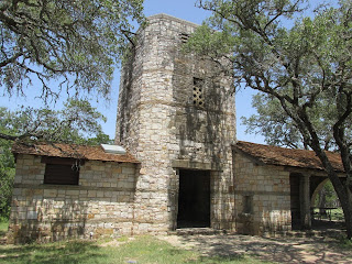
During the Depression, the Civilian Conservation Corps  made many improvements to the park. With great workmanship, they used native limestone and timber to construct buildings, retaining walls, and an observation tower. Climb the iron spiral staircase to the top of the tower and you'll have a sweeping view of the scenic Texas Hill Country. Other buildings constructed by the CCC during the 1930's include an administrative building that is now used for exhibits, a water tower, a cabin and a formal entrance to the caverns which is referred to as the Sam Bass Entrance.

You'll also want to take advantage of the hiking trails at the park. The Backbone Ridge Trail gets its name from Backbone Mountain, where the cavern is located.

See other Texas Hill Country Western Trips photo articles on the links shown below. 

The Nimitz Pacific War Museum in Fredericksburg Texas

The Famous Driskill Hotel in Austin Texas

The Lyndon B. Johnson National Historical Park


longhorn caverns state park buildings
Administration Bldg built by the CCC
Visiting Longhorn Caverns State Park

Longhorn Caverns State Park is located in Burnet County Texas. This is about 63 miles northwest of Austin and about 10 miles north of Marble Falls. Longhorn Caverns is on Park Road 4 accessed to the west off of U.S. Hwy 281 and north of Marble Falls.

The park is open 363 days per year, closing only on Christmas Eve and Christmas Day.This is a fun and educational trip perfect for the entire family.

(Article and photos copyright 2013 Western Trips)


View Larger Map

Tuesday, August 6, 2013

The Old Red Museum of Dallas Texas


old red museum dallas texas
The Old Red Museum
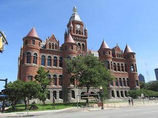
This article is about The Old Red Museum of Dallas which is located in downtown Dallas Texas. The museum is located in a beautifully restored building, built in 1892, that was the Dallas County Courthouse until 1966. Today, The Old Red Museum is an excellent addition to your Dallas Texas trip planner and a great place to learn how this city grew from one man's 1841 settlement to a major metropolitan area of the twenty-first century.

The Old Red Museum

The building is of red sandstone in a Richardsonian Romanesque style of architecture. The building was known locally as the Old Red Courthouse located at the southwest corner of Commerce and Houston Streets. The old courthouse is on the National Register of Historic Places.

The Old Red Museum is on the first floor of the Old Red Courthouse and exhibits the evolution of Dallas. Four permanent exhibits detail the history of Dallas Texas.

The Children’s Education Center within the museum offers a hands on and interactive experience for kids, and the museum also rotates a series of special exhibits that celebrate unique aspects of Dallas art and history.

old dallas county courthouse
Richardsonian Romanesque Architecture
Founded During the Days of the Republic of Texas

Dallas Texas was founded in 1841. John Neely Bryan from Arkansas built a log cabin in 1841 near a river and called the settlement Dallas. The river is what today is the Trinity floodplain and had existing trails made by the Native American Caddo tribe. The place along the trinity River that Bryan established his outpost was known as the White Rock Crossing. The crossing was considered easy for wagons before ferry service and bridges were erected.

Bryan's settlement would become a trading post. Like some other early settlement, one person might serve several functions. In the case of John Neely Bryan, he served as Dallas' first postmaster, store owner and ferry boat operator. In 1844 a plan was laid out detailing several city blocks that would one day become downtown Dallas Texas.This was at the time of the Republic of Texas which would then be annexed by the United States in 1845 at the time of the Mexican-American War. Dallas would go on to be incorporated in 1851.

The story of how Dallas was named Dallas has a few versions. One version has it named from a naming contest in 1842. A second version says that it may have been named after an 1842 settler named Joseph Dallas. Another is that it was named after a friend of John Neely Bryan. Yet another version has the settlement named after a naval Commodore and yet another after a U.S. Secretary of the Treasury. It has never been concluded exactly which is the official or real version however one of them obviously is.


richardsonian romanesque architecture
Old Dallas County Texas Courthouse
Not a seaport like the Houston-Galveston area of Texas, Dallas grew from the oil and cotton industries as well as farming. The city grew even further because of the many rail lines that crossed it as well as the many Interstate Highways that eventually converge from every direction.

Modern Day Dallas

While Dallas grew because of cotton and oil, the city today is a top ten American city and is generally referred to as the Dallas-Fort Worth Metroplex. Fort Worth was established eight years after Dallas in 1849 as a military fort overlooking the Trinity River and was named after major General William Jenkins Worth. Fort Worth would become famous for it's stockyards and later for it's oil industry. Fort Worth was located along the famous Chisholm Trail that led from southern Texas up to the rail stops in Kansas. The Texas and Pacific Railway built into Fort Worth in 1876 and made the area a famous cattle town.

The real growth of Dallas was a result of World War Two when many defense related companies called Dallas home. One of these was Collins Radio. As the decades rolled one, telecommunications and other technology companies also sprung up which has continued to this day. As a result, Dallas Texas has built a very diverse business base and is one of the most growing metropolitan areas in the U.S.

Below are links to additional Western Trips photo articles about Dallas area sites you'll enjoy.

The Perot Museum of Nature and Science

Interurban Electric Railway Museum


dealey plaza dallas texas
Dealey Plaza and old Schoolbook Depository Bldg
Visiting The Old Red Museum

The Old Red Museum is located in the heart of downtown Dallas Texas. It is available for both individual and group tours and is currently open 9A-5P daily.

Because The Old red Museum is located in the heart of Dallas, there's several other interesting sites to see nearby.  The museum is adjacent to the JFK Memorial and Dealey Plaza, a National Historic Landmark District. It is also across the street from a replica of Dallas founder John Neely Bryan’s cabin and just a block south of The Sixth Floor Museum and the historic West End of Dallas. All of these sites are in easy walking distance to the others.

(Article and photos copyright 2013 Western Trips)


View Larger Map

Friday, August 2, 2013

Historic Schoolhouses


Western Trips made a visit to a couple of very interesting historic schoolhouses on display in the western U.S. One of these old schoolhouses is on display in Santa Fe New Mexico and the other in Indio California, just a few miles east of Palm Springs. Both of these displays are among other historic artifacts and both sites make excellent additions to any vacation planner.

raton new mexico schoolhouse
Old Raton New Mexico schoolhouse
School classrooms back in the early part of the twentieth century and those even earlier back in the 1800's were quite a bit different from what we're used to today. In fact, some of the schoolhouses in the 1800's on the western frontier were one room structures where often, because of the small area, a single desk and seat would be occupied by two students.One small schoolhouse would often times serve all grades, K through 8.

The Santa Fe New Mexico Schoolhouse

The schoolhouse shown in the photos was at one time located in Raton New Mexico in the northeastern part of the state near the Colorado border. It is a two room structure. The schoolhouse was disassembled and relocated to El rancho Las Golondrinas, a fascinating 200 acre outdoor living museum. Several scenes from Hollywood movies have been filmed at this location over the years. Food grown today at this historic ranch site is donated to the Food Bank of New Mexico, which provides food for pantries.This outdoor museum also features a gristmill, blacksmith shop, church and many other interesting structures that were part of the Spanish occupation of the area.

las
Raton schoolhouse classroom
This particular schoolhouse is a small structure with a room adjacent to the classroom where the teacher lived. This is also the first schoolhouse built in Raton New Mexico which was along a segment of the old Santa Fe Trail as well as a stop for the old Atchison Topeka and Santa Fe Railroad.

The old Raton New Mexico schoolhouse was one of those where students did share a desk and a seat. It's quite a historic structure which fortunately was saved from destruction by having it moved to El Rancho Las Golondrinas.

Indio California One Room Schoolhouse

The old schoolhouse on display in Indio California was the second schoolhouse built the area. The schoolhouse is on the grounds of the Coachella Valley History Museum. This museum was established in 1965 by local residents and currently displays many artifacts from the period when Indio and the Coachella Valley was growing with the Southern Pacific Railroad building through the area. The Coachella Valley has a history of Date agriculture and the world's only Date Museum is located right next door to the schoolhouse. The schoolhouse was originally constructed on the site of what is now the Greyhound Bus depot. It was moved to the current site in 1999 and was beautifully restored.

coachella valley history museum
Old Indio CA schoolhouse
The structure also served as a hospital during the 1918 flu epidemic which spread throughout the United States and the world. It's estimated that about 50 million people died from this disease worldwide. More than 600,000 of those deaths were in the U.S. The 50 million number was thought to be more than double the amount of lives lost during World War One which had just ended.

During the 1930's the schoolhouse was moved to serve as a classroom for the Roosevelt School.
The restoration you see today takes the schoolhouse back to the year of 1909 and what it looked like then.

The Indio one room schoolhouse served grades K-8. The building today is dedicated as a reminder to the future generations of the vital role education played in the formation of the present communities in the Coachella Valley.


1909 indio california schoolhouse
1909 school classroom
Links below are to two additional Western Trips photo articles you'll enjoy. Joshua Tree National Park is located just to the east/northeast of Indio California and is one of the unique of our National Parks.

Another quite unique site is Quartzite Arizona, east of Indio near the Colorado River and along Interstate 10. Here was once a busy mining area and also the final resting place of a man they referred to as Hi Jolly. Hi Jolly, who later went by the name of Philip Tedro, was an Ottoman citizen who came to America to help the U.S. Army with it's camel expeditions through the southwest during the late 1850's. Being located along Interstate 10, Quartzite is a fun historical stop while on an Arizona/California road trip.

A Hiking Trip to Joshua Tree National Park

Historic Quartzite Arizona

El Rancho Las Golondrinas is located about fifteen miles southwest of the Santa Fe plaza at 334 Los Pinos Road.

The Coachella Valley History Museum where the 1909 schoolhouse is located is at 82616 Miles Avenue, Indio California.


(Article and photos copyright 2013 Western Trips)