Western Trips

Friday, November 30, 2012

Visit San Antonio


If your western road trip takes you through the Lone Star State, San Antonio is a must stop. The list of things to do in San Antonio Texas is a large one. Visit San Antonio to enjoy a wide range of fun family activities.

:san
San Antonio's River Walk
This is one metropolitan area that offers a mix of old historic sites, terrific restaurants and hotels especially along the beautiful River Walk, championship golf courses and fun family theme parks. San Antonio is one of those vacation destinations that can fit into a weekend or an entire week. In addition to the historic sites, San Antonio offers Seaworld and the Fiesta Texas Theme Park.

In this article we want to point out some great tourist sites in San Antonio outside of the popular theme parks. Some you certainly have heard of and some perhaps not.

The Alamo and the River Walk

Many people connect San Antonio with the historic Alamo. The Alamo is surely one of the top tourist attractions in Texas and is located in the city center not far from the San Antonio River. Visiting the city itself is easy and signage directing you to the various sites is very good. The Alamo and the River Walk are only a few blocks apart and visiting both is a must. The River Walk attracts a lot of people and the best times to stroll along it usually are the morning or early evening.

alamo in san antonio
The Alamo
You'll see the sightseeing barges taking tourists along the river and if time permits this is something you'll definitely want to check out. San Antonio River Walk hotels offer a variety of rooms and prices and you'll want to check them out before you plan a trip.

The Alamo was the very first mission in the area. Years later a string of missions numbering five total would be built by the Spaniards southward along the San Antonio River. A tour of the Alamo and it's expansive grounds is a trip into history. The remaining Spanish missions stretch southward roughly along the San Antonio River.

See our Western Trips photo article on the San Jose Mission and directions to the San Antonio Missions National Historical Park.

Seeing San Antonio By Trolley

This is a one hour tour that takes you to the heart of San Antonio. Historic sites and cultural attractions are on the itinerary of this narrated trip. The trolley tour is an excellent way to see some good sites while at the same time learning about the history attached to them. A one hour tour is easy to fit into any trip itinerary.

majestic theater in san antonio
Majestic Theater
Three Historic Old Theaters in Downtown San Antonio

One interesting historic site on Houston Street in downtown San Antonio is the Majestic Theater. This theater was designed and built in 1929 for Karl Hoblitzelle's Interstate Theatres. The Majestic at one time was regarded as the largest theater in Texas and the second largest motion picture theater in the entire country. In 1975 the Majestic Theater was added to the National Register of Historic Places. The theater today is operated by the Majestic Foundation and is the venue for concerts and all types of performing arts entertainment.

The Empire Theater was created in 1890 from what was the Empire Opera House on this site dating back to 1879. It was operated as a family theater until 1899. In 1913 a new Empire Theater, the one seen now, was built and operated until 1978. The theatre was originally equipped with an electric lighting system and stage equipment for motion pictures and vaudeville. In 1988, the City of San Antonio bought the neglected theatre, and through the work of the Las Casas Foundation, funds were raised to restore the Empire to its original luster. The Empire was reopened in April 1998 as the Charline McCombs Empire Theatre and is owned by the city of San Antonio.

empire theater in san antonio texas
Empire Theater
Yet another historic San Antonio theater is the Texas Theater. The Texas Theater opened in 1926 for the Publix-Paramount chain. The theater was constructed in Spanish Colonial and Rococco style. It had a  terra-cotta facade, complete with columns and multicolored arches decorated with gilded medallions. The Texas Theater was one of San Antonio's finest movie houses of the 1920s, along with the Empire and later Majestic Theatre. Like many other theaters of it's kind  in the 1970's, the Texas Theater closed it's doors. The theater was razed in 1983 but fortunately for history's sake its facade was salvaged. The facade is now incorporated into the office building built on the site.

San Antonio's Historic Pioneer Flour Mill 

This is a stop in San Antonio that you do want to consider making. The old Pioneer Flour Mill and Guenther House is located in the King James area of San Antonio.

guenther house in san antonio
This mill was started by a German immigrant named Carl Hilmar Guenther who originally settled in the Texas Hill Country town of Fredericksburg.  The story about the Pioneer Flour Mill is a very interesting story about German immigration into frontier Texas. At the site is a wonderful museum within the Guenther House along with an award winning restaurant. Add to this beautiful gardened grounds. The museum now houses mill memorabilia including antique baking accessories, cookie cutters and anniversary Dresden china plates which were given to customers by the mill. The site address is 203 E. Guenther Street, San Antonio.

See our Western Trips article on the founding of Pioneer Flour Mill by Carl Guenther in 1851.

Visit San Antonio to enjoy the south Texas culture, it's long history, it's unique museums, it's family theme parks and it's beautiful Spanish and Victorian architecture.

(Photos from author's private collection)


View Larger Map

Wednesday, November 28, 2012

San Antonio Missions


Western Trips makes a visit to San Antonio Texas and the historic missions found there. In addition to the historic Alamo, there's plenty to be seen in San Antonio.

san antonio texas mission
San Jose Mission, San Antonio TX
The mission featured in these photos is Mission San Jose y San Miguel de Aguayo, mostly referred to as Mission San Jose. This was the second mission established along the San Antonio River valley of southern Texas. Mission San Jose was established after the building of the Alamo. The Alamo's official name was Mission San Antonio de Valero and is of course the historic mission where the famous Texas defenders held out against the Mexican Army in 1836.

Mission San Jose in Texas

Father Margil de Jesus, assigned to the Alamo, decided that another mission was needed in addition to the Alamo. The Alamo was becoming too overcrowded. The father asked for and received permission from the provincial governor to establish a second mission south of the Alamo Mission. Mission San Jose was named for both Saint Joseph and the Marqués de San Miguel de Aguayo who was the governor of the Province of Coahuila and Texas at that time.

texas mission church
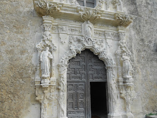
Mission church entrance
The founding ceremonies for this second mission took place in February of 1720. It's interesting to note that leaders of three Indian bands who desired to come into the mission were appointed governor, judge and sheriff of this new settlement named San Jose y San Miguel de Aguayo.

san jose mission in San Antonio
Spanish colonial Baroque architecture
Building of the Church

Today's visitors to San Antonio's Mission San Jose see a limestone church that was erected beginning in 1768. The statuary created on the church facade is amazing. You can just imagine the work and artisan skill needed to create such beautiful ornamentation. In 1768 there were thought to be about 350 Indians living on the mission grounds. The mission church  is thought to have been completed around 1782. When visiting today you'll quickly notice the very long walls extending around the mission grounds. The rooms you'll notice built inside of the walls generally housed the mission Indians.

The Spanish colonial Baroque architecture and especially the work on the church facade is remarkable as you might notice in these photos.The San Jose Mission was known as the "Queen of the Missions" as it served as a model for others.

Adjacent to the church main building is the convento. The convento was built to house both missionaries and visitors.The convento was a three story structure. What the visitor sees today is the exterior stonework. The story is that the people with the highest standing resided on the upper floors. Those without standing were housed on the first or ground floor.

Mission San Jose was named San Jose Mission National Historic Site in 1941 and was listed on the National Register in 1966.

mission san jose in Texas
Mission San Jose convento area
The Mission of the Mission

All Spanish Missions established in North America had one main purpose. That was to Christianize the Native population and turn them into tax paying subjects of the King of Spain. At the very same time the missions served as a symbol of Spanish sovereignty in the area. The Spanish military and the church worked relatively close. The same was true with the Spanish mission system of California which began in 1769 with the first mission erected in San Diego. The Spanish believed that in Christianizing the Indians peace would prevail. While this wasn't always the case, the missions did act as a stabilizing element.

As was the fate of the Spanish missions in California, when the Spaniards were ejected from North America by the Mexicans in the 1820's, the missions in Texas were also secularized. In February 1824 Mission San Jose ceased being a mission. The land was turned over to both the Mexican government and to the Indians living there. This mission and the others entered a period of neglect. Just as with the California missions, Mission San Jose deteriorated over the years. It wasn't until 1931 that the Franciscans returned to Mission San Jose and live there today. Today, the San Jose Mission in San Antonio is an active parish.

You'll find these additional related photo articles about the Spanish California missions interesting on our Western Trips site. The Sonoma Mission which was the last mission built in California. Also Mission San Juan Bautista and the Carmel Mission in Carmel California.

san jose mission
Rooms built within the mission wall
San Antonio Missions National Historical Park

Beginning in the 1920's, the San Antonio Conservation Society and the Federal Government plus other groups undertook to restore portions of the mission community. We are all fortunate for this as the San Jose Mission grounds serve as an excellent symbol of mission life during the period of Spanish rule in Texas. 

This large historical park which was established in 1978 preserves four of the five missions built in San Antonio Texas. The one mission which is not inside the park is the Alamo located in downtown San Antonio. The Alamo is operated by the Daughters of the Republic of Texas. When visiting the national park you'll be able to follow guided tours of the church and grounds by very knowledgeable park rangers.

To visit the San Antonio missions there is a driving route from downtown to Espada, the southernmost mission site in the park. The exact addresses of each mission are Mission Concepción, 807 Mission Road,
Mission San José, 6701 San Jose Drive, Mission San Juan, 9101 Graf Road, Mission Espada, 10040 Espada Road.

Driving to the missions from the downtown San Antonio area, go south on South St. Mary’s Street. About one mile south of downtown, after passing beneath railroad tracks, South St. Mary’s becomes Roosevelt Ave. Continue on Roosevelt 4 miles to a large stone structure on your left which is Mission San José. At the first stop light past the mission turn left onto New Napier Ave. Follow the signs into the parking lot. 

(Photos from author's private collection)

THE MISSIONS OF SAN ANTONIO VIDEO


Sunday, November 25, 2012

Conestoga Wagons


They looked graceful, they were called ships of inland commerce and they transported thousands of immigrants during the 1800's. The Conestoga Wagons played a very significant part in our nation's expansion. The Conestoga and then a hybrid of it was used by immigrants traversing the Overland Trail.

The Famous Conestoga

conestoga
Conestoga Wagon reenactment, 1961
The wagon's name denotes the region of Pennsylvania where they were first used in the early 1700's. The Conestoga Wagon was first used in the east carrying freight over the Allegheny Mountains. Later they and an offshoot of the Conestoga were used over the plains and the Rocky Mountains carrying settlers to California and Oregon. Traders on the old Santa Fe Trail liked the Conestoga wagon for both it's size and durability. The Santa Fe Trail was a heavy traveled freight route reaching from Missouri westward to Santa Fe. Often times the Conestoga wagons on the Santa Fe Trail pulled another wagon from behind.

The Construction of the Conestoga Wagon

The Conestoga wagon is often referred to as the "covered wagon". The covering which is the most distinctive trait on the Conestoga wagon was first made from hempen homespun and later of canvas.The wooden bottom of the wagon box was curved and rose at both ends. This design helped with the cargo while ascending and descending hills. The cargo would shift less easily and the tailgate would receive less strain. The wagon's wheels were usually rimed with iron to add to durability.

The wagon's average dimensions were 18 feet long, 11 feet high, and 4 feet wide. The wagon was pulled by horses or mules and was said to be able to carry about eight tons. The wagon might typically be pulled by up to eight horses or perhaps a dozen oxen or mules. Conestoga wagons were also known not to have drivers seats. The driver would generally walk alongside the wagon leading the front animal. The lead horse was usually the first on the left. There was often a braking system used which was generally a chain leading to the rear wheels. The chain could stop the wheel rotation causing a slide that would slow down the wagon.

prairie schooner photo
Prairie Schooner exhibit, Sutters Fort, Sacramento CA
The Conestoga Horse

The Conestoga Wagon actually had it's own breed of horse developed during the 18th and 19th centuries. These were the Conestoga Horses, bred to pull the typical heavy loads of the Conestoga's. The horses were first bred in Lancaster County Pennsylvania by Mennonite German settlers. This may certainly the only time in history that a special breed of horse was developed for one single commercial purpose. A Conestoga horse could be as large as seventeen hands. The breed is now extinct. The famous wagons lasted in the public's imagination much longer than the horses bred to pull them. The Conestoga horse today can only be seen in artwork from the era.

The Prairie Schooner

Essentially, the "prairie schooner" was a smaller Conestoga wagon. In modern day times it would be a small SUV as compared to a Chevy Suburban. The Conestoga's size alone made crossing the Rocky Mountains quite difficult. The size of the Conestoga killed oxen halfway through the trip west.

wagon train
1912 Pioneer reenactment
The immigrants were resourceful and came up with an alternative. The prairie schooner was basically a half size Conestoga. The prairie schooner was typically about four feet wide and ten to twelve feet long. This hybrid wagon weighed about 1300 pounds and could be easily disassembled. Everything the pioneer needed to cross rivers and certain mountain passes. The wagon bed usually was two to three feet deep. The front wheels were typically 44 inches in diameter and the rear wheels about 50 inches. The smaller front wheels allowed for sharper turns. Compared to the Conestoga wagon the prairie schooner had a relatively flat bottom.

The prairie schooner covering was often called the "bonnet". The covering was held securely to the wagon frame by hardwood bows. As far as springs were concerned, the prairie schooner usually had one set, under the drivers seat. The story is that the springs helped make the seat a bit more usable but by no means comfortable.

Probably one of the biggest misconceptions regarding the prairie schooner was that it was pulled by horses. In reality it was pulled by teams of oxen. Oxen were considered stronger than horses for heavy loads, endured longer, and their water needs were less. Something particularly important over the western desert region.

old west wind wagon
Old West Wind Wagon
It's also noted that some travelers on the Oregon and California Trails utilized wagons somewhat smaller than the prairie schooners. Some of these were simple ranch wagons with a covering. Although they served the purpose they were not nearly as sturdy as the prairie schooner and provided less shelter.

Three additional photo articles on Western Trips you'll find interesting are Oregon City Oregon, the official end of the Oregon Trail... Independence Missouri, the start of the Overland and Oregon Trail and Peppard's Wind Wagon, a way to travel westward by wind power alone. The photo left shows one variety of the Wind Wagon.

See the Conestoga Wagons and the Prairie Schooners

Among the select museums and historic sites where you can view the prairie schooners and the Conestoga wagons are the Virginia Museum of Transportation in Roanoke Virginia...Sutters Fort in Sacramento California...Fort Union in northeastern New Mexico about halfway between Las Vegas and Raton...The Conestoga Area Historical Society in Conestoga Pennsylvania...the Frontiers Trail Museum in Independence Missouri...The National Museum of American History in Washington D.C. and the North Carolina Transportation Museum in Spencer North Carolina.


OLD WEST COVERED WAGONS VIDEO


Wagon Train Reenactments

For those wishing to attend a real wagon train reenactment, check out the Highway 50 Association which conducts an annual wagon train, usually in June, between Nevada and California. The wagon train typically begins in the lake Tahoe area and travels westward into California. Their website is www.hwy50wagontrain.com

Two excellent reference books on frontier covered wagons are  Daily Life in a Covered Wagon by author Paul Erickson and Conestoga Wagons by Richard Ammon and Bill Farnsworth.

(Sutters Fort covered wagon photo from author's collection. Remaining photos from the public domain)

Thursday, November 22, 2012

Fun Things To Do In Texas


You may very well want to add visiting Waco to your list of fun things to do in Texas. You'll find some very historic and fun  stops to add to your Texas trip planner.

dr pepper museum
Dr Pepper Museum, Waco TX
Located along Interstate 35 about 100 miles south of Dallas and about the same distance north of Austin, Waco Texas, situated along the Brazos River, is the home of the Texas Rangers Hall of Fame and Museum, the Dr Pepper Museum and the beautiful 1902 McLennan County Courthouse. Waco's settlement goes back during Texas' pioneer days. At one time, the Brazos River was quite active with steamboats and played an important role during the American Civil War.

Waco Texas is located in McLennan County and was founded in 1849. This would have been just after the conclusion of the Mexican American War and after the frontier line expanded further west. The first house in Waco was built in March of 1849. It was a simple double log cabin structure built on a bluff.

The Dr Pepper Museum

The Dr Pepper Museum and Free Enterprise Institute is located in downtown Waco at 300 S. Fifth Street. What some might not realize is that the soft drink Dr Pepper was invented at Morrison's Old Corner Drug Store in Waco. A pharmacist who spent much of his time filing prescriptions also spent time working on the formula that one day would become Dr Pepper. The actual inventor of the Dr Pepper formula is thought to be a young pharmacist by the name of Charles Alderton. The story is that Alderton set out to replicate the smell of the drug store which had a fruit syrup aroma. Eventually Alderton created a mixture to his liking and asked the store owner, Morrison, to give it a taste. Morrison enjoyed the flavor of the drink and eventually the concoction was sold to customers at the store's soda fountain beginning in 1885.

dr pepper museum in waco texas
Dr Pepper Museum and Free Enterprise Institute
The drinks popularity increased to the point that other drug stores in Waco was ordering the syrup from Morrison. Meanwhile, Alderton wasn't interested in pursuing the soda any further and returned to being a full time pharmacist. Morrison and a chemist named Robert S. Lazenby formed a partnership in 1891 that would eventually be named the Dr Pepper Company. After years of growth, the Dr Pepper Company relocated to Dallas Texas in 1923.

As far as how the soda got it's name, nobody knows for sure. What is known is that Morrison himself is responsible for coming up with the name Dr Pepper. Past that, there are several different stories as to how he came by the name.

Today, the Dr Pepper Museum and Free Enterprise Institute is a fun place to visit while traveling though central Texas. Among the exhibits is a replica of Morrison's Old Corner Drug Store and soda fountain, a rural general store with a 1920's pick up truck and a variety of vintage Dr Pepper bottles, cans and signage.

The Free Enterprise Institute was started in 1997 as a way for young students to get acquainted with marketing. The students use the soft drink industry as a model and from there go on to create marketing programs, logos, slogans, etc. The institute offer students a real hands on approach to marketing a product from scratch.

texas rangers museum in waco texas
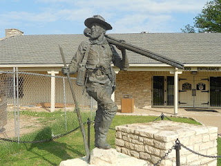
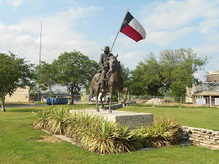
Texas Rangers Museum
The Texas Rangers Hall of Fame and Museum

The Texas Rangers Hall of Fame and Museum is located on the east side of Interstate 35 and just north of the Baylor University campus in Waco Texas. You'll find visiting this one of a kind museum among the fun things to do in Texas.

The Texas Rangers have a long history serving the Republic of Texas as well as the State of Texas. The Texas rangers have a storied history. From protecting settlers during the early republic days... fighting in the 1840's Mexican American War...Civil War battles on the side of the Confederacy...chasing outlaws and rustlers...the history of Texas in many ways is the history of the Texas Rangers. In 1997, the Texas state Legislature named the Texas Ranger Research Center as State-designated official repository for archives and artifacts related to the Texas Rangers.

texas rangers hall of fame and museum
TX Rangers Hall of Fame and Museum
The Texas Rangers Hall of Fame and Museum is the perfect place to learn more about their heritage. Exhibits include artifacts and photos plus an excellent research library. See historic Ranger badges... learn about the thirty Texas Rangers who gave their lives up in the line of duty... read historic case file information... see a genuine 1928 Thompson Machine Gun...view a collection of Texas Highway Patrol badges dating back to the 1930's..special Ranger handguns... A Lone Ranger Collection and much much more.

McLennan County Courthouse

Located in the western area of downtown Waco, the McLennan County Courthouse's architecture was said to be inspired by St. Peter's Cathedral in Rome Italy. Funds for the courthouse were raised by a $250,000 bond offering in 1900. This Texas Historic Landmark designed in 1902 by architect J. Riely Gordon and constructed by Tom Lovell was built in the Classical Revival style. with Beaux Arts influences. You'll find that Texas courthouses were built in a variety of styles, some quite elegant. The McLennan County Courthouse stands out as very unique. The layout of the building with it's wings is very similar to that of the Texas State Capitol. Surmounting the lantern of the dome is a statue of Themis, the Greek personification of justice.

mclennan county texas courthouse
McLennan County Courthouse, Waco TX
The area of today's McLennan County was at one time a Mexican land grant given out in 1925. Indian raids and  their ongoing threat caused permanent settlement in Waco and much of the county to be delayed until the 1840's. McLennan County was established by the Texas state legislature in January 1850. The county was named for Neil McLennan, one of the areas early settlers.

Also, see our Western Trips photo articles about historic Salado Texas, halfway between Waco and Austin and the beautiful and historic Driskill Hotel in downtown Austin.


Visiting Waco

Waco Texas, being halfway between Dallas and Austin and along the busy Interstate 35 corridor, is sometimes easy to pass right through without stopping. If your Texas travel plans permit I think you'll find the attractions in Waco described in this photo article to be great additions to your Texas trip planner. There are plenty of fun things to do in Texas and visiting historic Waco is one of them.

(Photos from author's private collection)
View Larger Map

Wednesday, November 21, 2012

Steam Locomotive


Western Trips visits one of the most famous steam locomotives of the 1900's. The Santa Fe 5000 steam locomotive was one of the most unique and powerful railroad engines ever built. The Santa Fe 5000, also referred to as the Atchison Topeka & Santa Fe Railroad 5000, was built in 1930. The entire reason for it's design and construction was to build a heavy freight locomotive with the traction power to pull extremely heavy loads and to pull them in the topography of the western U.S.

santa fe 5000 steam locomotive
Santa Fe 5000
On Display in Amarillo Texas

Today, this famous locomotive is on static display at the Santa Fe Park just outside downtown Amarillo Texas.

Fortunately for railroad buffs and the general public, this particular steam locomotive was given to the city of Amarillo Texas in 1957 after it had been taken out of service in 1953. This locomotive served the At & SF Railroad for some twenty-three years. During that time, the AT & SF 5000 traveled over 1,750,000 miles. The locomotive cost about $135,000 to build in 1930 dollars. It's thought that there were nine of these 5000 Series locomotives which were saved from scrapping. All of the steam locomotives operating on the Atchison Topeka & Santa Fe Railroad were removed from operation during the 1950's after the diesels were perfected.

The Santa Fe steam locomotive on display in Amarillo Texas is on the National Register of Historic Places.


atchison topeka and santa fe steam locomotive
AT & SF Railroad 5000 locomotive
AT & SF Railroad Number 5000 Steam Locomotive Specs

Following are specifications of this particular Santa Fe 5000 engine which was nicknamed the " Madam Queen".

  • The Santa Fe 5000 was configured as a 2-10-4 Texas Class. This was the only engine of this particular class.
  • Driving wheel diameter of 69 inches.
  • Cylinders measuring30 inch bore and 34 inch stroke.
  • Boiler pressure of 300 psi.
  • 93,000 lbs tractive force.
  • Burned coal from 1930-1940 and fuel oil from 1940 to the present time.
  • Locomotive weight of 502,600 lbs with the tender weighing 396,306 lbs. Total weight of 898,906 lbs.
  • Length of 108 feet, 5 1/4 inches.
  • Average speed of 60 MPH.

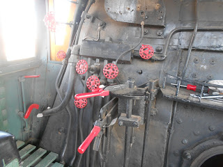
steam locomotive interior
Santa Fe 5000 cab controls
The History of the 5000 Series Steam Locomotives

The Santa Fe 5000, while being built by the Baldwin Locomotive Works, was designed by people working for the AT & SF Railroad. No alterations were made during the production of this steam locomotive without the consent of the design group.

Railroad buffs will remember that the first steam locomotives were named after railroad board members and/or owners. A good example of this is with the "Governor Stanford",  the first locomotive ordered by the Central Pacific Railroad in California. The Governor Stanford is on permanent display at the California State Railroad Museum in Old Town Sacramento. Eventually, the Atchison Topeka & Santa Fe along with other railroads adopted a number system to identify their locomotives. Generally, the higher the number, the more advanced the locomotive.

During the production of the 5000 Series steam locomotives through the 1930's, some modifications were made  after the original was built. Modifications were made to this original model as well. The most significant change seen in the 500 series locomotives, aside from being converted to fuel oil power, was in the driving wheel diameter.  Eventually the 2-10-4 configurations of the 5000 Series had a 72 inch wheel diameter. Other changes had to do with a larger square tender car which required the locomotive cab roof to be modified.

The 5000 series steam locomotive proved to be a success for a variety of reasons. It was documented during testing to be able to carry 15 percent more weight in nine percent less time. The locomotive also burned less coal per ton.

The Santa Fe 5000 featured in this article was built during the start of the Great Depression. The result was that other 2-10-4 configurations weren't built and put into service until 1938. This was even though the concept of the 2-10-4 was considered as far back as 1919. Thirty-five of the 5000 steam locomotives were ordered by the AT & SF starting in 1938. Had it not been for the financial depression more of these designs would certainly have been built prior to 1938.

See our Western Trips related photo articles on the Donner Pass Locomotive...the Fred Harvey Cochiti AT & SF Dining Car...and the Doodlebug Locomotive.

2-10-4 steam locomotive
Restoration of the Santa Fe 5000 Steam Locomotive

For years after the Atchison Topeka and Santa Fe Railroad gave this steam locomotive to the city of Amarillo it sat as it sat unattended. Finally, in 1992 restoration work was undertaken by volunteers. In 2002, the group was formed into the Railroad Artifact Preservation Society, a Texas non-profit organization. The Santa Fe 5000 was relocated to it's present site in 2005 at which time the group began work on cosmetic restoration. That restoration project itself took three years to complete. As a result of their dedication, expense and hard work, today, the old AT & SF 5000 is a marvelous display of one of the, if not THE, most powerful steam locomotive to run on America's freight railroad routes.


See the Santa Fe 5000

One of the first impressions you'll get when viewing the Santa Fe 5000 close up is it's seemingly enormous size. If you're in the Texas Panhandle area, a stop to see this locomotive is a fine addition to any road trip planner. The Santa Fe 5000 Steam Locomotive is located at Santa Fe Park in Amarillo Texas. The park is located at S. Buchanan Street at 2nd Avenue SE.

(Photos from author's private collection)

Friday, November 16, 2012

Cattle Trails

Western Trips takes a visit to the old Magdalena Trail and historic Route 60 through New Mexico. The Magdalena Trail may not be quite as well known as the cattle trails like the Goodnight-Loving Trail, the Chisholm Trail or the Great Western Trail that actually ran from the Rio Grande in Texas to the Canadian border. The Magdalena Trail had it's origins back to 1885 and this western cattle trail actually operated into the latter part of the twentieth century.

us highway 60 sign
Like with all western cattle trails, the railroad was very involved. The Magdalena Trail came into being when the Atchison Topeka & Santa Fe Railroad built a branch line west from Socorro New Mexico. Every old west cattle trail had it's terminus at a rail head. This was true with Abilene, Wichita and Dodge City Kansas. It was true with Las Vegas New Mexico, east of Santa Fe, and it was true with the old town of Magdalena New Mexico.

The Magdalena Trail

Ranchers from the vast area of western New Mexico and eastern Arizona started to drive their cattle and sheep to the railhead at Magdalena. Cattle trails were necessary simply to get your herd top market. The Magdalena Trail is also called the "Magdalena Stock Driveway". The designation of a "stock driveway" occurred in 1916. Essentially it was a designation of land by the government for allowing enough area for ranchers to drive their herd to the railheads. In certain places the driveway could extend five to ten miles in width so that there was ample forage for the herd. This land was open range. Forage was a big concern. Here is why.  Due to the large distances traveled by western cattle, at times ample forage was hard to find and as a result the cattle could arrive at the Magdalena railhead in poor condition. For the rancher this meant lower prices for his herd.

An interesting area you may want to explore is Datil Well where water wells were spaced about fifteen miles apart for use on the Old Magdalena Trail. Today, the area is the Datil Well Recreation Area Campground.


Well is named for the town of Datil, 1 mile to the west. This is the location of one of 15 water wells spaced 10 miles apart along the old Magdalena Cattle Trail.

The Magdalena Trail in the Twentieth Century
cattle drive in new mexico
Magdalena Cattle Drive

When the Texas cattle trails disappeared with the expansion of the railroad and with farming taking over much of the former grazing land, the Magdalena Trail continued in the west. Two sections of the Magdalena Trail merged in western New Mexico. One started near Springerville Arizona and the other near Reserve New Mexico to the south. Yet a third branch trail merged into the main trail starting near Winston New Mexico. All cattle and sheep along the Magdalena Stock Driveway then headed east to Magdalena and the AT & SF railhead. This historic Magdalena Stock Driveway was used annually, from 1885 through 1916 when the stock driveway was officially made into law. This historic Stock Driveway was used annually, from 1885 through 1916 when the driveway was officially designated by law. The peak year on the Magdalena Stock Driveway was 1919 when some 150,000 sheep and about 20,000 western cattle were moved . Generally cattle could be driven about ten miles a day and sheep five miles. The Magdalena Trail was continually used through 1971. The trail was the country's last regularly used western cattle trial.


us highway 60 map
US Hwy 60
The First Ocean to Ocean Highway

Long before the establishment of Route 66 from Chicago Illinois to Santa Monica California, there was an overland trail that extended from Santa Monica to Virginia Beach Virginia. The trail passed through New Mexico from Quemado to Clovis. Today, this is US Hwy 60 or Route 60. The entire length of the highway was 2,670 miles east to west. Route 60, just like Route 66, saw rerouting when the Interstate Highway System was built. The end result was that mileage was lost to the Interstates. Just like Route 66, you'll find signage where the original road is still used. In New Mexico, Route 60 is still fairly intact. It is in other states both east and west of New Mexico where major changes occurred.

Going from east to west in New Mexico, Route 60 today runs from Clovis, on the Texas border, to Interstate 25. You would then drive south on Interstate 25 for about 25 miles to Socorro. You would then pick up Route 60 again in Socorro and it runs westward to the Arizona border. The only interruption of US Hwy 60 in New Mexico is the short distance on Interstate 25. From Socorro New Mexico to Springerville Arizona, US Hwy 60 follows the same general route as the Magdalena Trail.

Three additional Western Trips photo articles you'll find interesting are the Great Western Trail .... the Red River Valley Museum and Doans Crossing on the Western Trail and Wild Horses and Cowboys.

fort sumner new mexico
Billy the Kid mural in Fort Sumner, NM
Driving Route 60 Through New Mexico

Taking a western road trip over today's Route 60 is like taking a trip into history. All along the route are historic towns, landmarks and National Historic Sites. You can compare it to a trip on Route 66 except in New Mexico Route 60 is essentially all intact.

Among the things to see on Route 60 include Clovis New Mexico and the vast BNSF Railroad yards. Fort Sumner New Mexico where Sheriff Pat Garrett shot Billy the Kid. This is the site of two good old west museums with plenty of interesting exhibits and the grave site of Billy the Kid.

West of Socorro you'll view the Magdalena Mountains. The eighteen mile long Magdalena Mountains are about twenty miles west of Socorro and offer great hiking trails. Most of the rocks along the eastern part of the range are volcanic. Some other sections of the Magdalena's that are not volcanic are considered good climbing sites.

In the town of Magdalena you'll want to take the walking tour. The town site has many historic buildings to explore including the old Magdalena Stockyards. The stockyards operated until 1971 when the Atchison Topeka and Santa Fe Railroad closed the rail line. You'll also want to check out the London Frontier Theatre Company which puts on summer performances. A great addition to your western road trip on Route 60.

new mexico scenery
A road trip through central New Mexico
About thirty-six miles west of Magdalena, Route 60 passes  a section of the Cibola National Forest and the Datil Mountains. This is one of the many sections of the Cibola National Forest which are found in central and western New Mexico. Some nearby good historic old towns to explore include Pie Town and Quemado New Mexico. Pie Town is the location of the of the very large antennas that are part of the Very Long Baseline Array of the National Radio Astronomy Observatory. The antennas start west of Socorro and extend westward. Quemado, in the high desert at about 7,200 feet, is another interesting stop near Pie Town on Route 60. When you stop at this unincorporated area be certain to check out "The Lightning Field". Created by American sculptor Walter De Maria, The Lightning Field is a work of Land Art situated in a remote area of western New Mexico outside of Quemado.

Route 60 offers a lot of interesting sites all throughout New Mexico. When you drive it west of Magdalena, the highway is a living history of the western cattle trail days. The route may be a good addition to your New Mexico trip planner.

(Billy the Kid Mural and central New Mexico photo from author's collection. Remainder of photos and images from the public domain)

LARGEST CATTLE RANCH: AMERICA'S HEARTLAND SERIES VIDEO


Wednesday, November 14, 2012

Passenger Trains


At the turn of the twentieth century there were passengers train service to, it seems, just about everywhere. Cities and towns of just about any reasonable size had some type of passenger train service. When the age of electric railways dawned after 1900, passenger trains increased greatly. This was the time prior to the National Highway System and train travel, whether long distance or short line was the primary way people got around.

danville california train depot
Danville CA SP Train Station, 1890's
The Museum of the San Ramon Valley

The Museum of the San Ramon Valley is located in Danville California at the corner of Railroad and Prospect Avenues. Danville is about a 22 mile drive east of Oakland California


The museum presents a wealth of information regarding the San Ramon Valley. Housed in the old railroad station of the Southern Pacific Railroad, each summer the museum puts together an excellent display of railroad history of the valley including the town of Danville. The station, today's museum, was built by the railroad on eight acres of land purchased from John Hartz. A hotel was constructed across the street on Railroad Avenue to provide accommodations to both railroad passengers and  SP train crews.

The Electric Trains and Danville California

The electric trains enabled efficient and dependable service for people who wanted to just travel to the next town or so up the line. Compared to the steam trains, the electric trains didn't fill the air with soot. Imagine a steam locomotive running through the center of a town. Imagine the smoke and soot put out by the boiler. The fact is, they did go through town and the SP steam locomotives operated at the same time as the electric trolleys during the first few decades of the 1900's. The electric trains were both cleaner and much quieter. This fact alone added to their immediate acceptance as a reliable interurban.

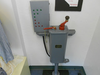
electric railcar speed control
Speed control mechanism for electric railways
One of the heaviest used electric spur lines ran a short distance from what was then a town called Saranap California south to Danville California. Today, Saranap is the the greater city of  Walnut Creek. This is in the San Francisco East Bay area east of the hills behind Oakland and Berkeley. During the early 1900's this was primarily an agricultural area. Today, it's a booming metropolis of towns and cities and freeways. The cities also serve as convenient bedroom communities to the greater San Francisco region.


Danville California was named after Daniel Inman who, along with his brother, purchased 10,000 acres of land in the area. This would have been the time of the California Gold Rush in the Sierra foothills to the east. The catalyst for the rail line down to Danville California came from the Oakland Antioch and Eastern Railway, an electric line, that ran from Oakland to Sacramento California. The line actually allowed passengers to travel straight through to San Francisco via the Key Line Ferry in Oakland. In Saranap, just outside today's Walnut Creek, a car was removed from the train and sent down the tracks to Alamo, Danville and further to  the site of Diablo Station at the foot of Mount Diablo.

electric trolley car
Early 1900's electric trolley
The Toonerville Trolley Passes Through the Center of Town

While the Southern Pacific Railroad and their steam locomotives came to Danville and the San Ramon Valley in 1891, the electric trains from the Oakland Antioch and Eastern came in 1914. This was the period when electric railroads in the U.S. were taking off. The car that served Danville from the main line in Saranap, about ten miles north,  had various names. It was at times referred to as The Alligator, The Dinky, The Riveter and The Toonerville Trolley. When the tracks were laid through the center of Danville in the early 1900's, it symbolized to many it's transition from a purely agricultural community to that of a growing town. Train car 1051, was sometimes called "The Toonerville Trolley" in reference to the comic strip of the era, "Toonerville Folks". In fact, the comic strip continued into the 1950's. The car that was used, 1051, was a converted baggage car made into an electric trolley. The trolley car and the Danville Branch rail line operated from 1914 to 1924.

After 1924, electric railways still had a future in Danville's Contra Costa County. Although not running to Danville, the Sacramento Northern served the county from 1929 to 1941. The Sacramento Northern was at that time the nation's longest interurban electric railroad. The Sacramento Northern was also the only interurban that employed a ferry boat to take the rail cars across Suisun Bay.

A Decade of Service 

In addition to the trolly's job of helping people get to their jobs in surrounding communities, the electric rail line also allowed city folk an easy way to visit the countryside. During the early 1900's, Mount Diablo just east of Danville was a very popular summer getaway for families form the big cities of San Francisco and Oakland. Many people passed through Danville on the summer weekends heading for Mount Diablo and the panoramic views seen from it's summit.

In addition to passenger service the electric trolley also hauled freight which helped the economies of the San Ramon Valley.  The Danville Branch Line operated all throughout World War One and carried workers from the San Ramon Valley all the way to the shipyards at Port Chicago to the north.

Three additional Western Trips photo articles you'll enjoy are the San Francisco Cable Cars...the Electric Streetcars of San Francisco and the old steam  Passenger Ferries of San Francisco Bay.

Another article you'll enjoy is a self-guided tour of the old railroad tracks that were built by the Central Pacific Railroad as part of the first transcontinental railroad. The following link will take you to Rails, Tales and Trails on our Western trips site.

toonerville trolley streetcar
Courtesy San Ramon Valley Museum
The End of the Line

Progress spelled the end of the Danville Branch of the Oakland Antioch and Eastern Railway. Roads were improving and buses and cars were more convenient. It's ironic that with today's heavy highway and freeway traffic and with the price of fuel, the electric railways have and still are making a dramatic comeback. The San Francisco bay Area today has the electric third rail BART system connecting most of the Bay Area and it's bedroom communities. Where BART currently does not operate, other electric train systems serve most of the other communities.

Another venue to further explore the electric railroad is located between San Francisco and Sacramento.In Solano County California you want to stop by the Western Railway Museum. In addition to a very large exhibit collection, the museum also features a ten mile ride on an electric railway car. The electric rail car ride follows the original historic main line of the Sacramento Northern Railway. The Western Railway Museum is located at 5848 State Highway 12, Suisun, CA. This is about 40 miles north/northeast of the San Francisco Bay Area. The most direct route is via Interstate 80 eastbound toward Sacramento.

(Control mechanism photo from author's private collection. Remainder of photos Courtesy of the San Ramon Valley Museum)

Sunday, November 11, 2012

Colt Handgun

Traveling around the western U.S. you'll come across many museums and other venues which display vintage Colt pistols and revolvers. The Colt handgun was the most widely use non-rifle weapon during the mid 1800's.Colt has a long history of firearm manufacturing and their products are identified with much of the history of the United States. Colt arguably manufactured some of the most popular revolvers used world wide. He likewise was considered the Henry Ford of the firearms industry in as much as he pioneered the gun assembly line made possible by the interchangeable parts. Below are some of the interesting Colt Revolvers with a brief description of each.

colt firearm factory
Colt Armory, 1857
Colt Firearms Collections Throughout the West

You might find it fun to add some of the frontier museums and venues to your western trip vacation planner. Many of these museums are in small towns and either are free to visit or have small admission fees. A good number of them are operated by local historical societies. You'll also find good Colt displays as several old western forts that now have become National Historic Sites. These venues showcase all types of frontier weapons and artifacts and are low cost ways to enjoy your western trip. At the end of this photo article I've listed some good stops that might fit into some of your future western travel plans.


Samuel Colt experienced a few business misfires prior to his development of the revolver patent in 1836. Nevertheless, the Colt handgun would achieve great fame. His selling to the military in the 1840's along with a several thousand gun order from the Texas Rangers during their Mexican and Comanche problems helped Colt establish himself as the top hand gun company of it's time. Samuel Colt himself would become one of the wealthiest people in the country.

1843 colt revolver
1843 Colt replica
The 1843 Colt Handgun 

This early 1843 Colt handgun, which began with Colt's 1836 patent for the revolving firearm, can be called among the guns that helped save Samuel Colt's company. One impediment to sales was the financial depression of the late 1830's going into the 1840's. In fact, it was these bad economic times in the U.S. that encouraged people to start heading west on the Overland Trail.

Colt ended up selling these 1843 models along with modified versions in great quantities to the federal government. Because of the amount of revolvers ordered, the government awarded Colt some subsidies. These style early pistols employed a mechanism that combined a single rifled barrel with a revolving chamber that held five or six shots. This design mechanism was the basis for the 1836 patent. Colt's US revolver patent gave him a monopoly on revolver manufacture all the way to 1857.

Prior to the 1840's the government didn't really see a need for the short barreled weapons. Rifles essentially ruled the day when it came to military warfare. They were considered more accurate and more powerful than a pistol and especially during battle.

This early Colt revolver was considered to be accurate to perhaps 40 yards if fired by an expert.


1851 navy colt revolver
Colt 1851 Navy .38 caliber revolver
The 1851 Colt Navy Revolver 

The 1851 Colt Navy Revolver was one of the highest selling Colt guns. The model was produced from 1851 to 1873. It was one of the most popular pistols used during the Civil War. Over 200,000 of these guns were produced at Colt's Hartford Connecticut plant.

These Colt firearms were percussion revolver chambered for both .38 or .44 caliber ball shot. These guns were often referred to as "Cap n Ball" guns. What was involved were percussion caps, black powder and an ammunition source. The 1851 Colt was favored by Union Army officers for several reasons. The gun was relatively light weight, had good accuracy and was easy to disassemble. In regards to reloading, the process with this revolver took about three minutes but in many cases the shooter would have several preloaded cylinders. When one cylinder emptied he would just insert another one and this of course saved a lot of time. Of more concern to the user of this gun in battle was if the percussion cap or powder became damp. This seemed to be more of a concern than the loading time of the 1851 Colt Navy. These models were among the most popular Colt firearms.

The 1851 Colt Navy had a seven and one-half inch barrel and weighed two and one-half pounds. Length of the weapon was one foot, one and one-eight inch. The gun required 21-28 grains of black powder.

It's interesting to note that the 1851 Colt Navy was so popular and liked in the west, that it was widely used even after metallic cartridge revolvers hit the market.

Also, be sure to see our three photo articles on Antique Firearms of the 1800's...Flintlock Firearms and Frontier Artillery.


1892 colt gun
1892 .38 caliber Colt revolver
The Colt .38 Caliber 1892 Spanish American War Model

The 1892 Colt Pistol was a gun modified several time through the 1890's. Some of the features of this particular revolver was it's rounded sight at the front of the barrel and  a counter clockwise chamber. Interestingly enough, the army received complaints about the effectiveness of the weapon. Specifically, during the Spanish American War in the Philippines, the weapon's .38 caliber ammunition was not powerful enough to stop the enemy at close range. Another problem with this gun was that the counter clockwise cylinder caused it to lose it's alignment with the frame after a lot of use. What happened was that when the cylinder rotated to the left and also swung outward to the left for loading caused the pawl to push upward toward the ratchet teeth. This  rotated not only the cylinder but pushed it to the left as well.

Major modifications done in 1894 included cylinder lockwork, a smaller bore to help with accuracy and different barrel markings. All military versions of the 1892 Colt pistol had a blue finish. In 1909 the cylinder was redesigned to function in a clockwise motion.

colt m1911
Colt M1911 Semi-Automatic
The Colt M1911

The Colt M1911 was the standard issue firearm for the U.S. military from 1911 all the way to 1985. This Colt firearm model was designed by John Browning . Just about all semi-automatic pistols have traces back to this model and it has been copied widely. The M1911 is a single action .45 caliber semi-automatic magazine fed weapon. As of this writing, the Colt handgun that has replaced the M1911 is the M9.

These Colt pistols and the ones built afterwards from this basic design saw action in every conflict from World War I through the Vietnam War and a decade after. The new Colt handguns have a lot of traits of the M1911 models.


Some Good Stops to Add to Your Western Vacation Planner

Fort Union New Mexico National Historic Site- Located just west of Interstate 25 north of Las Vegas New Mexico.

Fort Stockton National Historic Site- Located in Fort Stockton Texas off Interstate 10 between San Antonio and El Paso Texas.

The Bataan Memorial Museum- Located in Santa Fe New Mexico.

Fort Sumner New Mexico- Located south of Santa Rosa New Mexico. There are two museums in Fort Sumner. Both have excellent frontier displays.

The Historic George Bent House- Located in Taos New Mexico.

The California State Military Museum- Located in Old Town Sacramento California.

The Red River Valley Museum- Located in Vernon Texas, northwest of Wichita Falls.

The Buffalo Bill Cody Museum- Located in Cody Wyoming.

The National Cowboy & Western Heritage Museum- Located in Oklahoma City, OK.

Arizona Military Museum- Located in Phoenix.

The Frontier Montana Museum- Located in Deer Lodge Montana.

(Forearm photos copyright Westerntrips.blogspot.com. Colt Armory drawing from the public domain)


Saturday, November 10, 2012

Haystack Rock


Western Trips took a fun visit to the beautiful northern coast of Oregon. One of the most scenic areas on the Oregon coast and one with some of the best beaches in Oregon is located driving south from Astoria. This is an article about the magnificent Haystack Rock formation as well as the popular Pacific coast cities of Seaside and Cannon Beach. If you're planning an Oregon vacation in the future, this stretch of Oregon coast is an area you will want to consider adding to your western trip planner.


haystack rock oregon
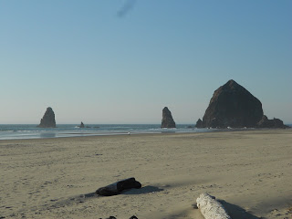
Haystack Rock on the north Oregon Coast
Scenic Haystack Rock

Haystack Rock , just north of Cannon Beach Oregon, is the third largest seastack in the world. At a height of 235 feet rising out of the Pacific Ocean just off the coast, Haystack Rock is quite a sight and a great place for photo taking. According to the USGS seastacks are blocks of erosion resistant rock isolated from the land by sea. Sea stacks begin as part of a headland or sea cliff. Relentless pounding by waves erodes the softer, weaker parts of a rock first, leaving harder, more resistant rock behind. 


Haystack Rock's Marine Garden


Haystack Rock is part of the Oregon Islands National Wildlife Refuge and as such is off limits to climbers. Two good reasons for the restriction is that birds are nesting on the rock and climbers would only destroy the nesting. The second reason is that climbers would be stranded on the rock during high tide.


What you will find very interesting is the area within about a 300 yard radius from the rock's base. This area is termed a " marine garden" area. This specific area is open to people who wish to explore but there are rules against collecting anything from the area and/or disturbing marine organisms.
Haystack Rock is protected under the U.S. Fish and Wildlife Service as a seabird nesting colony and under the Oregon Department of Fish and Wildlife. The city of Cannon Beach asks visitors to enjoy watching the wildlife in it's natural state and leave things undisturbed for others to discover and enjoy.


cannon beach oregon
Cannon Beach Oregon
It is estimated that as many as 200,000 people visit Haystack Rock annually. The most popular times to visit is during the summer when the tide pools are filled with nesting seabirds.

Cannon Beach and Seaside


There's a story of how Cannon Beach received it's name. With a name like that you just know there has to be a story behind it. 


In 1846, the USS Shark broke apart on the Columbia River Bar, one of most treacherous areas in the world. This is in the Pacific Ocean at the mouth of the Columbia. This is just north of Cannon Beach. After the USS Shark broke apart a small section of it's deck along with a small cannon eventually drifted southward and washed onto the beach just south of present day Cannon Beach. The area is called Arch Cape. Cannon Beach adopted it's name in 1922. Today, replicas of the cannon and decking are showcased at the point. The actual decking and cannon can be viewed at the Cannon Beach Historical Society Museum. 


seaside oregon boardwalk
Seaside Oregon Boardwalk
One of the biggest summer events in Cannon Beach is the annual Sandcastle Day. Cannon Beach Sandcastle Day has been known to draw about 30,000 people into the town which normally has about 1,000 residents. Teams totaling about 1,000 competitors compete in sand sculpturing in what has become Oregon's oldest and most prestigious competition of it's kind. The event usually occurs with the lowest tide Saturday in June.

Just north of Cannon Beach is Ecola State Park. Hikers will like the fact that from the cliff are trails leading down to the beach. Here you will also get a great few of haystack Rock to the south and the peaks of the Coast Range. In Chinook jargon, the name Ecola means "whale". It was a name used by explorer William Clark referring to a creek in the area. The journals of Lewis and Clark refer to a large 105 foot long whale found beached in this area.


Cannon Beach turned into a bohemian community during the twentieth century. Just to the north of cannon Beach is a town called Seaside. While Cannon Beach remained laid back, Seaside became a big coastal tourist mecca. Seaside is Oregon's oldest family beach resort.  


cannon beach oregon galleries
Gallery in Cannon Beach Oregon
This was all started when the stagecoach and railroad brought people to the area. Eventually Seaside grew to the point where it was filled with seaside hotels and vacation homes and vacation home rentals that the overflow has now spread down to Cannon Beach. Seaside today is well known for it's paved boardwalk which is the only one on the Pacific coast north of Santa Cruz California. The two mile boardwalk was constructed in 1921 replacing an old wooden boardwalk built in 1908. On the Seaside Boardwalk is a bronze statue of Lewis and Clark looking seaward commemorating the end of the trail. The Seaside Beach is long and flat and is sheltered by a headland. 

You'll be interested in two additional Western Trips photo articles that make excellent additions to your north Oregon coast vacation or weekend trip. They are a Visit to Downtown Astoria Oregon and the world famous Columbia River Maritime Museum in Astoria and the history of navigating the Columbia Bar.


The two publications below have excellent information for planning your Oregon Coast Road Trip.


In addition to Haystack Rock, the Cannon Beach Historical Museum, Seaside's beach and  the Seaside Boardwalk and the shops and restaurants in both cities, you'll want to stop by the Butterfield Cottage in Seaside. The Butterfield Cottage is Oregon's only beach side museum and dates back to around 1912. Exhibits include artifacts dating back to 700 B.C. and history of the Seaside area over the past 2,000 years.


butterfield cottage in seaside oregon
Butterfield Cottage museum in Seaside
Location of Haystack Rock, Cannon Beach and Seaside

Cannon Beach is located about 25 miles south of Astoria Oregon off of US Hwy 101. Haystack Rock is located just about a half mile north of Cannon Beach. Seaside is located about nine miles north of Cannon Beach.
This is a great drive to take along the coast south of Astoria after visiting the sites there and at Fort Stevens State Park just west of Astoria.

A good weekend trip while in the Portland area is to head northwest on Hwy 47/26 which will take you to the coast in the Cannon Beach / Seaside. After visiting the sites in that area,including Haystack Rock, you would want to drive north on US Hwy 101 towards Astoria. This will take you to the historic sites of Fort Stevens and Fort Clatsop, downtown Astoria and the Columbia River Maritime Museum. Heading back to Portland you might opt to take Hwy 30 west which will eventually connect you with Interstate 5 via Longview Washington. Take Interstate 5 south back to Portland.  It's not the shortest distance back to Portland but Hwy 30 going west from Portland follows the south side of the Columbia River and it's quite scenic.


(Photos from author's private collection)


View Larger Map