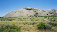
A very historically rich side trip off our nations byways is Independence Rock in Wyoming.. Independence Rock is located along the old Oregon, Morman and California emigrant trail. This trail was the main trunk line from the Missouri River to points west including the west coast. The popular story is that the emigrants wished to reach this point by July 4th thus having enough time to cross the mountains to the west before the worst of the winter weather set in. If you arrived at this point too late then the chance of being trapped in the mountains by massive snowfall was that much greater. The story of the ill fated Donner party is a prime example.
The rock, which is solid granite, measures 130 feet high and is located along Wyoming Highway 220 in southwestern Natrona County. In 1961 it was designated a National Historic Landmark. It is now a state historic park site and administered by the state of Wyoming.
 As they passed, the emigrants carved their names and dates into the rock and also left messages to those on the trail behind them. Most of these carvings can be found near the summit of the rock and they are reachable with a relatively easy climb to the top. One theory regarding the carvings is that possibly a professional etcher set up shop at the base of the rock and offered his services to passing emigrants. This however has not been conclusively proven.
 The exact location is about 50 miles southwest of Casper, WY. You can pick up State Highway 220 in Casper coming off of Interstate-25.
These sites will give you much additional information:
www.wyomingtourism.org
www.independencerock.org


