Santa Fe New Mexico is home to world famous art, art galleries, Native American culture and Spanish influences dating back to the time of it's founding in 1610. Hikers will also find plenty to do in Santa Fe.
The Dale Ball Trails
Hiking Santa Fe includes miles of interconnecting trails operated by the City of Santa Fe. In the foothills of the Sangre de Cristo Mountains among juniper and pinon, the Dale Ball Trails and the La Tierra Trails provide a network of over 50 miles of hiking and mountain biking trails.New Mexico in general offers a wide range of outdoor activities and many of them include cultural adventures.
The trails offer hikes, runs, mountain-bike rides and, as you can always count on, some great views. Because the trails are along a relatively lower elevation their use can be enjoyed year round. The Dale Ball Trail system ranges in elevation from 7000′ to 9000′ above sea level. The trails include both old trails and additional new ones.
The hiking and biking trails are located just outside the city in the foothills to the east. The Dale Ball Trails preserved more than 1,150 acres of land for local flora and fauna. With the city of Santa Fe as a backdrop, the Dale Ball Trails wind around the “foothills” of the Sangre de Cristo Mountains.
 |
| Sangre de Cristo foothill scenery |
From the city of Santa Fe you'll want to follow Alameda Street east for about one mile to where it ends in a 3-way stop.
Turn left onto Upper Canyon Road and continue east approximately one mile, until the road makes a sharp left and becomes Cerro Gordo Road. Immediately after making this left turn, you will see the parking area for the Nature Conservancy to the right. The trailhead is marked at the far end of the parking area.
Creation of the Dale Ball Trails
The Dale Ball Trails came about by the work and generosity of several people and groups. The trails were named after Dale Ball who was a longtime Santa Fe resident. Ball came up with the idea of the trail system and worked to make it a reality. The McCune Foundation along with an anonymous donor came through the the major portion of the required funding. Dale Ball secured the funds and oversaw the construction of the trails. Trails you'll choose from include switchbacks and can include steep running on both hard rock and dirt surfaces.
An important point to remember about the Dale Ball Trails is that they came about by a community wide effort. Various groups schedule working events to improve trail safety and repair erosion effects.These groups include but are not limited to the Trails Alliance of Santa Fe and Santa Fe Fat Tire Society.
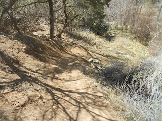
 |
| Along a Dale Ball Trail |
The La Tierra Trails are located within the city limits of Santa Fe and are on public land. All of these trails are considered easy to moderate for both hiking and biking. The plan for La Tierra Trails was put together by the city of Santa Fe in 2008. The idea was to have a multi-use trail in the northwest area of town.
La Tierra currently comprises about twenty-five miles of trails and begins only two miles from the Santa Fe plaza. The La Tierra Trails add to existing recreational trail destinations in and around Santa Fe and expands the City’s wilderness trail offerings to over 60 miles of recreational trails within a very close proximity to downtown Santa Fe. Great trails without having to make long drives to reach.
Additional Santa Fe Area Trails
Anyone wishing to hike some scenic trails around the Santa Fe area will also want to explore Hyde Memorial State Park. The park is located about eight miles north of Santa Fe in the Sangre de Cristo Mountains on the way to Ski Santa Fe.
 |
| Another Dale Ball Trail view |
Another Hyde Memorial Park Trail we enjoyed was the West Circle Trail. This 2.2 mile trail is considered difficult due mostly for the 1,000 foot elevation gain along the way. The circle loop is 3 miles long in total. You'll get some great views of the Santa Fe area through beautiful pines.
Keep in mind that the trails at Hyde Memorial State Park range in elevation form 8,400 to about 9,500 feet. This means that weather can change in a hurry and because of the dryness you'll surely need to carry along adequate water.
Links to two additional Western Trips hiking and biking articles you may enjoy include...
Hiking New Mexico
Historic Cerillos NM Hiking
(Photos from author's collection)
View Larger Map


