Western Trips

Saturday, June 30, 2012

The History of New Mexico / Galisteo Church

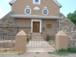
Located just a short drive south of Santa Fe New Mexico is a beautiful old mission church which traces it's roots back to the 1500's. This is the church of  Iglesia Nuestra Señora de los Remedios (The Church of Our Lady of the Remedies). The church is located in Galisteo New Mexico. The village was at one time the pueblo dwelling of the Tano Indians. This far predates the Spanish colonization of the area. Coronado's first explorations were in 1540. According to galisteoarcheology.org, the first historical record of the Galisteo pueblos was furnished by Pedro Castaneda of the Coronado expedition in 1541. The Tano Indians had a bustling multi-storied pueblo settlement. In fact, the Galisteo Basin was a thriving trade route for both the pueblo Indians and later for the Spaniards. Before the Spaniards stepped foot into Galisteo Basin, it was inhabited by about a dozen tribes and one thousand Indians. Where the village of Galisteo is located today was a 1600's Spanish land grant. The Galisteo Basin today is also one of the best known archeological sites in the United States. To the northeast lies the Sangre de Cristo Mountains and to the southwest are the Sandia Mountains which are to the immediate east of Albuquerque.

iglesia nuestra senora de los remedios
Iglesia Nuestra Senora de los remedios
The church at this site today, Iglesia Nuestra Señora de los Remedios, shown in the photos was originally constructed in 1884. It was a reconstruction of the post Spanish reconquest church built on this site. According to the New Mexico state historian, the village of Galisteo was founded about the same time as Santa Fe, perhaps just a few years later circa 1612. Another interesting historical note from the state historian is that the pueblo Indians around Galisteo actually warned the Spanish governor of Nuevo Mexico of the planned Pueblo Revolt of 1680 on the eve of the violent uprising. When Diego de Vargas explored the Galisteo Basin upon the Spaniards return in 1692, he found that virtually all of the missions in the Galisteo basin were abandoned. The church in Galisteo was in bad repair and just about ready to collapse when a rebuilding project was undertaken. In 1706 the church rebuilding was completed and about 150 families were settled in the pueblo. The new church had one nave as opposed to the three the old mission had. Something apparently affected this particular mission as opposed to the majority. By the end of the 1700's, most church missions in Nuevo Mexico were doing quite well.

galisteo new mexico
Galisteo New Mexico church
By the year 1796, the Galisteo church was virtually abandoned again. Most of this was reportedly due to the harsh drought conditions in the basin that made it almost impossible to grow crops, raise cattle and survive there. Today, the Galisteo Basin is a preserve of high desert land. Efforts have been and are made to conserve and restore the land. Visiting the historic old churches and missions in New Mexico is always interesting.

The Galisteo Basin today is one of the best known archeological sites in the United States. To the northeast lies the Sangre de Cristo Mountains and to the southwest are the Sandia Mountains which are to the immediate east of Albuquerque. The church at this site today, Iglesia Nuestra Señora de los Remedios, shown in the photos was originally constructed in 1884. It was a reconstruction of the post Spanish reconquest church built on this site. According to the New Mexico state historian, the village of Galisteo was founded about the same time as Santa Fe, perhaps just a few years later circa 1612.

The Iglesia Nuestra Señora de los Remedios Church location is also adjacent to some very fun side trips south of Santa Fe proper. The Turquoise Trail is just to the south and west of Galisteo and features several historic mining towns which are now unique art gallery and entertainment venues. These include the towns of Madrid, Golden and Cerrillos. A few miles to the north and east is Lamy New Mexico which is the scenic stop for Amtrak's Southwest Chief which serves Santa Fe.

You may also want to see the historic mission in Old Town Albuquerque.

(Photos from author's private collection)

Monday, June 25, 2012

Museums of History / Los Alamos


los alamos historical museum
Los Alamos Historical Museum
 Los Alamos New Mexico is a short and highly scenic drive northwest of Santa Fe. Many people visiting Santa Fe, Taos New Mexico or both take a side excursion up into the Jemez Mountains and visit this very historic site. Los Alamos, aside from it's thousand year pueblo history, is probably best known as being the site for the Manhatten Project during the early 1940's. It was in this town that the history of nuclear weapons began.

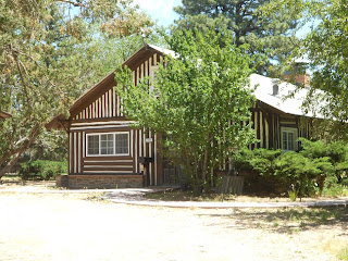
If you have the opportunity to travel to Los Alamos you'll find there's more than one good museum. One you want be certain to add to your trip planner is a very unique museum with a fun walking tour available that describes the history of Los Alamos and it's relationship to the Manhatten Project. Artifacts and actual buildings from the era are found at the Los Alamos Historical Museum which itself is housed in the guest cottage of the old Los Alamos Ranch School. The museum building is just to the north of Fuller Lodge which was constructed in 1928. Fuller Lodge was the main building for the school. Fuller Lodge itself was built of course more than a decade before the Manhatten Project. The new structure was needed in Los Alamos due to the increasing enrollment of the Los Alamos Ranch School, a private boarding school established in 1917 by a man named Ashely Pond from Detroit Michigan. The school program was fairly similar to the Boy Scouts of America curriculum.

fuller lodge in los alamos
Fuller Lodge
The Los Alamos Ranch School was purchased by the federal government in late 1942 as was most everything else in the town as part of the Manhatten Project. The school formally closed in January 1943. During the Manhatten Project, the school building was used for conferences and other adjacent buildings were used for hosuing for project personnel. During the war years Los Alamos was home to thousands of scientists. When you tour the Los Alamos Historical Museum and tour the grounds of the old Los Alamos Ranch School, you'll pass by Bathtub Row. There was a very good reason for this name.According to the Los Alamos Historical Society, the master cottages built for the Los Alamos Ranch School had cast iron bathtubs. The new housing built for the laboratory has showers but not bathtubs. Congress actually passed a measure restricting bathroom fixtures of which cast iron tubs was one. Yes, Congress' ineptitude even reared it's head in the early 1940's. The fact that these limited number of cottages from the school were already equipped with cast iron bathtubs made them both unique and desirable, thus the term Bathtub Row.

Another historic site on Bathtub Row, which has been made into a National Historic Landmark District, is the former residence of Manhatten Project Director Dr. J. Robert Oppenheimer and his family. The cottage was built as part of the Los Alamos Ranch School in the late 1920's for an artist and relative of the Ranch School director. This and the other structures at the school site reverted to federal government use with their purchase in 1942.

bathtub row in los alamos
Cottage on Bathtub Row
The city of Los Alamos today is a bit like the old Los Alamos in some respects and in others quite different. Today, Los Alamos is like any other small city with the exception that it is still home to a national laboratory. What was started as the Los Alamos Scientific Laboratory and sometimes referred to as Site Y,  focused on the building of the atomic bomb, is today the Los Alamos National Laboratory. The laboratory was managed  by the University of California since the mid 1940's. Beginning in 2006, the management operations were switched to a new concern called the Los Alamos National Security LLC which is made up of the University of California, Bechtel, Babcock and Wilcox Technical Services and URS Energy and Construction. Operating contracts usually are for seven year terms.

Today, Los Alamos National Laboratory functions as a national security research institution. It's general goal is to come up with solutions, both of a scientific and engineering nature, to help solve the nations most complex problems.

You may also want to add a side trip to Bandelier National Monument located adjacent to Los Alamos. Bandelier is a popular attraction showcasing the ancient cliff dweller inhabitants of thousands of years ago.

The Los Alamos Historical Museum is located at 1050 Bathtub Row.This is on the north side of Central Street at 20th Street. Los Alamos is about a 45 minute drive from Santa Fe. The drive itself is very scenic and you'll enjoy adding a visit to Los Alamos to your New Mexico trip planner.

(Photos are from author's private collection)


Friday, June 22, 2012

Napa Wine Tours / A California Vacation

If you're planning a California road trip in the future, a Napa Wine Tour is a good idea for your northern California vacation. Napa County is just a very short drive from the Bay Area and there is so much to see and do, many people make it a weekend or long weekend trip. The wineries in Napa County are some of the best in the world and we wanted to highlight a few on our site.

First, a few facts about Napa County California.

v sattui winery in napa county
V. Sattui Winery
Napa County was one of the original counties of California, created in 1850 when California became a state. The county's wine production goes back to the early 1800's and at the end of the century, Napa had about one hundred and forty wineries. Today, the total is over four hundred wineries. Certainly something for everyone.  The town of Napa was founded by Nathan Coombs in 1847 on Rancho Entre Napa. The city of Napa was incorporated in 1872. Like so many of the wine regions, Napa County started off as a general agricultural area. Most would say that the 1960's ushered in the era where Napa County took it's rightful place along with the famous wine regions of France, Spain and Italy.

One of the more unique wineries found in Napa County is the V. Sattui Winery. One of the things I really enjoyed visiting this winery were the magnificent grounds. There are many picnic tables on the treed grounds which just happen to be in front of the winery Marketplace. The Marketplace included an enormous selection of wines as well as a European style deli. It's a great place to order fresh sandwiches,purchase a bottle of wine and enjoy the marvelous scenery in every direction. V. Sattui Winery is located at 1111 White Lane, Saint Helena, CA on the east side of Hwy 29.

Special Annual Napa Valley Event

August 7-25 2013

Music in the Vineyards, now in its 19th season, brings together nationally recognized musicians in unique winery settings where both performers and audiences experience chamber music as it was meant to be performed. These twilight concerts with complimentary wine at intermission, witty commentary and conversation with the musicians have become a Napa Valley tradition. Detailed information at www.musicinthevineyards.org

yountville california winery
Ma(i)sonry Napa Valley
Another very unique winery we've discovered in Yountville is the Ma(i)sonry Napa Valley. The winery is located at 6711 Washington Street in Yountville and offers both an art gallery and wine tasting room. Furnishings include everything from the 16th century to contemporary styles. The artwork on display is some of the best in the San Francisco Bay area. The stone building was constructed in 1904 as a private residence and is one of three stone buildings in Yountville. Stone for it's construction came from the hills of Napa Valley.

The building is on the National Register of Historic Places. Yountville took it's name from George Calvert Yount who many contend was the very first Anglo resident in Napa Valley. Yount's history in Alta California goes all the way back to 1836 when he received a Mexican land grant and reportedly built the first log house in Alta California. The population of Napa Valley and northern California in general grew in the mid 1800's with the U.S. takeover during the Mexican American War along with the California Gold Rush which occurred within about one year of the U.S. takeover.

Visit Calistoga

calistoga california train depot
Calistoga California historic train station
Another must stop further north in Napa County is the town of Calistoga.  Calistoga is a town surrounded by vineyards and at the same time is home to the famous mud baths and hot spring spas. Calistoga also features the second oldest train depot in all of California.

Listed under the National Register of Historic Buildings, the Calistoga train depot features six restored railroad cars with historic exhibits plus retail stores. Another less publicized site near Calistoga but an excellent addition to your Napa County trip planner is Safari West. This popular tourist stop is not a zoo but instead is a 400 acre wildlife preserve.Safari West features some 400 mammals and birds. Safari West is located at 3115 Porter Creek Road  Santa Rosa, CA. This is about nine miles west of Calistoga.

Another related article we've published is about the Geyser in Calistoga, a must addition to your northern Napa County California vacation planner.

(Photos from author's private collection)
 

Tuesday, June 19, 2012

Grist Mills / Napa County California

grist mills
Bale Grist Mill, Napa County CA
Grist mills are found all over the United States. If you've taken road trips in the U.S. you have no doubt visited or at least passed by some old historic grist mills. You may ask, what is a grist mill? At one time the grist mill served as the center of town activity. The technology of the grist mill was quite simple compared to today's but the mill's beauty and simple construction draws people who want to connect with the past. In many ways the grist mill represented early technology.

The first English colonists might have starved if the Indians had not shared corn with them and taught them how to grow it. Corn was essential. The colonists dried the corn, ground it up as meal or flour and then cooked it and used it in baking. Grist mills were actually used to grind any grain. Products were cake, bread and porridge. Typically, a farmer brought his own grain to the grist mill and received back ground meal or flour and would pay the mill operator a percentage called the "miller's toll".

Today, in the United States, there are organizations devoted to the restoration of old grist mills. Truly, they are a tourist attraction as well as a glimpse back into early water power technology. Compared to today's technology, the grist mill is quite simple yet during the 1800's it provided much needed power to perform a settlements necessary chores. It should be noted that a skilled miller was a very well respected position during the golden days of the grist mill.

grist mill wheel
Close-up of large grist mill wheel
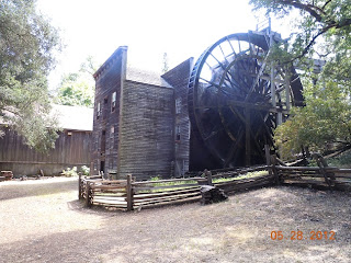
The Bale Grist Mill located in Napa County California is both an historic museum as well as a venue for special events. The Bale Grist Mill is a California Historical Park located three miles north of St. Helena on Hwy 29 in the middle of the beautiful Napa wine country.The mill and its 36 foot water wheel are protected as a state historic landmark and have been partially restored. Thousands of tourists visit the mill as part of their Napa wine country vacation or weekend road trip. The Bale Grist Mill Historical Park hosts three annual special events. These include the Old Mill Days, the Pioneer Christmas and the Harvest Dinner.

The Bale Grist Mill  is a water powered mill that was built in 1846. At one time it was the center of social activity as Napa Valley settlers gathered to have their corn and wheat ground into meal or flour. The mill was constructed by Dr. Edward Turner Bale. Bale, like many others at the time, had received a land grant from the Mexican government and resided at the site until his death in 1849. Like so many others, Dr. Bale left Napa County in 1848 to join the thousands who sought their fortune in the California Gold Rush. While in the Sierra foothills it's said that he caught a fever and died on October 9, 1849. The doctor was only 38 years old. The Bale Grist Mill lived on and remained in operation until the early 1900s. After Dr. Bale's death his widow took on managing of the property. The present 36 foot wheel you see today was installed at the mill after Dr. Bales death.

bale grist mill
36 foot Bale Grist Mill wheel
Those interested in the history and preservation of these old mills may want to learn more about the Society for the Preservation of Old Mills. This organization is international in scope.Chapters in the U.S. are spread all over the country. The Society for the Preservation of Old Mills is one of the leading groups dedicated to old mills with a large technical resource for mill restoration, machinery, techniques, and history. 

The Society, which is also referred to as SPOOM, was chartered in 1972 in Maine as a non-profit organization. Its membership includes mill owners, old mill buffs, museum curators, conservators, history writers, teachers, artists, photographers, equipment supply firms, and libraries.Membership is open to anyone who shares the purposes and interests of the Society. The organization also highlights mill events and ongoing restoration projects.

Two additional articles we've published that you'll find interesting in planning your California wine country vacation are the Geyser in Calistoga and the Buena Vista Winery, Sonoma County's very first winery. 

(Photos are from author's private collection)

View Larger Map

Monday, June 18, 2012

Jemez Springs


jemez springs new mexico
Jemez Springs NM

Jemez Springs New Mexico is a very scenic small settlement in the Jemez Mountains within the Santa Fe National Forest. Jemez Springs and the surrounding area are home to natural mineral hot springs. The hot springs are found on both public and private land. Several of those on private land are open to visitors for a fee. Bathing suits are required at all hot springs. Hot springs are found in many places in the United States. These springs arise from geothermally heated ground water coming from the earth's crust. In the Jemez Springs area the water temperature can be in the range of 140 to 180 degrees. The range of flow can be anything from a trickle to a flowing river and in some cases as geysers such as in Yellowstone National Park and in Calistoga California. 

A Scenic New Mexico Drive

The drive to Jemez Springs is as scenic as the town itself. Jemez Springs is surrounded by some of the most beautiful red rocks found anywhere in the country. When the Spaniards explored this area in 1540, the Jemez Valley had been occupied by pueblo Indians for thousands of years prior. As a result of later Spanish colonization of Nuevo Mexico, the Franciscans established a mission, San Jose de los Jemez. The mission was built in 1621 but was abandoned in the 1640's. An interesting historical note is that the massive stonewalls of the mission were constructed about the same time the Pilgrims landed at Plymouth Rock. Today, the original mission ruins which are located just on the north side of Jemez Springs are now the Jemez State Monument visited by thousands of people annually. Visitors to the ruins can take an interesting 1,400 foot walking tour with interpretive signs along the way.

jemez mountains
Jemez Mountains
The town of Jemez Springs is located in Sandoval County New Mexico and is 39 miles west of Los Alamos and a 70 mile drive northeast of Santa Fe. The two routes to reach Jemez Springs on NM Rte 4 are from either Los Alamos or from the south at Bernalillo, just north of Albuquerque. The drive from Santa Fe takes about one and one-half hours. An interesting historic side note is that Jemez Springs was one of the sites considered for the 1940's Manhatten Project which ended up being established in Los Alamos. Visitors enjoy the hot springs, the local art galleries and the restaurants. This is one of the best weekend getaways you'll find and is a perfect addition to your Santa Fe western road trip planner.

NM Rte 4 is also the Jemez Trail Scenic Byway which travels through Bandelier National Monument and the Valles Caldera crater on it's way from Los Alamos to Jemez Springs.

Special Photographic Tours Scheduled for 2013

Two three day photographic excursions of Valles Caldera crater will be offered during 2013. 
Visitors for these events will be chosen by lottery. Camping will be allowed at a designated location. Officials say the lottery closes April 24 for the first photography event, which is scheduled for May 24-26. The second events is scheduled for Sept. 20-22, and the lottery closes on Aug. 21. Anyone can apply by calling the preserve at 1-866-382-5537.

New Mexico Hikes and Scenery

jemez springs church
Jemez Springs Parish
Hikers may be interested in the trail to McCauley Warm Springs and Jemez Falls. The round trip takes about three hours and is 5.6 miles in length. It's about a one and one-half mile hike to the McCauley Hot Springs from the battleship Rock Trail head and another one and one-half mile hike to the falls. Battleship Rock is a formation that resembles a bow of a battleship. Battleship Rock is about six miles north of Jemez Springs on NM Rte 4.

The Jemez Canyon winds about 20 miles through multi-colored sandstone and volcanic layers. The canyon's 1,200 foot high walls are thick sandstone carved from wind and water action during the Permian times. Two additional articles we've written that you'll find interesting are Sanctuario de Chimayo and a Santa Fe to Taos Scenic Road Trip.


Public Hot Springs

Public hot springs in the Jemez Valley can be found at Soda Dam, McCauley Warm Springs, Spence Hot Springs and San Antonio Hot Springs. These are day use facilities and are not open for camping. All four of these public springs are located from one to nine miles north of the town. A large variety of lodging is available in and around Jemez Springs including some very good B & B's. Check road conditions for winter visits since some roads may be closed. Jemez Springs location in New Mexico is shown on the map below.

(Photos are from author's private collection)


View Larger Map

Saturday, June 16, 2012

New Mexico Tourism / Cerrillos NM

Cerrillos New Mexico is one of those intriguing old mining boom towns that today could be considered a ghost town just a short drive south of Santa Fe. Cerrillos NM at same time is a popular New Mexico tourism attraction for a variety of reasons. Located on the scenic Turquoise Trail, Cerrillos NM is both an historic and artist center which is definitely worth a visit while vacationing in northern New Mexico. Cerrillos is often referred to as Los Cerrillos which means "The Hills" in Spanish.

cerrillos
The What Not antique shop
One of the fun attractions at Cerrillos NM is the Cerrillos Hills State Park which opened to the public in 2003. The park features excellent hiking trails and interpretive signs which winds it's way past several of the abandoned mines that made Cerrillos a booming settlement. The state parks existence can be credited to the volunteer efforts of the Cerrillos Hills State Park Coalition. Cerrillos NM has also been the site for several Hollywood films including the 1988 movie Young Guns. There have been reportedly thirteen different movies that used Cerrillos as a filming set. Like many old mining towns, Cerrillos has now become a haven for artists and history buffs.

At the towns peak in the 1880's, Cerrillos NM had as many as twenty-seven saloons and four hotels. The total number of saloons has never been officially verified however as we know with the California mining camps of the early 1850's, building a saloon often required as little as a tent and a card table. Also, as in the case of many towns like it, the growth happened almost overnight. Such is the rapid growth only something like a rich mine strike will produce. Gold, silver, lead and zinc were the valuable minerals extracted from it's mines.

cerrillos new mexico mission
St. Joseph Parish, Cerrillos, NM
The area where Cerrillos is located was at one time home to pueblo Indians and the Indians were not at a loss for the minerals found there. The Indians mined turquoise in the hills long before the Spaniards arrived. The turquoise color was used extensively in Native jewelry and clothing. Today, when you visit northern New Mexico you'll find many turquoise color products sold by the local Indian population, most notably in front of the Palace of the Governors on the Santa Fe plaza. Turquoise mining there can be traced back to the Indians of about 900 A.D.

It's been estimated that most of New Mexico's turquoise production did indeed come from the Cerrillos Hills. The Spaniards themselves in the 1600's  found gold, silver and lead deposits. Much of the work was performed by pueblo Indian slave labor which was the norm at the time. It was this type of treatment of the native population which would eventually lead to the great Pueblo Revolt of 1680 that drove the Spaniards out of New Mexico for twelve years.

Cerrillos NM experienced a second boom or rediscovery in 1879 when two Colorado prospectors found rich mineral deposits in the area. There were over 1,000 mine claims filed in short order. The Santa Fe Railroad built a line down to Cerrillos in 1879. Just as with the mining towns of California, the settlement began with tents being erected and then in short order permanent structures which included saloons, hotels, churches, houses, dance halls and mercantile stores. The old Palace Hotel in Cerrillos was known to host several prominent guests during it's existence including Ulysses S. Grant and Thomas A. Edison.

hills in cerrillos NM
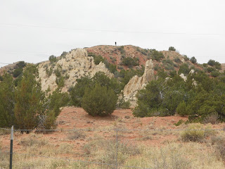
The Cerrillos Hills
The boom times lasted about twenty years. By the year 1900, the mines started shutting down and, of course with that, the population started to decline. Most people departed but some did remain. What the New Mexico tourist today will find in Cerrillos is a western looking main street witha trading post, an excellent mining museum located a few blocks west, an art gallery and the What Not Shop displaying a large selection of antiques. Cerrillos represents a significant part of New Mexico mining history and is a popular destination for New Mexico tourism.

Two additional New Mexico tourism articles we've published are Madrid New Mexico on the Turquoise Trail and the world famous Sandia Peak Tramway.

The State of New Mexico has added the Cerrillos Hills Mining District on the list of New Mexico State Register of Historic Properties. If you're looking for a perfect short day trip while visiting Santa Fe NM, Cerrollos is a perfect addition to your vacation planner. Cerrillos New Mexico is located about 25 miles south of Santa Fe on NM 14.

(Photos are from author's private collection)

View Larger Map


Thursday, June 14, 2012

The History of Fencing

So many stories about the old west, including many of those on this site, talk about the great open ranges of the early west. The history of western ranching has much to do with the availability of millions upon millions of acres of open range land. This of course came to an end when western migration reached the point where land was fenced in. The history of fencing and by default, the history of barbed wire, had about the same impact on western civilization as did the railroad. The impact on the rancher however was largely negative. There was more than one range war over fencing. As an example, the infamous Johnson County War in Wyoming had as much to do with settlers fencing in range land as it had to do with cattle rustling.

barbed
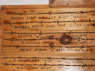
In visiting museums and studying the subject, one thing that stands out, and one that perhaps a lot of people don't realize, is that the history of fencing included many different types of barbed wire used. Although there had been experimentation with different types of fencing in the early 1860's, the story of what we know today as barbed wire had it's start in the year 1873. During that year at the county fair in DeKalb, Illinois, a man named Henry M. Rose put together an exhibit regarding a new idea in fencing. Rose's exhibit was a wooden rail with a series of sharp spikes sticking out from the sides of the rail. The fence rail which Rose patented earlier that year was designed to be attached to an existing fence to stick an animal when it came into contact with the rail. The benefit was to keep livestock from breaking through the fence.

A man named Joseph Glidden saw this exhibit and experimented with improving it. Glidden decided to design a wire that had these points sticking out from the wire itself. essentially, this is what we know today as barbed wire.The barbed wire pictures here show you all the various designs.

railroad barbed wire
Before I go any further, I want to tell you about the Kansas Barbed Wire Museum located in LaCrosse Kansas. This museum has some of the most extensive barbed wire exhibits you'll find anywhere in the world. The barbed wire museum is operated by the Kansas Barbed Wire Collectors' Association,  non-profit corporation chartered by the State of Kansas.This is definitely a venue that anyone interested in barbed wires influence on western American settlement wants to visit. The museum is located at 120 W. 1st Street, LaCrosse KS. LaCrosse is located about 10 miles south of Interstate 70 and about 160 miles northwest of Wichita Kansas.

There were a few others in addition to Joseph Glidden who developed barbed wire, filed patents and started small manufacturing companies. In the future there would be buy outs and some consolidation and a few patent fights. Glidden went through a patent battle in 1874 contesting whether he actually invented the wire in the first place. He won that court fight and went on to establish the Barb Fence Company in DeKalb. The value of this new product was recognized early on. The economics of fencing in the massive open ranges leaned toward the use of barbed wire. It was the most economical way to do it as opposed to any other way. The stone and hedge fencing used in many area of the east would be too costly and would take much too long to erect on the western plains. As a result, barbed wire came on the scene in large amount just when it was needed the most, during the large westward settlement after the Civil War.

barbed wire patents
On way to understand how the early barbed wire was manufactured is to look how Joseph Glidden produced his first barbed wire. According to information from the Kansas Barbed Wire Museum, Glidden actually used a coffee mill to make the barbs. Glidden had two pins on one side of the mill, one centered and the other just enough off center to allow a wire to fit in between. He turned the crank and the pins twisted the wire and formed loops.The wire was then clipped off about one inch on each end at an angle to form a sharp point. Barbs were placed on one of two parallel strands of wire. The two strands of wire were attached to a hook on the side of an old grinding wheel. As the barbs were positioned, the wheel was turned twisting the two strands of wire and locking the barbs in place. The end product was very usable fence wire.

Interestingly enough, a German immigrant, William Edenborn, developed a process to manufacture barbed wire that was considered more humane. He patented a process that would also make it cheaper to produce. Edenborn would later end up supplying about seventy-five percent of the barbed wire used in the U.S.

When you look at the barbed wire sample photos on this page, you will notice the large number of patents filed for a large variety of designs. This is truly barbed wire art. The manufacture of barbed wire became an art in many ways. Many different designs of the barbs themselves distinguished one from the other. In most instances, the length and design of the barbs themselves determine how much of a deterrent they are. Some can be much more harmful to cattle or anything else that comes in contact with them depending on the design.  Barbed wire fences continue to be the standard fencing method for enclosing ranch cattle in most areas of the United States.

Two articles we have published that you'll find interesting are the Johnson County War in Wyoming and the famous 3 million plus acre XIT Ranch of Texas.

For those residing in Texas, there is the Devil's Rope Museum located in McLean Texas. Here the visitor will see two large barbed wire balls weighing about 400 pounds each sitting near the museum entrance. You can tell from these pictures of barbed wire that there's a lot to see. McLean Texas is located about 75 miles east of Amarillo just off Interstate 40.

(Photos are from author's private collection)

Wednesday, June 13, 2012

Historic Towns / Las Vegas New Mexico

Historic towns are found all throughout the United States. Las Vegas New Mexico is certainly one of them. When the Atchison Topeka & Santa Fe Railroad reached Las Vegas New Mexico in 1880, everything changed. During the late 1800's, the railroads to some degree built towns. What was a small settlement would become a booming town almost overnight. In some respect, the railroad laying it's tracks through a town had the same effect as a gold rush. The railroad in many ways was the catalyst for historic towns. Most of the old buildings you see today in Las Vegas went up shortly after the railroad arrived. Today, Las Vegas New Mexico is a treasure trove of nineteenth century structures, the town now has more than nine hundred buildings on the National Register of Historic Places. Las Vegas also found it's place in early Hollywood film making. The legendary Hollywood cowboy Tom Mix shot some of his movies in Las Vegas New Mexico.

Historic Plaza Hotel, Las Vegas, NM
Even prior to the arrival of the railroad, Las Vegas New Mexico was a significant settlement. It was directly on the Santa Fe Trail and was the largest town between it and Dodge City Kansas. Quite a lot of trading went on there during the Santa Fe Trail days. The railroad of course was the start of and reason for the trail's decline but not for the decline of Las Vegas. In fact, the railroad had the opposite effect.In addition to the building construction, the railroad helped make Las Vegas a cattle rail head. Between the railroad cattle trade, the geographic location on the Santa Fe Trail and the colorful characters attracted to this new booming town, it's probably an understatement to say that Las Vegas New Mexico was one of the New Mexico towns that changed dramatically during the 1880's.
 
Many historians contend that Las Vegas New Mexico was one of the wilder of the historic towns of the west. This was quite true when it came to outlaws. Quite a lot actually happened there. More than many people might realize. One such incident was when sheriff Pat Garrett was transporting the arrested  Billy the Kid to the Santa Fe jail from the Fort Sumner area. Supposedly one of the prisoners Garret was transporting along with the Kid had a lot of enemies in Las Vegas. Garrett, his deputies and the prisoners boarded the train in Las Vegas for the 55 mile trip to Santa Fe. To get out of the Las Vegas train station in one piece, the party had to hole up in one of the train cars with shotguns at the ready. The Las Vegas mob intent in not letting the train depart. There were plenty of threats and violence looked imminent but the train car wasn't rushed. Eventually Garrett made his way to Santa Fe where Billy the Kid and the others were jailed.

View of old town Las Vegas, NM
There's another tale in this historical town about the well known Doc Holliday and Las Vegas New Mexico. It seems that Doc Holliday relocated to Las Vegas in 1879 and opened up a saloon in the middle of town with a partner. He wasn't there but a few months when an argument erupted between Holliday and a well know and locally liked gunman. Holliday apparently invited the gunman to begin shooting whenever he was ready. The gunman did and so did Holliday and the gunman was killed. needless to say, Doc Holliday left Las Vegas shortly thereafter.

Another noted outlaw from Las Vegas was Vicente Silva. In this case, Silva was a local saloon owner who gathered together a group of Hispanics into what was referred to as the Silva Gang. The gang also had other names such as Society of Bandits, Forty Bandits and Silva's White Caps. Their dubious credits included rustling, murder and theft in general. The distinction of the Silva gang was that it's leader ran a prosperous business in Las Vegas during the day and then at night turned into one of the most feared outlaws in the area. The saloon obviously served as a good front. It also came to be known that Silva had connections with a few local lawmen that aided the gang's survival. Vicente Silva died in 1893 and that pretty much spelled the end of his gang.

Amtrak's Southwest Chief at Las Vegas, NM
When you have a chance to visit this historic New Mexico town, you'll notice that the railroad built its infrastructure a short distance away from the plaza area. The Plaza Hotel shown at the top of this article was built directly on the Las Vagas plaza. The plaza represents the historic old town.The train station and the old Harvey House Hotel, La Castenada, was located one mile west. What this did was create two busy hubs in one town. The tourist visiting Las Vegas New Mexico today should make certain to tour both of these areas. The La Castenada Harvey House still stands but is vacant and the property is privately owned. Adjacent to it is the Las Vegas train station which is now served by Amtraks' Southwest Chief which runs between Chicago and Los Angeles. There's one train per day from each direction. Some travelers today get off in Las Vegas for a day or two and after touring the town get back on the train to continue their journey. There is convenient van transportation from the train station to the plaza making this an easy side trip.When you set out to tour old historic towns, if possible, give Las Vegas New Mexico a place on your trip planner. It's one of the most interesting historical towns of the southwest.

You will also want to read two related short articles, the La Castenada Harvey House and a visit to the Santa Fe Trail wagon ruts at Fort Union New Mexico. Three excellent books regarding Las Vegas New Mexico are Outlaw Tales of New Mexico: True Stories of New Mexico's Most Famous Robbers, Rustlers and Bandits by author Barbara Marriott. Also the Google eBook, Outlaws and Desperados by authors Ann Lacy and Anne Valley-Fox and the book Fred Harvey Houses of the Southwest by author Richard Melzer.

(Photos from author's private collection)


View Larger Map

Sunday, June 10, 2012

Victory Ship

When it comes to historic ships, one of the best is open to the public at the new Rosie the Riveter National Park in Richmond California. The USS Red Oak is the last of the famous Victory Ships produced during World War Two. If you live in the San Francisco Bay area or are planning a San Francisco vacation, this is one stop you want to add to your trip planner.

red oak victory ship
USS Red Oak Victory
The Victory Ship class of military vessels was derived from the Liberty Ship design. The major differences were that the Victory Ships were a bit larger and the hulls were a bit thicker than those of Liberty Ships. The new hull thickness was a result of what was learned from some Liberty Ship losses.

These Victory Ship vessels as well as the Liberty Ships before them were turned out in record time due to their being built by sections. The sections were prefabricated and hoisted into place at the Kaiser Shipyards. This allowed for rapid construction. By the end of World War Two, 531 had been built. This large number were produced from six separate shipyards in a very short length of time, from February 1944 through November 1945. Ninety-seven Victory Ships were employed as troop carriers and the others carried food, fuel, material, ammunition and general supplies.

The Victory Ships were 455 feet long and 62 feet wide and had a faster speed than the Liberty Ships. The Victory Ships averaged between 15 and 17 knots. The engines produced between 5,500 to 8,500 horsepower. Each ship had five cargo holds. Each Victory Ship usually carried a crew of 62 civilian merchant sailors and 28 naval personnel. The naval personnel were required to operate the guns and communications equipment.

victory ship gun
Stern gun showing padded gunner harness
The USS Red Oak was constructed at the Kaiser Shipyard in Richmond California and was launched on November 9, 1944. The USS Red Oak was assigned to be an ammunition carrier during the war.

The USS Red Oak saw service after the World War Two years. The ship was used as a cargo carrier during both the Korean and Vietnam Wars. When World War Two ended, there was an obvious oversupply of these vessels and many were offered for sale to commercial concerns. It's estimated that 170 of the Victory Ships were sold. Some others were loaned to the U.S. Army and the remainder were put into the reserve fleet. The USS Red Oak Victory ended up in the "moth ball fleet" moored in Suisun Bay near Martinez California in the Sacramento River. In 1968, the USS Red Oak Victory was towed from Suisun Bay to Richmond. Currently, the ship is berthed at Yard #3 at Richmond Point on San Francisco Bay.

victory ship bow
Bow view of Red Oak Victory Ship
Interestingly enough, out of the 747 ships built at the Kaiser Shipyard, the USS Red Oak Victory is the only surviving vessel which makes her even more of an historical treasure. Her name is significant as well. The vessel was named after the town, Red Oak Iowa which suffered the most per capita loss of it's citizens during World War Two. Historical statistics show that at the Battle of Kasserine Pass in February 1943, forty-five U.S. soldiers killed there were from Red Oak Iowa.

The USS Red Oak Victory is now a floating museum. This is one of the best historic ship tours you can make. The tour leads you throughout the vessel from the crew quarters to the kitchen and eating areas to the communication rooms, the captains quarters, engine room and massive cargo holds. The tour of the ships bridge is another very interesting part of the Red Oak Victory Ship tour. The bridge and the navigation room directly behind it is filled with navigation equipment of the era including a MacKay Radio direction finder. MacKay Radio was involved in the telegraphic traffic business across the Pacific at the outbreak of the war and had established radio stations on islands thus providing a signal for ship navigation.

We have three additional articles which highlight nearby San Francisco Bay maritime exhibits. They are Mare Island, the first naval installation on the Pacific coast and the SS Jeremiah O'Brien, a floating Liberty Ship museum at San Francisco's Fishermans Wharf and the Last Salt Water Steam Tugboat

It's really a terrific tour. If you have the opportunity of vacationing or visiting the San Francisco Bay area, adding a tour of the USS Red Oak Victory to your trip planner is a good idea. Also a fun and educational stop for the entire family. The SS Red oak Victory is open for visitors Tuesdays, Thursdays, Saturdays and Sundays. Hours are 10A-3P. The ship is berthed at 1337 Canal Blvd., Richmond, CA.

(Photos are from author's private collection)


View Larger Map

Friday, June 8, 2012

Electric Railroads / Pacific Railroad History


Electric railroads grew tremendously during the first part of the 1900's as did rail transportation in general. Many of us are familiar with the electrified rail cars that plied the streets of many if not most American cities during the first thirty years of the 20th century. The dc rail system proved to be an efficient and reliable mode of transportation.  In addition to these urban transports, there were many electric interurban railroad lines that sprang up in many regions. Some were not necessarily connecting large cities. When electric trains started to connect smaller towns to one another this in effect presented competition to the steam locomotive railways and, as you can imagine, there were more than one showdown between the two.

A Railway From Petaluma to Santa Rosa California

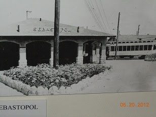
The building out of the Petaluma and Santa Rosa Electric Railroad that connected several towns in Sonoma County California is one case in point and an interesting one. Sonoma County played a big role in Pacific railroad history. The Petaluma and Santa Rosa electric railroad connected both of those Sonoma County towns as well as Sebastopol, about 10 miles west of Santa Rosa. Petaluma passengers could be transported to San Francisco via the railroad's ferry. This was important since the railroad through it's ferry could bring Sonoma residents directly to the city on the bay. The electric railroad line ran as far north as Forestville.

Competition and the Frog Wars

north california electric railroads
There was big competitive friction between the new electric railroad and the steam railroad which had been operating between Santa Rosa and Sebastopol since 1890. In other words, there were parallel rail tracks. The electric railroad however had to cross the steam railroad's tracks to reach downtown Santa Rosa.

The conflict involved work crews from each railroad. One representing steam railroads and one from the electric railroads. Interestingly enough, this same type of conflict occurred in southern California in 1882 between the Southern Pacific Railroad and the California Southern, a subsidiary of the AT & SF Railroad. These conflicts were referred to as "frog wars", named after the devices built to intersect two perpendicular rail tracks. The "frog" in effect was a crossing. This particular conflict involved a crossing at Colton California. In both cases, the one in southern California and the one in Santa Rosa California, there were court injunctions, stand offs, miscommunications and eventually the crossings were made.

sebastopol railroad museumIf you have the opportunity to visit Sonoma County and Sebastopol in particular, there is an excellent railway museum that was built inside the old electric railway depot.

The West County Museum explains the railroad history in both Sebastopol and in Sonoma County in great detail. Plenty of unique old photographs and authentic artifacts of the era. These electric railroads had there heyday during the first part of the 1900's. Much of the electric railroads tracks were torn up after service ceased. Some of these right of ways have been converted to hiking and bike trails. Ironically today, the need for mass transportation is front and center and the clean energy that electric railroads rely on is the preferred power. There currently are plans in Sonoma County to resurrect electric mass transportation with the SMART system that will connect Sonoma to Marin County to the south. It will be interesting to see how the SMART system unfolds. Just like the early electric trains such as the Petaluma and Santa Rosa Railroad. the goal will be to connect the north counties to San Francisco.

west county railroad museum
Again, if you have the opportunity to enjoy a trip to the beautiful Sonoma wine country, adding a trip stop to the West County Museum in Sebastolpol will be rewarding.You might also make note that Sebastolpol is a relatively short drive to the Pacific coast at Bodega Bay.

If you visit Bodega Bay, in addition to the great seafood available there, I would take a short ten minute drive out to Bodega Head. Here you will find some of the best views on the Pacific coast along with some scenic hiking trails. Bodega Head is also a popular whale watching site. Have a great trip.

Another article you'll enjoy is a self guided tour of the old Central Pacific Railroad tracks from Auburn California to Donner Pass. See our article, Rails, Tales and Trails.

(Article is copyright 2013 Western Trips. Photos are from authors private collection. Old electric railroad station photos courtesy of West County Museum)

Sebastopol California is shown on  map
View Larger Map

Tuesday, June 5, 2012

Best Mountain Bike Trails / The Great Divide Mountain Bike Route

If you're searching for a high adventure western trip and you have the physical ability and the time to prepare and partake in it, an absolutely spectacular mountain bike route in the western U.S. is available to serious cycle enthusiasts and is among the best mountain biking trails.


boreas pass
Boreas Pass, Central Colorado
The Great Divide Mountain Bike Route also referred to as the Great Divide Route or by some, the Continental Divide Trail is one of a kind. Whatever name you prefer to call it, it's one very unique mountain bike route and the longest off-pavement route in the world.

One big reason this is a popular route for adventurous road bikers is that you can literally ride the trail from Canada to Mexico and the scenery along the way is obviously both diverse and spectacular.

The bike route geography varies from scrub desert to alpine mountain. Elevations also vary to a large degree. Over the vast majority of this bike route, the cyclist will either be ascending or descending. The cycle tail literally offers something different each day and I think this is one of attributes that make this route one of the best mountain biking routes you'll discover.

Being about 2,500 miles in length, the Great Divide Mountain Bike Route is the world's longest. I should point out that there's an excellent book published about the trail. Cycling the Great Divide, by author Michael McCoy, gives an excellent description of the trail and is a good read if you plan on either taking on the entire trail or just a portion of it.

About 80% of the bike route is made up of county, Forest Service, and Bureau of Land Management dirt and gravel roads. The remainder is a combination of paved roads, four wheel drive tracks and single track trails.

A north to south route along the Great Divide goes through a variety of climates. For those starting out in the northern section, the window of cycling this portion runs from about mid June to the end of September. The best authority on learning about and enjoying riding the Great Divide Bike Route is the Adventure Cycling Association. The Adventure Cycling Association is credited with establishing the bike route. The association offers maps, information about services available along the way and invaluable tips that will help make your journey both safe and as comfortable as possible.The association also suggests that would be trail cyclists also consult U.S. Forest Service maps as well.

new mexico mountains
Northern New Mexico scenery
The Great Divide bike route is known to be divided into five sections. The Canadian section that goes to Banff Alberta runs through several beautiful Canadian national parks. With the addition of the Canadian bike route, the entire bike route now is over 2,700 miles in length. The bike route in Canada also offers 114 miles of virgin riding through British Columbia's Flathead and Wigwam River valleys.

On the other end of the Great Divide Mountain Bike Route, the trail enters New Mexico in the San Juan Mountains and travels through the Carson National Forest. This is a very spectacular part of the bike route in as much as the rock colors are very beautiful. The mountain route then passes the small village of Abiquiu. This was at one time the home of the famous 20th century artist, Georgia O'Keeffe.

Further south you'll pass over the Jemez Mountains, east of Santa Fe, and through the town of Cuba New Mexico. After this segment, the bike route passes Chaco Mesa and the Cibolo National Forest. The landscape is of pinon studded plateaus,  arroyos, tall volcanic plugs, and abandoned ranches.


gila national forest map
Map of Gila National Forest, New Mexico
The last town on the southern section is Silver City New Mexico and beyond that lies essentially about 100 miles of desert before reaching the Mexican border.

The southern end of the route is Antelope Wells NM, right on the U.S. border with Mexico. NM Hwy 81 links it with Interstate 10 to the north.

As mentioned above, the Adventure Cycling Association is the authority about anything you wish to know about the Great Divide Mountain Bike Route.

The association's stated goal is to inspire people of all ages to travel by bicycle. They can help you explore this great country and the fascinating Great Divide route for fitness, fun, and self-discovery.

You may also enjoy our Western Trips article on the White Pass Scenic Byway in Central Washington state.


(Boreas Pass and Gila National. Forest map are from the public domain. New Mexico mountain photo is from author's private collection. Article copyright Western Trips)

Sunday, June 3, 2012

World War Two Memorial / Rosie the Riveter

rosie the riveter poster
We Can Do It poster
The National Park Service project of the Rosie the Riveter World War Two Memorial is alive and well in Richmond California. On a recent visit to the new Visitor Center I was very impressed with the exhibits on display. You'll find a trip there very interesting with a lot of information you may not have been aware of.


The We Can Do It poster at left has been popular for decades. It stands as a symbol of Rosie the Riveter. This particular poster was created by J. Howard Miller who was employed by Westinghouse's War Production Coordinating Committee to create several posters for the war effort.

Rosie the Riveters of World War Two

Because of Rosie the Riveter, the United States was able to produce the materials of war needed to win World War Two. Who was Rosie the Riveter? In actuality, there were thousands and thousands of Rosie the Riveters working in factories all across the U.S. With the available male workforce reduced, Rosie the Riveters filled this void. The statistics are quite revealing. During the peak war years, it was estimated that women made up 27 percent of the Kaiser Shipyard workforce. Women made up some 80 percent of the workforce in other industries. Rosie the Riveters were crucial to this country's war effort during the early 40's.

As part of honoring the work done so many decades ago by this essential female workforce, the National Park Service is introducing the Rosie the Riveter World War II Home Front National Historical Park. This World War Two Memorial park is located on the waterfront in Richmond California, just across the bay from San Francisco. The park is an ongoing project for the NPS. This unique park serves, among other things, as a World War 2 memorial. The park is located at the site of the old Kaiser Shipyards. I had the opportunity of attending the grand opening of the Rosie the Riveter Visitor Center and it's a great place to visit. If you're visiting the San Francisco Bay area, you will want to add this to your trip planner. There is just an incredible amount of history being displayed at this new NPS venue. The World War 2 vintage artifacts are many.

Rosie the Riveter Museum...A Must Stop

ford plant in richmond california
Richmond,CA Ford Motor assembly plant
The exhibits in this well laid out Visitor Center, which is in essence a World War Two museum, are really one of a kind. The vintage posters and photos of the era are displayed all along the walls with authentic artifacts displayed in glass cases. Just to mention a few of the many exhibits are authentic welding masks, gloves, hard hats, riveting tools, a very informative video explaining what it was like for war production workers in Richmond California during the early 1940's. All exhibits are the real thing.

Everything about this well planned World War Two Memorial park is centered on the home front during World War Two in general and the San Francisco Bay area and the Richmond war production facilities in particular.

Adjacent to the Rosie the Riveter Visitor Center is the old 50,000 square foot Ford Motor Company assembly plant which during the war was turned into a tank and military vehicle production facility. The official figures released were that some 49,000 jeeps were built there as well as 91,000 other military related vehicles including 60,000 tanks. The old Ford plant is also on the Richmond waterfront. It was closed in 1956. Today, when you visit this old factory you'll enter a very large area on the water side which can accommodate large functions and displays related World War Two exhibits. The old Ford assembly plant is listed on the National Register of Historic Places.

The Red Oak Victory Ship

rosie the riveter visitor center
Rosie the Riveter Nat'l Park Visitor Center
In addition to the World War Two museum at the Visitor's Center is the Red Oak Victory Ship docked at Point Richmond, just a few minutes from the Visitor Center itself. 

You really want to take a guided tour of this legendary ship to appreciate it's full history. Your Red Oak Victory Ship tour will essentially take you through the entire ship, including the bridge, with very good interpretive talks along the way.Within the lower large cargo hold area are a large amount of fascinating exhibits and an interesting gift shop.

The Victory Ships were along the same lines as the famous Liberty Ships however the major differences were that the Victory Ships were a bit larger and the hulls were more strengthened and more were produced. The Liberty Ship basic design was used to build the Victory Ships. In essence, the Victory Ships enhanced the Liberty Ship attributes.

red oak victory ship
Red Oak Victory Ship
The Rosie the Riveter World War Two Memorial is one of the very best I've seen. It's purpose is honoring American Women's labor during the Second World War.

Many historians and others have pointed out how World War II so dramatically changed the San Francisco Bay area and northern California. The economic impact on the region has been compared to the Gold Rush days of the 1850's. Richmond California itself went from a small town to a booming war production venue almost overnight. In some ways quite similar to how gold mining camps exploded into full fledged towns overnight.

Following are links to two short articles regarding the home front during World War Two. San Francisco WW II Defenses and Galveston's World War Two Action.

The link for Rosie the Riveter Home Front National Park.

I hope you have a chance to visit this very unique new National Park.

(Photos are from author's private collection)

Directions from the Oakland/San Francisco area:
Interstate 80 East.
Exit to I-580 West towards Richmond/San Rafael.
Exit Marina Bay/South 23rd Street.
Turn left (over the freeway overpass), drive approx. 1/2 mile.
Turn right onto Regatta.
Turn first left at Melville into the parking lot of Marina Bay Park.

If you're driving from Sacramento:
Interstate 80 West.
Exit on Cutting Blvd., drive approx. 1 1/3 miles.
Turn left on 23rd Street.
Turn right onto Regatta.
Turn first left at Melville into the parking lot of Marina Bay Park.


View Larger Map